Fall 2005
Fall 2005 |
|||||||
|
|
|||||||
American Red Cross Uses GIS for Hurricane Katrina and Rita Efforts |
|||||||
The American Red Cross is in the business of helping people, providing relief in response to natural disasters for nearly 150 years. Its mission as a humanitarian organization led by volunteers, guided by its Congressional Charter and the Fundamental Principles of the International Red Cross Movement, is to provide relief to victims of disasters and help people prevent, prepare for, and respond to emergencies. The American Red Cross responded to Hurricane Katrina with tens of thousands of new volunteers bringing aid to hurricane survivors. More than 177,000 American Red Cross workers from all 50 states were deployed on the scene to provide more than 19 million hot meals and 2.6 million overnight stays in 902 shelters across 25 states. The American Red Cross estimates Hurricane Katrina relief will exceed $2 billion, with assistance including food and shelter, emergency financial assistance, physical and mental health services, and more. As part of its hurricane emergency management strategy, the American Red Cross used GIS for its many different hurricanes Katrina and Rita relief efforts. Computer mapping, spatial analysis, and GIS Web services assisted the agency in providing communities and displaced people with food, clothing, shelter, and other essential services. Whether setting up shelters, hotel housing, or emotional support programs or providing meals, GIS technology helped support senior-level staff at its headquarters in Washington, D.C., as well as staff operating at local forward command centers. "We use GIS at the American Red Cross to provide information to senior executives who use maps to make better, more informed decisions," says Greg Tune, lead program manager for disaster assessment and GIS, American Red Cross. "The types of work we do using GIS would have been very slow moving without the technology. What would have involved foldout paper maps and 'sticky' notes now is a fully automated, constantly updated process. Perhaps most important, the kinds of mapping and analysis we can do can be targeted based on need or request. We are more responsive and effective because of the technology." The American Red Cross and GISEsri provided on-site staff and resources from its Washington, D.C., office to quickly expand and extend the existing American Red Cross GIS platform. In addition, Esri specialists at the Redlands, California, headquarters worked closely with American Red Cross personnel to develop a Shelter Locator ArcWeb Services Web site (arcweb.esri.com/redcross) that provided information, such as address, capacity, population, and other descriptors available to both internal American Red Cross staff and the public.
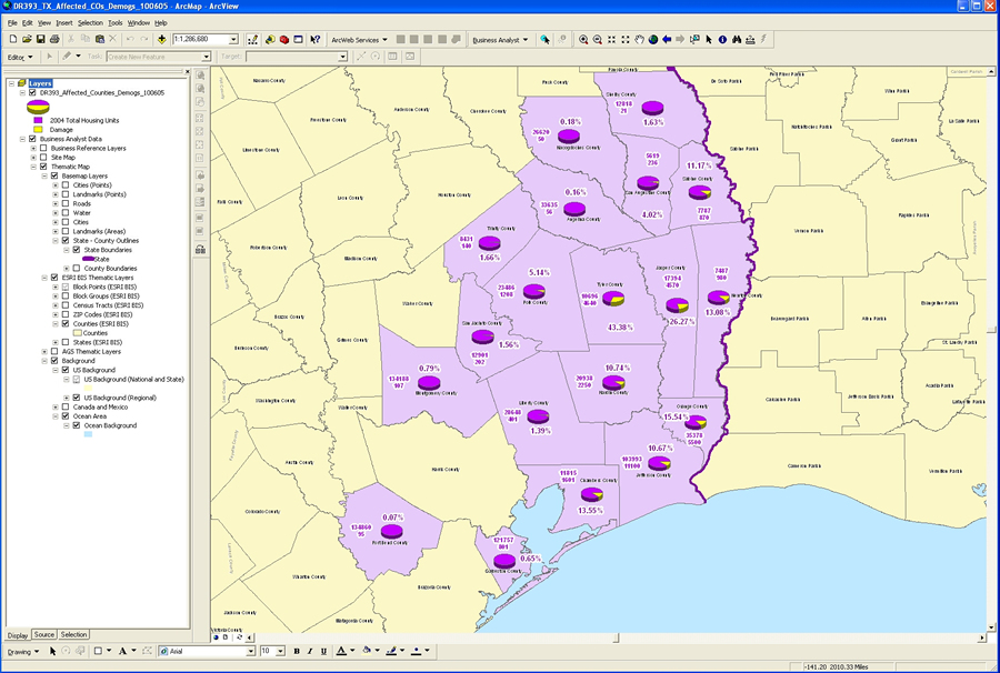
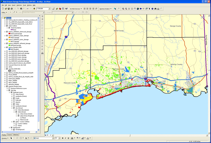
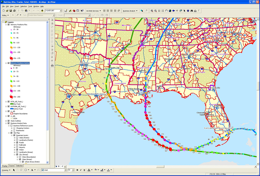
General mapping and GIS support included maps used for preplanning and response. Personnel, equipment, supplies, and other resources were strategically placed and planned for using GIS-generated maps prior to hurricanes Katrina and Rita making landfall. This included identifying counties at risk and counties that would serve as host sites for shelters, supply centers, and other forward operating facilities. As the hurricane barreled over land, work was done on the fly using ArcView software's ArcMap application to calculate exactly what was happening at various locations. Postevent response included damage assessments; hurricane wind field GIS-generated maps; and maps, charts, and reports depicting the number of people impacted by the hurricane, including displaced people. The high volume and demand for maps and GIS analysis resulted in thousands of maps generated and used throughout the American Red Cross. "We typically start with county-level maps, which is how the American Red Cross tends to start analysis, with larger city layers, including streets, highways, chapter jurisdictions, and other infrastructure, and we add to it," says Tune. "This includes wind fields, damage polygons digitized from remote-sensing imagery, and extracted demographics. This helps us better understand the population and affected households and other factors involved in shelter, feeding, medical assistance, and other American Red Cross services." GIS had been deployed by the American Red Cross prior to the impact of hurricanes Katrina and Rita, aiding in its ongoing planning sessions and thousands of relief operations the organization responds to every year. GIS helped the American Red Cross map potential shelters and American Red Cross jurisdictions and identify potential hurricane "risk" and "host" counties among its network of more than 800 chapters. Once identified, the American Red Cross could then better work with local governments and local emergency management in planning sessions that ultimately helped in its Katrina response and will help in future events.
The American Red Cross also uses ArcView with ArcGIS Business Analyst, ArcGIS Tracking Analyst, ArcGIS Spatial Analyst, and ArcSDE. "We're the information provider," says Tune. "We take raw data and help turn it into something people can read and understand. Maps with demographics, tables, and other information are what we provide for prestaging and postevent assessments and response. When the storm hits and makes landfall, we're much better prepared and closer to the action to get our resources in to help the people who have been affected." In addition, a separate hurricanes Katrina and Rita internal Web mapping application utilizing ArcIMS was implemented for use by the American Red Cross chapters and staff in the field to view all types of information in customized digital map form. American Red Cross users could log on to the site and select map layers for shelters, kitchens, damaged and flooded areas, affected ZIP Codes, and evacuee hotels. Data was provided for various dates, so users could access information within a temporal context and view the hurricane impact over time. Viewers could pan, zoom, identify items, and select specific information they would like to map. "Emergency response depends on accurate data that can be integrated from a number of sources and translated into actionable, useful information," says Tune. "That's the power of GIS. It helps in all phases of an emergency, including planning, mitigation, preparedness, response, and recovery. It played a vital role in our hurricane response, and it will play a vital role in the future." "Using GIS technology," says Eric Maier, Esri commercial account manager, "the American Red Cross was able to better plan prior to hurricanes Katrina and Rita, as well as respond with greater flexibility and precision after the events occurred." For more information, contact Greg Tune, lead program manager, Disaster Assessment/GIS, American Red Cross Preparedness and Response Operations (tel.: 202-303-8659, e-mail: tuneg@usa.redcross.org). |