Store
|
Contact Us
|
Careers
Home
Industries
Products
Training
Support
Services
Events
News
About
About Esri
Careers
Esri Video
Partners
ArcNews Online
FALL 2005
COVER STORIES
T-SHIRTS WORLDWIDE
ArcNews Online
shares
selected
articles from the print edition.
Now with exclusive online-only articles.
Previous Issues
Summer 2005
Spring 2005
Winter 2004/2005
Fall 2004
GIS Helping Manage Our World
by Jack Dangermond
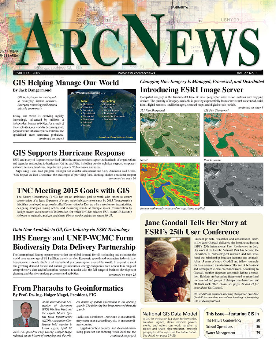
Introducing Esri Image Server
: Changing How Imagery Is Managed, Processed, and Distributed
GIS Supports Hurricane Response
-
|Online Only Article|
American Red Cross Uses GIS for Hurricanes Katrina and Rita Efforts
-
|Online Only Article|
Missouri Department of Economic Development Maps Business Impacts of Hurricane Katrina and More
-
|Online Only Article|
GIS Volunteers Help in Mississippi's Hurricane Katrina and Rita Response
Jane Goodall Tells Her Story at Esri's 25th User Conference
-
GIS in Chimpanzee Research and Conservation at JGI
Esri's 25th User Conference Continues Tradition of Innovation
IHS Energy and UNEP-WCMC Form Biodiversity Data Delivery Partnership
From Pharaohs to Geoinformatics
GIS for the Nation: the National GIS Data Model
Mexico, China, and Utah—Esri T-Shirts Get Around!
T-shirt Photos from Previous Issues
GIS PRODUCT NEWS
GIS IN ACTION (cont'd)
FOCUS ON WATER
MANAGEMENT GIS (cont'd)
Community Vision Projects Can Help "Visualize" Customers
-
What Is Community Tapestry?
ArcPad 7 and ArcPad Application Builder 7
What's Happening on the Esri Developer Network
ArcGIS 9.1 Business Analyst Now Shipping
: New Release Includes ArcGIS Network Analyst and ModelBuilder
GIS IN ACTION
The City of Chesapeake, Virginia, Uses GIS in Its 2026 Comprehensive Plan
Wales Meets European Union Agricultural Land Regulations Using GIS
Exclusive
ArcNews Online
Articles
Bridging the African Divide with GIS
Esri Business Partners Respond to Users' Needs
: A Variety of Data, Software, and Services Solutions
Bringing Foster Care Management into the 21st Century with GIS
: Groundbreaking Approach in Washington State
U.S. Military Uses GIS for Transportation Logistics and Real-Time Tracking
Natural Resources, Conservation, Planning Highlighted in ArcIMS Sites
GIS AND THE
NATURE CONSERVANCY
Overview: The Nature Conservancy
The Nature Conservancy Uses Mobile GIS Technology in Fight Against Invasive Species
Caribbean Basin Ecological Assessment Uses GIS to Model Connectivity
: The Nature Conservancy's Work Eclipses International Borders
International Efforts Support Equatorial Pacific Ecoregional Biodiversity Assessment with GIS
HIGHLIGHTING GIS
IN SCHOOL OPERATIONS
Earning All A's in Facility Management at Detroit Public Schools
In Hawaii, Land Managers, School Administration, and Students Now Have Efficient Access to a Variety of Land Data
: Kamehameha Schools webGIS System
FOCUS ON WATER
MANAGEMENT GIS
The City of Ballerup, Denmark, Integrates Urban Water Modeling and GIS
|Online Only Article|
Witte Museum Uses GIS to Make a Splash in Its New "World of Water" Exhibit
The State of Louisiana Develops Watershed Implementation Plans with GIS
: Helping Comply with the EPA's Clean Water Act
South Dakota Rural Water System Improves Operations Using GIS
GIS COMMUNITY NEWS
Regional Growth Around Washington, D.C., Envisioned with GIS
: Reality Check—A One-Day Visioning Exercise
Crossing Borders
GIS and Drug Addiction
: A column by Doug Richardson, Executive Director, AAG
GIS Reveals the Ups and Downs of the Boston Marathon
Idaho State University Creates Innovative Program in History and GIS
Esri China (Hong Kong) to Host First Asia-Pacific Conference for Esri Users
2005 Middle East and Africa Conference for Esri Users
: December 6–8, 2005
Ingenuity Fuels ArcWeb Services Challenge Winners
Free Esri Publications Offer Valuable Information
ArcGIS Enterprise Security Controls White Paper Available