Fall 2005
Fall 2005 |
|||||||
|
|
|||||||
Earning All A's in Facility Management at Detroit Public Schools |
|||||
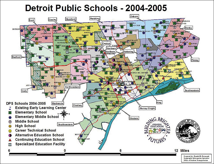
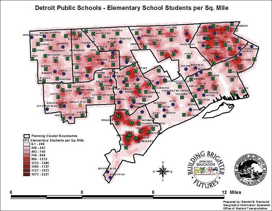
Automotive factories were once scattered throughout Detroit, Michigan. The industry drew workers from all over the world, helping the population soar. Today, Detroit still ranks as Michigan's largest city with an estimated population of 911,000, yet the city has seen a significant decrease in population since 2000. Much of the cause is the reoccurring closure of automotive factories, forcing citizens to leave the area in search of work opportunities. As workers leave, they take their families with them, including children attending schools in Detroit Public Schools (DPS). The result is a domino effect that strains the district as the population of students declines. Since 1999, DPS has lost almost 40,000 students from various schools, leading to an approximate $213 million deficit. "This year we closed 30 schools," says Randy Raymond, DPS GIS specialist. "One of the difficulties we've had in closing so many schools is trying to understand all the elements that have to be considered when you're having to close that many facilities." In the past, DPS administration picked schools for closure based on assumptions. "In order to determine which schools to close," says Raymond, "the CEO of DPS and his staff reviewed a list of 140 buildings, then offered their opinions. They didn't have any kind of data matrix that presented critical information and showed the impact of closing each school." Raymond recognized the need for a better decision-making process and created a GIS application with ArcInfo that enables the staff to conduct spatial analysis on their possible decisions. As the district's GIS specialist, Raymond already had information about all the school facilities as well as student enrollment information. Two years ago, the DPS Transportation Task Force incorporated all student addresses into a U.S. Postal Service Coding Accuracy Support System-compliant addressing system. Raymond also used Dynamap/Transportation street data provided by Esri Business Partner Tele Atlas/TomTom North America. "I have access to all the files of active students in the school district and we geocode those students," states Raymond. "We're geocoding 140,000 to 145,000 students a day, looking at how they're moving and other information. We're getting all but 250 students on the map. On a single batch pass we get 99.4 percent of the students on the map with no other user intervention." Once the student data is in the Microsoft SQL Server geodatabase, DPS is able to deliver the information through Active Server Page applications that can be accessed through Internet Explorer. This enables DPS to use the information outside their internal purposes, including for No Child Left Behind transportation notifications.
The final database combines all the data, which includes the physical information about facilities, such as the age of the building, the number of classrooms, and recent renovations, with the student enrollment information that identifies how many students live in a particular area versus go to school in the same area. The geodatabase is used for several purposes, all with the same goal of helping the district manage its facilities. At the same time, under the direction of Karen Ridgeway, the Office of Research, Evaluation, and Assessment uses the geodatabase with ArcInfo and the ArcGIS Spatial Analyst extension to give the district staff more thorough information with which to make their crucial educational decisions. "Using a geodatabase and ArcInfo," says Raymond, "you can not only utilize map graphic output, but you can also strategize about the impact of closing a school and plan where the kids would go, as well as forecast the impact on the surrounding buildings." As an example, DPS closed 30 schools, which touch 128 different school boundaries. Using spatial analysis, joining students to boundaries and students to schools, it is possible to run what-if scenarios and present the impact to the other schools. Closing one school could impact four or five other schools. The system also helps the district analyze the impact of special education program placement. Many students with specialized needs require transportation services to get to school. Through collaboration and cooperation between the Office of Student Transportation, Pupil Population Management—Student Information Systems, and the Office of Specialized Student Services, it has been possible to receive a "structured" dataset that contains all of the critical information about every special education student. In addition to the student's disability information, the dataset includes specific information about the student's educational program and the special education teacher(s) assigned to that student. Through simple data queries, it is possible to identify special education classrooms that have spaces available for placing students. This enables special education students to be placed in schools as close to home as possible. This translates into reduced cost for transportation and less time on the bus for the students involved. At the same time, the staff can consider the different ratio of students to teachers in special education programs. There is a ratio of 15 (or less) to 1 for the special education programs, versus a ratio of 30 to 1 in other classrooms. So, in a scenario involving a certain number of these programs, you can only put 15 students in a classroom, affecting the overall number of students in the facility. The ability to view this scenario helps decision makers see the potential of the facility, even if the student population is lower than another school without as many special education programs. The scenarios, presented in weekly closure and consolidation meetings, result in a thorough review process. Raymond is present and uses ArcInfo to make changes to scenarios as staff members have questions. "The information is constantly being reviewed," says Raymond. "We're really trying to take the model of schools to a different level in terms of the finances of the schools. When we're closing schools and trying to eliminate a deficit, we need to know which schools we should close that are costing us the most money versus just closing a school because it has a small population. Without bringing all the data elements together, you can't really make a good decision. For example, in Michigan, the basic foundation grant for each student is roughly $7,000. If you have a school with a capacity of 400 and 300 kids are going there at $7,000 apiece, does that cover the cost of all the administration, teachers, and expenses of the building? You might be able to keep the building open and put more students in it and have them be financially successful. Until you bring all the data elements together and visualize them, you really can't see this pattern." The overall result of Raymond's efforts is a decision support matrix that enables district administration to make more informed, better decisions. As an added benefit, using ArcPad, it is possible for all of the Pocket PC-equipped administrators to carry the decision support matrix around with them as they visit buildings in the district. This includes newly appointed CEO William F. Coleman III. Instantly, he knows information about a school, such as how many teachers and students are in the school, what the school budget is, what the test scores are, and other valuable information. The application is simple to use, enabling Coleman to click on a point file to bring up a table to see everything in the palm of his hand. By leveraging the district's technology investments, Coleman is prepared to answer questions at any time. Detroit Public Schools continues to move forward with GIS integration. The next step is an enterprise GIS management system that maintains the value of the district's IBM AS/400 system. "DPS upgraded its Esri software license to a university site license that allows us to use the full integrating power of ArcGIS Desktop and ArcSDE," says Raymond. For the future, Raymond sees GIS not only as an enterprise-wide system for the district, but also in the hands of the students, enabling them to learn about the potential of the technology. In a time of budget constraints and changing education standards, GIS is a powerful tool to battle the obstacles of change and welcome the potential of the future. For more information, contact Randy Raymond, GIS specialist, Detroit Public Schools (tel.: 248-910-7830, e-mail: randall.raymond@detroitk12.org). |