Fall 2005
Fall 2005 |
|||||||
|
|
|||||||
Kamehameha Schools webGIS System
In Hawaii, Land Managers, School Administration, and Students Now Have Efficient Access to a Variety of Land Data |
|||||
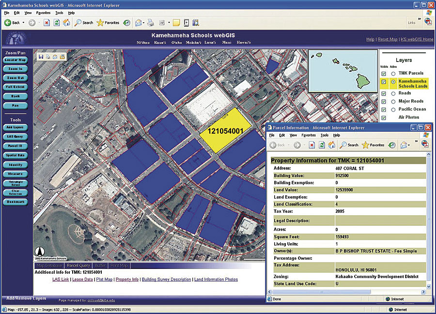
Approximately 360,000 acres of abundant tropical land in the Hawaiian islands make Kamehameha Schools (KS) one of the most beautiful locations to go to school. However, the private school system is more internally complex than first impressions would suggest. At the will of Bernice Pauahi Bishop, the great-granddaughter and last royal descendent of Kamehameha the Great, the land was set aside in trust in 1887. KS, the largest private landowner in the state, includes a K–12 campus on Oahu, K–11 campuses on Hawaii and Maui, and 31 preschool sites statewide. In addition, KS gives millions of dollars in grants to college students. The combined 6,500 preschool through grade 12 student enrollment makes Kamehameha the largest independent school system in the United States. Beyond the vast educational establishments located in KS's realm, there is an intricate business system that manages the many tenants that share the area with the schools. The endowment group combines operations in residential, commercial, agricultural, and conservation with other investments funding the schools' maintenance and educational needs. KS's unique situation produces a problem that is common among many agencies and organizations that rely on a variety of data. Given the number of organizations operating within the vast area, it was important to have accurate and current information to share with the schools, more than 20 land managers, and other KS employees. The KS Land Assets Division accumulates and maintains the different types of information that come from multiple sources. In 1998, the division hired Craig Clouet as their GIS manager and used ArcInfo on UNIX to maintain land information, such as its location, zoning regulations, who is leasing which area, and other business information. Eventually, the organization migrated to ArcView, which facilitated business functions for the KS land managers and enabled them to work with their parcel, leasing, imagery, and feature data. Since KS initially kept school operation separate from the business side of managing the land, the system worked well. However, it was inevitable that as the schools grew, they needed access to the same land information as business operations. "Lately there's been more and more 'cross-pollination' where school administration wants to know where to build new preschools," says Clouet. "To find the best location, they want to know where Hawaiians live according to census data. Once they determine the best location for a future school, they need to know other land information, such as zoning and transportation, how close it is to a flood zone, and other information that helps them serve their students more efficiently." It became apparent that as more facets of KS were depending on the same data, they needed a system that could handle the robust GIS library of data necessary for 8,000 parcels of land that would also provide a centralized way to access the information. Clouet determined the best way to do this was to use ArcIMS and ArcSDE to create an accessible Web site for the land managers, as well as the school administration and students. Clouet turned to Steve Lettau, a consultant with the Onyx Group (Honolulu, Hawaii), an Esri Business Partner, to create the KS webGIS system.
"We took the functionality and custom extension in ArcView and put it into ArcIMS," says Lettau. "That's what defined the whole process. With the custom extension built into the ArcIMS Web site, the information wasn't limited to only those with ArcView." The first step in building the ArcIMS application was data conversion. Most data was in shapefiles and native image file formats, but KS financial information was in an IBM AS/400 mainframe. The data had to be converted to DBF format so it could work with shapefiles. "Part of the whole process of what we incorporated was moving to ArcSDE and ArcIMS," says Lettau. "We put all the shapefiles in ArcSDE on SQL Server to complete the data transformation." Once the data was transferred, Lettau added more functionality to the application. Along with identify, zoom in, zoom out, pan, and other basic functionality, there were specific tools land managers needed, including links to financial and leasing information, historical maps that contain historical surveys, and other business requirements. This data, along with all-attribute data for the statewide dataset available online, was added to the system and is maintained with ArcInfo. The end result of Lettau and Clouet's work is a robust Web site that gives users a one-stop location to find the information they need. The KS webGIS contains approximately 150 layers categorized into groups, such as demographic, environmental, Hawaiian, parcel and property, political, and physical features. Users can build customized maps using these datasets to perform specific analyses. The system also links to two external databases. One is the land asset system, which contains lease information and other business data, and the other is the map imagery database, which contains historic maps of Hawaii that users can view to learn about the historical significance of the land. Land managers and business professionals who require detailed land information can easily analyze data for future plans, as well as maintenance status on current projects. The KS school administration can access the information necessary to make better decisions and provide the best services to their students. As more information becomes necessary, Clouet plans to expand the system. "With Web technology and databases, there's no such thing as being finished," says Clouet. "You're always doing the best at the time and need to continually update. Ease of use and improvement of service for end users are the ultimate goals." The next phase of the project involves incorporating a land legacy database that includes cultural information, such as how to pronounce an area's name in the Hawaiian language, native songs and chants about the area, and other cultural identifications that maintain identity. "KS is deeply rooted in the native Hawaiian culture," says Lettau. "If they sell their land, they can never have it back. However, when they own it, they can preserve it and the culture that goes with it." For more information about Kamehameha Schools, visit www.ksbe.edu. |