Fall 2005
Fall 2005 |
|||||||
|
|
|||||||
Wales Meets European Union Agricultural Land Regulations Using GIS |
|||||
|
Wales isn't exactly the largest country on earth; in fact, it could fit into the state of California 20 times. However, when it came to digitally mapping its entire agricultural land, the Agricultural and Rural Affairs Department (ARAD) for Wales didn't take the matter lightly.
The European Union (EU) Common Agricultural Policy (CAP), which deals with all agricultural issues and subsidy payments, had implemented a regulation requiring all of its 15 member states to develop a system capable of storing information on every land parcel utilized for agricultural purposes. The Integrated Administration and Control System (IACS) is responsible for regulations that define common rules for the administration and control of EU support schemes and was the driver behind the CAP's requirement. To satisfy IACS regulations, ARAD needed to provide details on each land parcel's size, its borders, and crops grown, as well as hold accurate ownership records, detailing any land claim disputes. ARAD is an executive agency of a United Kingdom (UK) government rural affairs department and is the single body responsible for implementing CAP schemes in Wales. Its main responsibility lies in making CAP payments of 2.8 billion pounds sterling (UK) per year and managing its 200,000 customers, which include producers, traders, agents, and processors. ARAD needed to convert more than 500,000 land parcels—incorporating more than 17,000 farm holdings—mainly held in paper format, into a digital geospatial solution. This solution would provide an accurate source of field information, reduce the cost of system administration, and improve customer service—all needed within a two-year time frame. The problem for ARAD was that it had neither the resources nor the technical capability to create and implement such a solution. Although the time frame seemed generous, surveying the equivalent of 1,040 land parcels every working day would be a tall order to meet. The specific areas of expertise where ARAD needed greater resources were related to carrying out large-scale field surveys, undertaking complex data conversion projects, and designing and implementing manual and automated processes and systems to develop a geospatial solution. This solution could then be integrated into ARAD's existing infrastructure and used across departments to maintain accurate records and implement any changes to the parcel data. To complete the project, ARAD chose to work with a consortium of Infoterra (Leicestershire and Farnborough, England), Landmark Information Group (Bromley, Exeter, Henley, Great Britain), and RMSI (Noida, India). Within the consortium, RMSI, a geospatial and software applications services company, with offices in the UK and the United States and headquartered in India, defined and implemented the four key project stages: developing the GIS data, collating the data, updating the data and, finally, using the GIS data. ARAD chose to work with the consortium because of its domain knowledge and demonstrated technical expertise in understanding the project and because of the joint value proposition of the consortium.
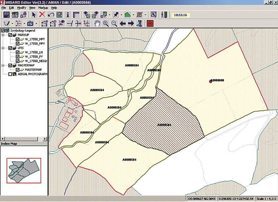
The initial stage involved capturing the various land and parcel data available, using Ordnance Survey Landline data, aerial photographs, and information from the previous year's parcel layer and other reference layers, as well as data for the current year's parcel layer. To capture the data effectively, it was necessary to build a Data Editing System (DES), which was developed with Esri MapObjects as the front end due to its ease of use and its ability to be customized to exactly meet user requirements, whether that be allowing the importation of master map entities, creation of thematic maps, or the ability to display aerial images. DES employed an ArcSDE and SQL Server database at the back end as the latter was already in place at the client site. ArcSDE was chosen because of the necessity to store geometry in the relational database management system. With DES, ARAD was able to see all captured information concurrently and had the necessary editing features at hand. The second stage involved meeting with the owners of each holding during a six-month period to validate the field boundaries drawn in the first stage. ARAD planned to carry out this work using paper maps; after speaking with the farmer, interviewers would mark any changes on the maps with colored pencils and send them back to the office for incorporation into the digital database. After carrying out three test runs, ARAD realized that this system would not deliver the accuracy required or meet the time frame deadline. RMSI, ARAD's partner in developing the solution, had experience in developing software solutions for fieldwork and developed a MapObjects software-based Digital Mark-Up Unit (DMU). MapObjects provided user consistency and the flexibility to enable the creation of necessary marking tools and built-in validation features, and it also provided consistency within the overall project. With DMU, the interviewer could add layers, trace images, add points, and delete parcels and boundaries—and then immediately send the marked-up parcel data to the project team for incorporation into the final database. Following the success of DES and DMU, ARAD was keen to move ahead with its digitization program, which involved development of a three-tier structure representing the central GIS team, divisional teams, and local offices, all connected by a wide area network. ARAD named the system Welsh Information System for Agricultural and Rural Data (WISARD). Key to WISARD was the Work Management System, which guided the entire work allocation and submission by the users, tracking work and delivering status reports. It was built using MapObjects, which was a logical choice given the existing use of MapObjects within the solution and the availability of existing code that could be reused and, therefore, would reduce development time. WISARD incorporated integrity checks on the SQL database using ArcInfo. WISARD required ArcInfo as it provided the topology-building functionality that was crucial to the project. Finally, for the data usage stage, the team created an automated plotting system, again based on MapObjects primarily for cost-effectiveness but also because of the availability of smart custom labeling options. The plotting server allowed users to plot the parcel data for the relevant holding as single or batch plots and enabled the creation of a PDF document, which could then be sent to the client for validation. As a result of the dedicated teamwork, ARAD now has a geospatial system that stores accurate land parcel records and is accessible by various geographically dispersed departments. ARAD reduced the cost of system administration and met its deadline for delivery. What's more, its customers are satisfied with the accuracy of the land parcel data and the increased speed in which claims are settled and payments are made. For more information, contact Ian Storey, WISARD project manager, ARAD, National Assembly of Wales, United Kingdom (e-mail: ian.storey@wales.gsi.gov.uk), or Vikrant Karandikar, senior GIS manager, RMSI, Noida, India (e-mail: Vikrant.Karandikar@rmsi.com). |