Fall 2005
Fall 2005 |
|||||||
|
|
|||||||
Witte Museum Uses GIS to Make a Splash in Its New "World of Water" Exhibit |
|||||||
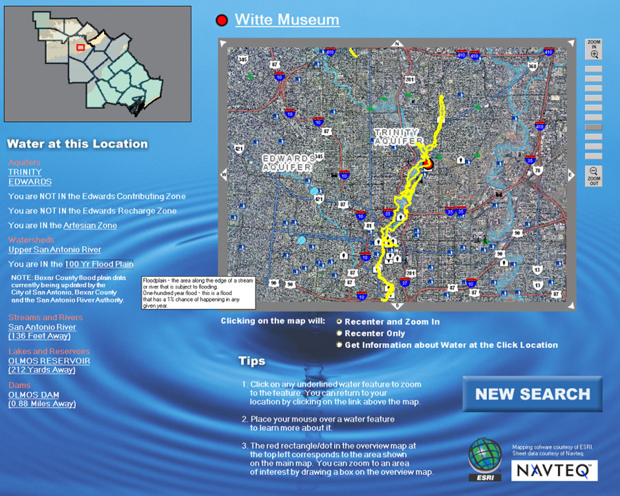
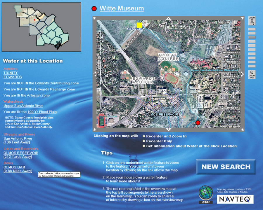
Stretching more than 150 miles from east to west and nearly 100 miles from north to south, the Edwards aquifer is a unique natural resource in south-central Texas, supplying water for agriculture, recreation, wildlife, and the daily needs of nearly two million residents Because this region's climate is semiarid (average yearly rainfall is 30 inches but varies widely from month to month), reliable access to water is critical for sustaining the communities that have grown up here, including San Antonio. Water quality and availability are a primary concern of organizations, such as the San Antonio River Authority (SARA), that have long been engaged in education, preservation, and protection efforts. Recently, the Edwards Aquifer Authority, SARA, the Witte Museum of San Antonio, and a number of other organizations collaborated on an exhibit entitled "World of Water" that was on display at the Witte Museum March through September 2005. The World of Water exhibit comprised several activities, including a 3D virtual tour of the aquifer, a live theater performance in which two raindrops—Splish and Splash—travel through the water cycle, a scale model of a water tower, and a GIS kiosk displaying interactive maps of the Edwards aquifer region. Inspiration for the GIS exhibit came from a 2002 conference about water resources attended by policy makers including former mayors; the Edwards Aquifer Authority; Guadalupe-Blanco River Authority; San Antonio Water System; SARA; University of Texas, Austin, Bureau of Economic Geology; University of Texas, San Antonio, Water Research Center; and other water agencies and advocacy groups. Discussions at the conference led to the agencies deciding that a resource was needed to help citizens learn about their role in maintaining the health of future water in south Texas. Staff members at SARA, who use GIS extensively in their own work, approached the Witte Museum officials, who were enthusiastic and recommended that the museum contact Esri to learn more about GIS and discuss how GIS could be incorporated into the exhibit. Esri-San Antonio staff members met with the museum's exhibit designers to design a user-friendly GIS application to view and analyze watershed information in a way that non-GIS users could readily understand.
In planning the exhibit, one of the themes discussed at length was understanding the watershed. According to Witte Museum President and CEO Marise McDermott, visitors may be aware of things such as water towers or the water cycle but don't fully understand how these things fit together. "We wanted to personalize watershed concepts and help visitors understand the relationship of their property to the watershed," says McDermott. The GIS kiosk helps accomplish this goal by showing individual houses in relation to water features, such as streams, dams, reservoirs, and watershed boundaries. Visitors enter a location—either their home address or a San Antonio landmark, such as the Alamo—and the kiosk displays both a map of the area and a listing of the distance to the nearest stream, distance to the nearest lake or reservoir, the watershed in which the address falls, and the aquifer that underlies the address. In this way, visitors can learn about watershed concepts in a personalized context-for example: What is my watershed? Show me the lake where I go fishing. The GIS kiosk was built using ArcGIS Engine and a data library of more than one terabyte of spatial data from a variety of sources managed with ArcSDE. Esri-San Antonio staff built the application in consultation with staff from the Witte Museum and SARA over a period of three weeks. One of the highlights of the exhibit is the full-color aerial photography at six-inch resolution from the city of San Antonio. This level of detail enables visitors to clearly identify their house and the water features that surround it. "It's sensational," says Lisa Apolinar, a visitor from San Antonio. Another visitor, David Espinoza, comments, "The exhibit provides really good information. My wife and I didn't know about the 100-year floodplain."
Additional data for the application was provided by NAVTEQ; SARA; and the Texas Natural Resource Information System (TNRIS), which provided the street maps. A number of partners, including the Guadalupe-Blanco River Authority, collaborated on a 64-page booklet of curricular materials to accompany the World of Water exhibit, which is distributed on CD to schools that are planning a visit to the Witte Museum. The booklet includes both previsit and postvisit activities that enhance the learning experience by providing background materials to help students understand what they will see, as well as providing an opportunity for students to apply what they have learned in their own neighborhood after the visit. The Witte Museum hosts 80,000 schoolchildren per year from south and central Texas. The entire World of Water exhibit is a prototype for a new Water Resource Center that will become a permanent part of the Witte Museum campus. Activities are being developed and tested in the prototype space, and the most popular and successful activities will be transferred to the new center. For more information, contact Jim Dalglish, Witte Museum (tel.: 210-357-1870, e-mail: jimdalglish@wittemuseum.org, Web: www.wittemuseum.org). |