Fall 2007
Fall 2007 |
|||||||
|
|
|||||||
ArcGIS Server Delivers Geographic Intelligence Across the Enterprise
Fulfilling the Promise of a Complete Enterprise GIS |
|||
Highlights
Extracting data and building innovative tools does little good if no efficient means of distributing these solutions exists. The end result of a GIS department's labor only has value when put in the hands of those who need it most—specifically, workers across the enterprise and the public. ArcGIS Server is the critical piece that makes the efficient flow of geographic information to the end user possible. By implementing ArcGIS Server, GIS departments can maintain centralized management of GIS data and processes while at the same time empowering their constituents to obtain and share the geographic data and tools they need to do their work. ArcGIS Server has given rise to the "author, serve, use" paradigm. GIS professionals author GIS content and capabilities using ArcGIS Desktop and publish them to ArcGIS Server. From ArcGIS Server, authored content is served out to those who need it. The end user can utilize these authored services in desktop applications, browsers, or mobile devices. Moreover, ArcGIS Server gives users the ability to edit the data, which can, in turn, be shared with other end users, thus creating a common operating picture. With this two-way flow of information, everyone has access to the most current data in near real time. ArcGIS Server is an open, flexible, and scalable technology that runs on an industry-standard IT infrastructure and supports geospatial service-oriented architecture (SOA) initiatives. ArcGIS Desktop software complements ArcGIS Server by acting as a means of authoring, configuring, and maintaining data, models, and applications. With the addition of an integration platform, GIS services, such as mapping, geocoding, geoprocessing, and data management, can be fused with other shared services of complementary enterprise systems (e.g., customer relationship management [CRM] or enterprise resource planning [ERP]). Three Core Features
More InformationFor more information about how ArcGIS Server improves workflows, read the following articles and poster.
|
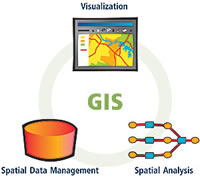 What makes ArcGIS Server a unique, out-of-the-box solution are its three core features: comprehensive management of geographic information, powerful visualization, and enterprise spatial analysis: