Fall 2007
Fall 2007 |
|||||||
|
|
|||||||
People–Nature: The Natural Network |
||||||||
|
By Michael Gallis, Gary Moll, and Heather Millar
On a warm August day in 2004, Jim McGreevey, then governor of New Jersey, climbed the wall of the Wanaque Reservoir, part of a network of holding pools and aqueducts that flows from the northwest, supplying drinking water to the suburbs that ring New York City, New York, and Philadelphia, Pennsylvania. There, flanked by well-wishers, publicity handlers, and lawmakers, the governor signed legislation aimed to protect hundreds of thousands of acres in the Highlands, perhaps New Jersey's last large, intact ecosystem.
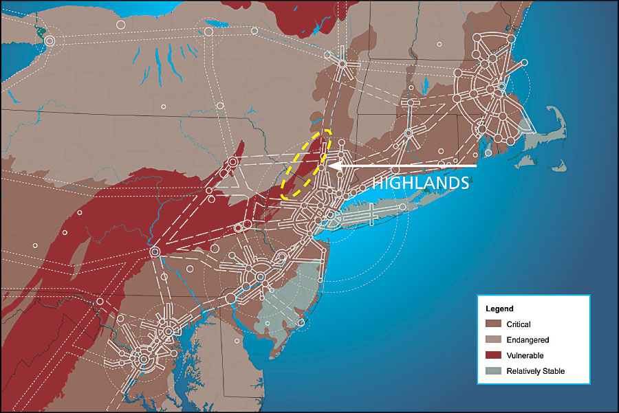
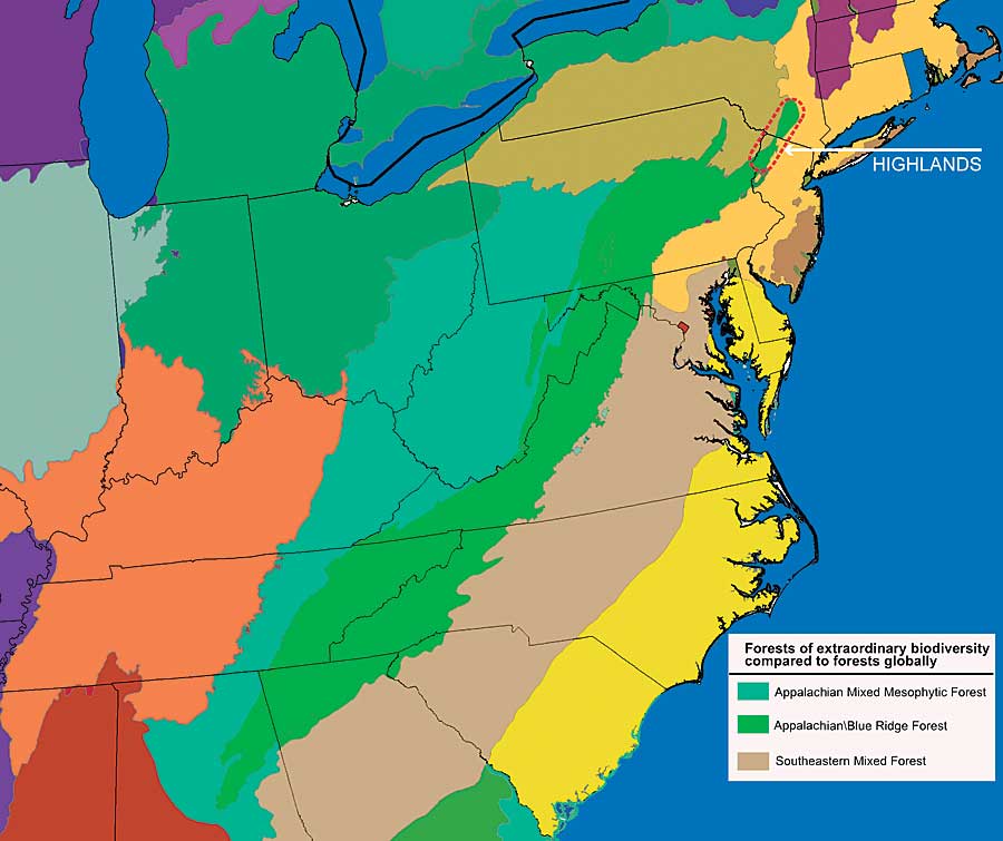
"The Highlands has been one of the missing jewels . . . in our preservation efforts . . . ," McGreevey said. "Today is a wonderful day . . . for our environment and our children." Meanwhile, many of the state's foremost environmental leaders—the executive directors of the state chapters of the Audubon Society, the Sierra Club, and many others—boycotted the dam event. Concerned by the signing of a bill that could "fast track" development in other parts of the Garden State, the "greens" held a competing press conference and went hiking in the woods. The hardwood forests of the Highlands where the activists walked that day stretch for nearly 3.5 million acres, over folds of gneiss and granite that undulate north from Pennsylvania, through New Jersey and New York, to Connecticut. This world, occupied for now by the bobcat, black bear, bald eagle, and about 3,000 other species, plays a key ecological role within North America. In the Highlands, several continental-scale ecoregions come together: Here, the Appalachian/Blue Ridge ecosystem that reaches up from Alabama and Georgia ends, mixing with northern ecologies. In this transition zone, the plant and animal species from north and south meet and mix. Ecosystems and species occur here that exist nowhere else. The Highlands, covered with oak, hickory, and ash, or hemlock and red maple in moister spots, provides an important way station for birds migrating up from Central and South America. Warblers, vireos, tanagers, and dozens more stop over here. The Highlands houses more than 300 plant and animal species that the U.S. Fish and Wildlife Service judges of "special emphasis." These hills contain some of the richest ecological communities on the continent: their biodiversity rivals that of the Florida Everglades. While lesser known, the Highlands is even more threatened than Florida's beleaguered wetlands. In part, this is because these low mountains form the backyard of the urban Northeast: More than 15 million people live within one hour of this patchwork of glacial lakes, wetlands, and forested valleys. Each year, more people visit the Highlands for outdoor recreation than all the visitors to Yosemite, Yellowstone, and the Grand Canyon combined. "We don't have the luxury of time in the Highlands," Jeff Tittel, the state's Sierra Club director, has told the press again and again. Nearly everyone—farmers and politicians, developers and ecologists—agrees that the Highlands is important, especially in a state that gets the majority of its drinking water from small rivers that originate in these low mountains. Arguments about preserving the Highlands began almost a century ago. In the last two decades, the debate has grown more strident and polarized: the defenders of private enterprise and property rights on one side, the opponents of sprawl on the other. Really, both sides are right: New Jersey needs key swaths of the Highlands to remain wild. New Jersey also needs affordable homes. In the Highlands and across the country, these competing goals must somehow be reconciled. Yet this will never happen unless voters, businessmen, politicians, and other leaders fundamentally change how they perceive problems like species extinctions, air and water pollution, urban sprawl, global warming, and dwindling resources. Three years after the ceremony at Wanaque Reservoir Dam, the future of the Highlands is far from clear. The state bill remains underfunded: State lawmakers set aside $500,000 for Highlands preservation in 2005 and 2006. However, the Regional Plan Association, a nonprofit organization dedicated to improving life in New York, New Jersey, and Connecticut, says as much as $1 billion may be needed by 2014 to save critical parcels.
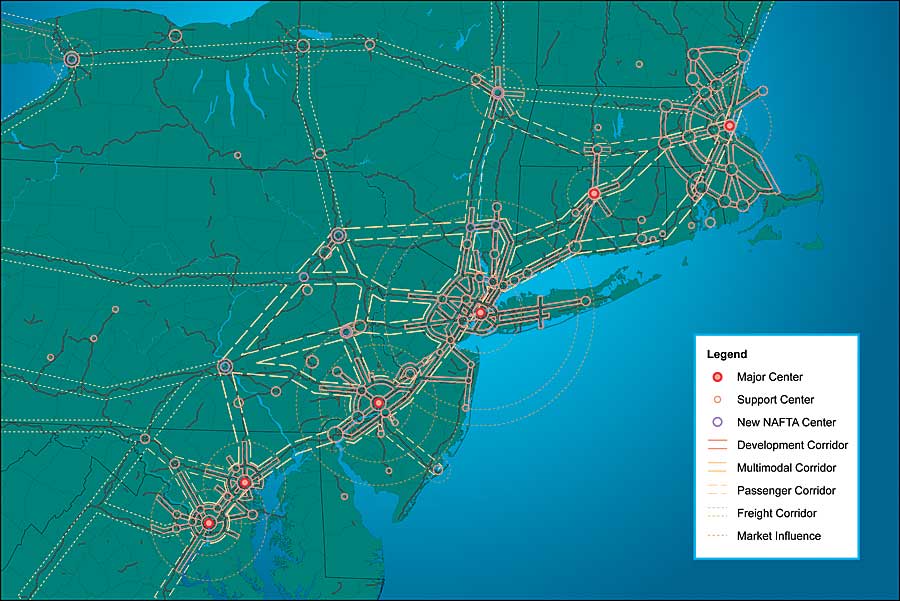
Lack of money may be the most obvious problem. But these budget shortfalls would not be tolerated if not for something that threatens the Highlands even more: lack of vision and understanding. If we're going to save the Highlands, or any other threatened ecosystem in North America, we need a fundamental shift in perception. We need to place these regions in their larger contexts, to recognize that they are not islands. How does the Highlands fit into the continent's ecology? How do regional and continental human systems—roads, real estate, economic corridors—overlay the natural systems? These sorts of big-picture questions are missing from the dialogue. Though more than 150 environmental groups have joined the Highlands Coalition—a group of organizations fighting to preserve the region—and dozens of scientists are studying the ecosystems and impacts of development there, none of these efforts takes on the region's natural and man-made systems as a whole. None examines how the region might work as an integrated system, both ecologically and economically. Studies of environmental impacts examine problems species by species, place by place, or problem by problem. They form a patchy mosaic of information, not a coherent scientific picture. Even the Highlands Coalition divides its efforts by state. Development, while mapped by region, is approved and funded one project at a time. Yet the Highlands desperately needs an overarching vision: More than 80 percent of the critical open land in the Highlands is already fragmented into private parcels and thus more vulnerable to development. Meanwhile, the Highlands' population is growing 50 percent faster than the statewide rate, according to the state Department of Environmental Protection (DEP). A Forest Service study has shown that each year, 5,000 acres of the Highlands succumb to bulldozers. The suburbs loom ever closer. What's most needed is a framework that ties together all these well-known challenges. We need to do more than decry sprawl or fret about new condos and toxic runoff in the Highlands. We need to understand how human systems fit into the Highlands' natural pattern of wildlife and water flow, and so on. We need to analyze the economic, social, and transportation patterns that encompass the region. How do these human activities in the Highlands connect to other parts of New Jersey and beyond, to other states and to other countries? A New Framework: Nature and the NetworkAs we've outlined in previous articles, we believe that the global network is the most useful framework for understanding the pressures on ecosystems and human systems around the country and around the world—including New Jersey's Highlands. While infinitely complex in its details, the network is really a simple idea: It's the patterns of trade, transportation, and information that people use to meet their needs—roads, shipping routes, economic regions, digital systems. This network forms a pattern of centers and corridors that reaches around the world like a web. Looking at the world this way makes it possible to break down problems and start to identify goals and strategies. In the Winter 2006/2007 issue of ArcNews, American Forests, in partnership with Michael Gallis and Associates, explained how this new vision has transformed regional plans in North American cities like Memphis, Tennessee, and Cincinnati, Ohio. In the Summer 2007 issue of ArcNews, we explored how the network in the Northeast has evolved: changing from rural landscape to the well-known corridor traveled by Amtrak trains to the bull's-eye patterns of late 20th-century, metro ring roads. Today, the network has begun to form a new pattern: a lattice of transportation and economic nodes that reaches westward. We believe that seeing and understanding the network could lead to effective ways to integrate human systems and ecosystems in the Highlands and elsewhere. If we see the problems in a new way, the Highlands could be a hopeful example of how we can manage growth. How the Network Covered New JerseyMillennia ago, the network began as simple trading paths. Over the centuries, it evolved and became stronger and more complex: Trails turned into roads. Roads led to ports and shipping routes. Later, trains, planes, spacecraft, and digital technologies added new layers to the network's web. While the network has always impacted the environment, it's only in the last 50 years that it has become so powerful and widespread that those environmental impacts have threatened human society. Suburban New Jersey—the ring communities around New York City and Philadelphia and the nether regions in between—has been battered by these problems. It's a poster child for the problems of network growth: five federally endangered species have become extinct in the state, wetlands have been filled in, forests have been cut, groundwater pollution has increased. Unplanned development has continued until the state DEP has warned that New Jersey could run out of drinking water by 2040. We find it useful to think of five major environmental impacts of the human network:
The Network Pressures the HighlandsDevelopers in the Highlands like to defend their plans for a new golf course or condo complex by pointing out that the forests that now cover the northwestern part of New Jersey are hardly untouched wilderness. Dutch settlers first came to these hills and narrow valleys in the 17th century. They, and the Scots and Huguenots who followed, created a patchwork of fields, forest, and compact villages. When high-grade iron ore was discovered, the farms gave way to mines. Ore from the Highlands provided metal for the cannonballs used in the Revolutionary War. By the 1830s, most of the region's trees had been cut down to feed the iron-smelting furnaces. Almost no native animals remained. By the late 1800s, the sighting of eight deer in the Highlands made front page news.
Yet these depredations did not totally destroy the Highlands. Gradually, people turned their attention elsewhere. A few farms held on, but the rough, craggy terrain discouraged large-scale urbanization when so many easier places still hadn't been developed. The forest grew back over the last century or so, again providing key habitat for 150 kinds of birds, as well as endangered species like the woodland turtle, timber rattlesnake, and woodland rat. The full force of the human network did not reach into the Highlands until the early 1980s, when the completion of Interstate 80 opened up an east–west corridor through the region. Suddenly, the trip from Parsippany, then a bucolic little town at the foot of the Highlands, to Manhattan dropped from more than an hour to about 30 minutes. Soon after, Interstate 78 opened another east–west corridor to the Bethlehem, Pennsylvania, area. As the 1980s progressed, campus-style offices followed the subdivisions. Multinational corporations built headquarters in the Highlands and helped fuel New Jersey job growth during the slump of the late 1980s. Then Interstate 287, running north–south, connected I-80 and I-78 in 1993. Suburban-style development marched into the Highlands. In the early 1990s, a study by the Forest Service sounded the alarm about the Highlands, calling for a regional planning authority and warning that unchecked development could threaten water quality, wildlife habitat, and recreational resources. In reaction, the state took steps, mostly buying up parcels around the large reservoirs. The Forest Service updated its report in 2003, again issuing warnings and identifying 100,000 acres of prime Highlands forests, watersheds, and wildlife habitat that were in danger of being lost to development. The Forest Service also found that 25,000 acres of forest had been lost between 1995 and 2000. The bill signed atop Wanaque Reservoir Dam on that summer day in 2004 has by no means "saved" the Highlands. The Regional Highlands Planning Council doesn't have enforcement authority, and green groups worry about a recently signed fast track bill that requires any permit not acted on within 45 days to be automatically approved, and there's disagreement about whether this bill applies to the Highlands. A New ProcessObviously, what we're doing in the Highlands isn't working. The development that now threatens the Highlands is different from the extractive industries that rolled through the region in the 18th and 19th centuries. Loggers and miners may have devastated the Highlands, but they left the ground open. Eventually, it regenerated. Modern development paves over natural regions with asphalt and lawns, subdivisions, office parks, and malls. That will entirely upset the Highland's ecology, changing soil chemistry, plant cover, and all the natural processes that make the Highlands work both for wildlife and for humans. "Habitat is being altered so fast and so thoroughly that we have no idea what's happening to many species," says Emile DeVito, manager of science and stewardship for the New Jersey Conservation Association. We need a new process, a new perception of the dangers and the possibilities. First, people need to understand how the Highlands fits into the global network. Those on both sides frame the debate as if the Highlands were on the edge of ever-expanding circles of development reaching out from Philadelphia; New York; and Hartford, Connecticut. Actually, the Highlands is not on the edge. It's in the middle, both ecologically and economically. The Highlands occupies a swath of territory that crosses the lattice developing between these reenergized cities to the west and, to the east, the metro centers from Washington, D.C., to Boston, Massachusetts. Development is not only spreading west from the big cities, it's spreading east from smaller centers like Scranton, Pennsylvania. It's as if the Highlands is caught in a nutcracker. Rather than fighting these developments, we could have predicted them if we had looked at the Highlands in the context of the network. Yet, like generals fighting the last war, politicians and planners have in the last two decades focused on the sprawl emanating from New York and Philadelphia. They failed to recognize the importance of Interstate 81, an inland parallel to the coastal Interstate 95. They failed to appreciate the impact of Interstate 78, which links New York to Bethlehem-Allentown, Pennsylvania. If expansion of the human network is inevitable, how do we manage its impact? We must bring all parties to the table to discuss this question. For example, the New Jersey Builders Association is concerned that preservation plans have not put the Highlands in the context of regional economic activity. It's a criticism worth pondering. Then again, while the nonprofit Highlands Coalition's Critical Treasures report tried to take a more regional view and identify key ecosystems in the Highlands, the region still has no federal designation or protection that would allow preservation on a regional level. Efforts to protect the Highlands are divided into dozens of groups and municipalities. These efforts should be brought together. It bears repeating: it would help if everyone sat down and tried to figure out how the human network can move through these beautiful hills without destroying them. If the species and ecosystems disappear in the Highlands, what will replace them? How will the quality of all life support systems suffer? How do these species and ecosystems fit into the larger tableau of North America? Beyond supplying water, what is the ecological function of the Highlands? These are the questions that policy makers and developers should be asking and answering. Concern and ResourcesWhen Michael Gallis and Associates (MGA) has consulted in cities like Memphis; Orlando, Florida; and Cincinnati, we brought all interest groups together. Then we divided human society into areas of concern and resources. We used nine categories:
Taking one category at a time, we asked these kinds of questions: What economic and social patterns are driving the development of the region? Where are the transportation corridors? Where are the economic corridors? What metro areas are nearby? How are they linked? How is expansion and change happening? While it's not usually brought together in this macro way, the data to answer these questions is out there: in government databases; GIS databases; and academic atlases of soil, geology, vegetation, and animal life. GIS technology can read these complex sets of data and create maps on the fly. Software like American Forests' CITYgreen can model how air and water move through these ecosystems. We can create trend diagrams that model how human activity and natural systems may evolve in coming decades. Eventually, we can create two sets of diagrams: one that outlines the human network and one that describes the natural systems. Then we overlay the pattern of the human network over the pattern of ecosystems and ask: How can the natural environment fit into regional patterns and resources? How can the environment enhance the economic goals of the region? Seeking these diagrams and asking these questions must be an ongoing process. Apply This Process ElsewhereYes, environmental and economic development issues are complex. But using this process to break down problems and devise strategies has worked in Rhode Island and Memphis, Tennessee; Orlando, Florida; and Cincinnati, Ohio. Together, MGA and American Forests will make the process work better: MGA brings strategic planning expertise to the table; American Forests examines the environmental systems with more intensity. It can work in the Highlands and across the rest of the country as well. About the AuthorsThis is the third and last in a series of articles focusing on the need for decision makers to understand that nature and humans must work together. Gary Moll is the leader of the Urban Ecosystem Center at American Forests, an Esri Business Partner. The center has conducted ecosystem analysis on more than 40 metropolitan areas. Michael Gallis is a member of the board of directors for American Forests and a strategist and principal of Michael Gallis and Associates, a strategic planning and design firm in Charlotte, North Carolina. Heather Millar is a Brooklyn, New York-based writer who has written for many magazines, including the Atlantic Monthly, National Wildlife, Sierra, and Smithsonian. More InformationFor more information, visit www.americanforests.org, then click on "Learn More" under the globe. See also the two previous articles: |