Winter 2006/2007
Winter 2006/2007 |
|||||||
|
|
|||||||
Nature, the Human Network, and the Role of GIS |
||||||||
|
By Gary Moll, Michael Gallis, and Heather Millar
The environment is a seamless, interactive system that wraps the earth. At some level, everyone understands that what happens on the land affects the health of the air, the waterways, and so on. Amazingly—since we all intuitively understand that the environment is a system—business, government, and even watchdog groups have never truly addressed the environment this way. Business has seen the environment as a resource. Government has tried to create legal frameworks to manage its use. The activist community has tried to protect it. Because of their conflicting goals—development versus protection—businesses and activists have approached environmental problems from opposite directions. Government actions have ranged widely, depending on the political climate, from laissez-faire to inflexible regulation. The outcome is a piecemeal, ad hoc, and inconsistent environmental policy. Whether these actions have involved setting aside wilderness, protecting endangered species, or regulating air and water quality, all efforts to minimize environmental damage have been split up into a crazy quilt of separate projects and problems: this endangered species, that critical place, this pollutant, and so forth. People-Nature: A New FrameworkWe at American Forests, the nation's oldest citizen's conservation organization established in 1875, believe that we need to try to begin to fit these pieces together within a common framework. People must find the means to rebuild and reconnect the fragmented parts of the environment. The environment is not the problem. Humans are the problem. How we create a framework for development, or don't, is the problem. Unless we all begin to approach the environment as a system, we will not preserve it. Unless we try to solve environmental challenges within the context of a system, we will only address part of the problem. In the face of inevitable, continued urban and economic development around the world, such partial solutions will be disastrous. Unless we create a new framework that includes the environment and guides the growth of our cities and our economy, we will destroy the environment. If we cripple nature, then we also lose our prosperity and all that goes with it. This new framework needs to be built on the understanding that the environment is a living system, continuous and interactive. Building on this idea, we need to treat nature as a system and maintain it like all the other systems we manage: urban systems, transportation systems, economic systems. Over the next year, American Forests hopes to sketch out how this new initiative and new framework can grow from a new public, private, and institutional coalition. We hope to explain why this coalition must embrace the environment as a living, planetary system. We hope to suggest ways that communities, industries, business, and government can come together to devise systemic solutions. We believe that GIS data and companies can be integral to fashioning system-based solutions to our environmental challenges. A broad coalition can begin this initiative, but we hope to make clear that only a more active and informed federal leadership and framework can achieve this goal. American Forests played a central role in 1905 when Teddy Roosevelt formalized the federal government's involvement in the conservation movement, and we hope to play a similar role as we move forward with the building of the new framework for the environment/network. Humanity and Nature CollideThe need to reach out for new forms and new solutions has never been more critical. Within the next few years, more of humanity will live in cities than in the countryside; we will become a predominantly urban species. The United Nations projects the world population will be nearly nine billion by 2050, and the demand for resources is projected to increase from 400 to 700 percent its current level (according to the Goldman Sachs Group, Inc.).
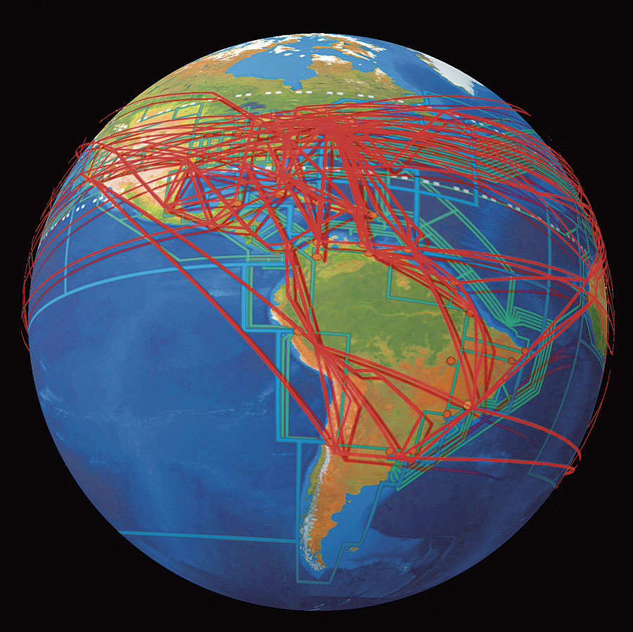
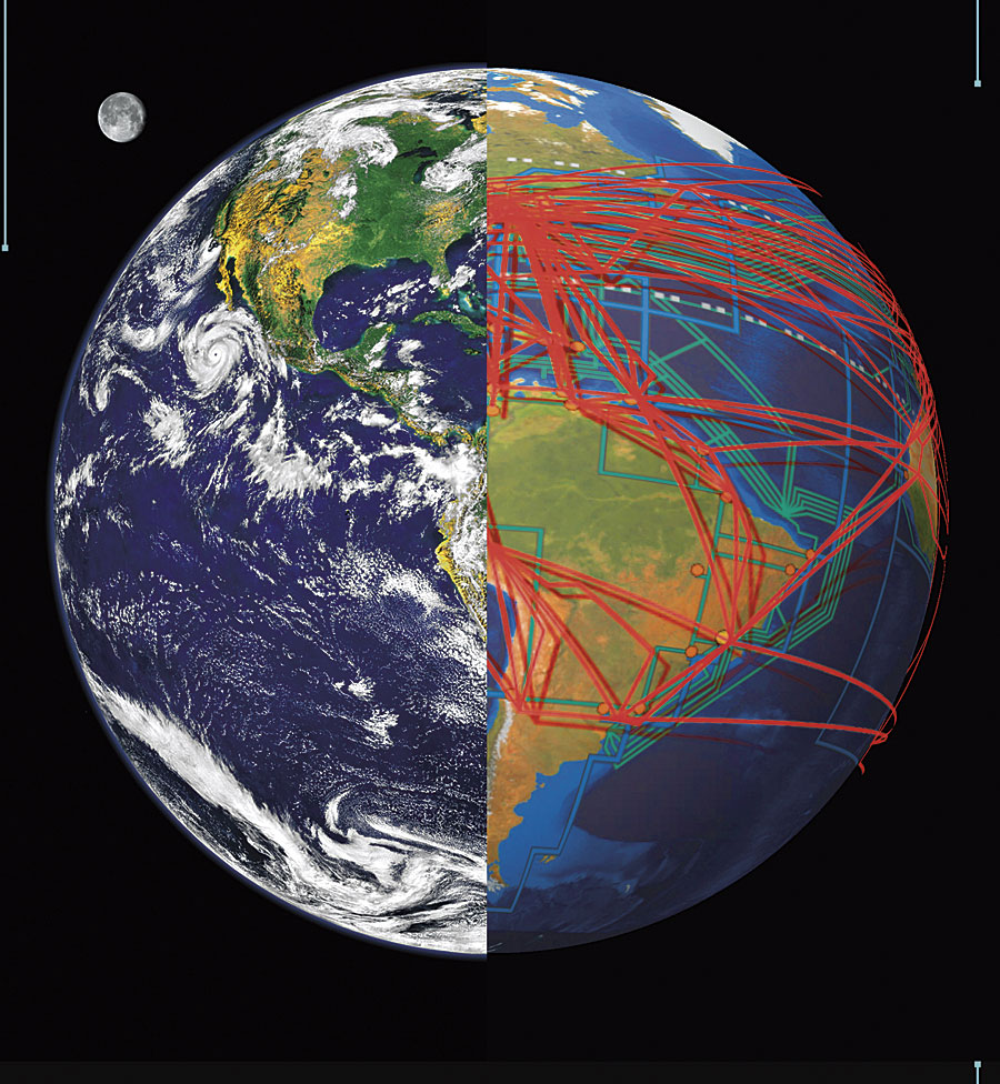
At the base of every environmental issue, every local leader's quandary—whether it's tree canopy, water pollution, biodiversity, or invasive species—lies a fundamental competition and collision between two systems, between two "networks": the natural network and the human network. When forests and other resources seemed limitless, we didn't need to think or work within a framework that balanced and integrated the needs of both systems. We just planned and constructed our cities, our industries, and our transportation networks as we pleased. Human networks—cities, roads, and businesses—could occupy separate territory. We could delude ourselves that nature was "out there," somewhere else, in a park or remote wilderness. Yet today, the conflict between man and nature is becoming impossible to ignore. Consider that the Chicago suburbs provide habitat for more threatened species than any other area in the state of Illinois. The world economy is growing at an astounding rate. According to World Bank figures, the economy reached $30 trillion in annual value by the year 2000. Just four years later, in 2004, that figure had soared to $41.6 trillion. Economic growth is beginning to outstrip population growth, creating a conflict between humanity's desire for the "good life" and nature's ability to support it. Megacities, like New Delhi, India; New York City, New York; and Sao Paolo, Brazil, expand on every continent, strengthening their connections to each other and thereby improving their ability to obtain the resources they need and want. Urban regions demand more food, more cars, more housing, more furniture, and more concrete and asphalt as their populations grow. Satisfying these demands requires that vast amounts of raw materials and manufactured goods be pulled through a giant global network that reaches into ever more remote parts of the globe. Think of this network as the summation of all the things that move people, goods, and information around the world. It's the foundation of civilization. We talk about the physical parts of the network all the time: the Internet, the phone system, the transportation system. But we seldom think of the network as a totality, as the physical and technological means by which globalization occurs. It is not the physical infrastructure of roads, shipping lanes, and airlines that is the most important to consider in this case. What most impacts the environment is the vast stream of resources and products that travel through these avenues of commerce: plates and silverware and animal carcasses and oil. When the world was divided between the Communist and free world blocs, human networks were also divided. Now, since the collapse of the Soviet Union, the network has reunified and is becoming truly global. It wraps the entire planet like a giant spider web—obvious to see from any large-scale GIS image. It is precisely because this network appears so mundane, so ordinary that it remains largely invisible and entirely misunderstood. Most people don't think of the world in these terms. Environmentalists don't know how to approach the network and tend to see everything associated with it as a problem. Business and political leaders see only the part of the network that affects whatever their interest happens to be at a given time. We must integrate the network into our thinking about people and nature. This is urgent because across the world our exponentially increasing demand for nonrenewable resources decimates natural areas. Nationwide in the United States, only 6 percent of the once vast, old-growth forests remain, for example. In addition, timber companies are clear-cutting huge swaths of the Canadian Rockies.
In Atlanta, Georgia; Chicago, Illinois; Los Angeles, California; Memphis, Tennessee; Orlando, Florida; and other urban regions, the expanding network is leading to greater urban sprawl. As regions grow, they erode the natural landscape. East of the Mississippi River, urban areas have lost 30 percent of their tree cover, according to American Forests' Urban Ecosystem Analysis (UEA). The association has conducted UEAs in more than 40 metropolitan areas in the United States. The analysis combines remote sensing, GIS technology, and ecological modeling to calculate changes in land cover over time, as well as determines the financial impact of these changes. Sadly, because of the way our business and political institutions are set up, most places do not embrace regional, systemic planning that effectively reconciles the needs of both humanity and nature. It Doesn't Have to Be This WayYet, in many quarters, there is a growing recognition that we've got to try to do things differently because business as usual isn't working. Consider, for instance, that municipalities nationwide now quite commonly band together in regional associations rather than laboring alone on problems like transportation or air quality. While most of these groups lack enforcement power, and many are plagued by internal disputes, at least they are trying to start some sort of regional dialogue on issues of common concern. See Systems, See SolutionsPlaces that have begun to recognize human systems and ecosystems are crafting creative solutions to their problems. In the Cincinnati, Ohio, and Memphis, Tennessee, metropolitan regions, leaders are developing strategies that reach across three states. In the Orlando, Florida, area, an online framework—Myregion.org—allows 150 communities across seven counties to work together on a variety of issues. As they have worked together, Florida leaders have begun to understand that Orlando's environment is also part of a natural network, a global ecology. Central Florida is flat and not as scenic as, say, Boulder, Colorado, or San Francisco, California. Yet the Orlando area is unique and has tremendous ecological importance: it is the only place in North America where tropical ecologies overlap with temperate ones. Hidden in all that flatness and in the murky swamps and estuaries, incredible biodiversity thrives: more than 400 species in the Indian River Estuary alone. Orlando leaders began to recognize that preserving this natural richness was inextricably linked to creating value in real estate, creating ecotourism businesses, and building the rest of the economy. Policy makers slowly learned to stop thinking of the environment simply as a new park or nature area and to see it as a continuous system woven into their region. As a result, they began to link the region's growth to the environment, form a more integrated strategy that takes into account all the swamps and rivers, and publicize the region as a birding destination. Indian River Estuary birding ads now appear in magazines like Sierra and Audubon. In Cincinnati, the idea of linking human systems and natural systems inspired leaders to create a vision much larger than a downtown riverfront park. They embraced the concept of a 160-mile-long environmental corridor along the Ohio River. In Rhode Island, Kip Bergstrom, the executive director of the Rhode Island Economic Policy Council, is leading an initiative to preserve the "Gap," the last large tract of natural landscape in the Northeast. Bergstrom and other leaders believe in the Gap's value for the state and for the region. In the West, a coalition of nongovernmental organizations has conceived of a regional system on a grand scale: a network of wildlife corridors connecting the large wildlife parks and reserves that already exist, stretching nearly 2,000 miles from Wyoming's Yellowstone National Park to Canada's Yukon Territory. As imagined, the Yellowstone to Yukon (Y2Y) Conservation Initiative would create an "animal superhighway," a wild heart of North America where grizzlies, wolverines, redband trout, and other threatened species could skirt developed areas and coexist with human settlements and industries. The Y2Y initiative has made some headway in realizing its vision. Some 16 million acres of the Muskwa-Kechika Management Area in northeast British Columbia have been protected from development. Work is under way to restore and maintain wildlife corridor connectivity across the Trans-Canada Highway in Banff National Park. The Y2Y initiative also focuses on supporting scientific research and gathering data—much of it GIS data—to support its efforts. A sleepy Seattle suburb just a few decades ago, Bellevue, Washington, has grown to be one of the largest cities in the state, with its own soaring skyline and a business community anchored by technology giants, such as T-Mobile and Expedia. But it's also a place that people call "a city in a park." It's a place that has managed to keep chinook and sockeye salmon running through suburbia; created wildlife corridors through the subdivisions; and preserved 2,500 acres of forest, wetlands, bogs, and parks within a stone's throw of the skyscrapers. In some of the city's watersheds, one-quarter of the land remains wild. There, the otter, beaver, coyote, and osprey go about their lives with the soft hum of urban life in the background. Bellevue has embraced GIS to better reconcile man with nature. For example, the city is teaming up with nearby communities to acquire advanced satellite data that will enhance the GIS data that the cities already use. This enhanced GIS data will make it possible for planners and developers in several municipalities to quickly calculate what percentage of a watershed is covered by asphalt or to see how natural systems, such as forests, flow through their communities. People often argue that human society and the environment are too big, too mutable, and too complex to be planned as systems. Of course, local planners and leaders don't know, and can't do, everything. But together, people have made a start. Once the environment is seen as a system, big things begin to happen. Leaders and citizens start to see that they can make a difference. Time to ActGIS technology is part of the story in every successfully growing region of the country, and it can be the cornerstone for building the "new framework" in your region with your help. The two fundamental elements for building a new framework are visualizing your region or place and analyzing the systems at work in that area. There is a third step to be touched on last. Your action as a GIS user is the critical first step. To start building a new framework, you need to first answer the question, Where? Your region needs to be defined, and thinking of the region in connection with a metropolitan area will likely be the most useful. This is done by creating a project in ArcGIS that identifies the metropolitan region where you live. It needs to encompass major natural areas, like watersheds, and will include several smaller cities and towns. For example, the Cincinnati region stretches into three states while the region around New York City consists of five subregions (Connecticut; Long Island, New York; New Jersey; and New York City, New York). The metropolitan area will range in size from a couple hundred square miles to more than a thousand square miles depending on its location and the size of the systems involved. It is not critical that you identify the regional area of interest (AOI) perfectly the first time you outline it (make a shapefile) but, rather, that you create a palette for visualizing the systems that form the framework for your region. Step two is to find the data that identifies the systems that make up the region. This is where your knowledge of the technology and the data sources is paramount. You need natural system data that identifies the land, water, and air systems as well as the elements of the built network, like transportation, education, medical resources, culture, and governance, to name a few (the full list is available at www.Americanforests.org). You will find some data ready to use (e.g., see "ArcGIS Online Services Introduced") and available over the Web. We suggest using it when possible so that the procedures you use in your region can be easily shared with users in other regions. The third and final step requires you to step away from the computer and the GIS procedures and introduce decision makers to your project. The local leaders that need to work with the project you have started reach well beyond the elected officials and must include members of business and industry. A good place to start is an area or regional chamber of commerce. Take your project to the chamber and have a workshop where members of the chamber can see the region you have identified and can ask you to run scenarios. We need to build a new framework that weaves nature and the network together starting today. GIS users need to play a central role in this effort. It should be obvious to all thinking people that the capacity of natural systems, which make this a living planet, cannot sustain the growth of the network over the next 40 years. We have provided a recipe for you to start building the new framework in your region; we look forward to joining you in this effort. About the AuthorsGary Moll is the leader of the Urban Ecosystem Center at American Forests. The center has conducted ecosystem analysis on more than 40 metropolitan areas. In 1996, the center produced CITYgreen software to assist GIS users in analyzing their local ecosystems. Michael Gallis is a member of the board of directors for American Forests, an Esri Business Partner, and is a strategist and principal of Michael Gallis and Associates in Charlotte, North Carolina, a strategic planning and design firm. Heather Millar is a Brooklyn-based writer who has written for many magazines, including the Atlantic Monthly, National Wildlife, Sierra, and Smithsonian. More InformationFor more information, visit on the Web www.americanforests.org.
|