Fall 2008
Fall 2008 |
|||||||
|
|
|||||||
GIS Enhances China Relief Efforts |
|||||||
Highlights
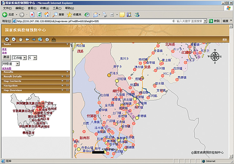
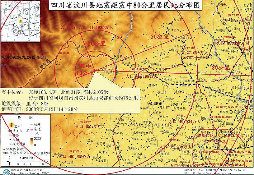
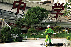
On May 12, 2008, an earthquake measuring nearly 7.9 struck Sichuan Province in southwestern China. It was the country's worst natural disaster in more than 30 years. Roads cracked; buildings burst; and terrible destruction resulted in approximately 70,000 killed, 20,000 missing, and more than 5 million homeless. For the GIS community, it was a rallying point. GIS professionals from numerous countries not only contributed financial donations to relief organizations but also traveled to the area to offer computer mapping support. Esri launched a disaster support program to provide software to responding agencies and individuals as well as access to disaster application materials, literature, demos, and more. In addition, Esri China (Beijing) Limited donated money, software, and staffing. A GIS volunteer program was put into place to help GIS professionals support earthquake-related tasks. By May 30, there were more than 450 GIS volunteers enrolled. And dozens of them were working with the China Earthquake Administration (CEA), the Chinese Academy of Sciences (CAS), the Chinese Center for Disease Control and Prevention (China CDC), and many other organizations. In addition, Esri collaborated with more than 20 technology companies, including Hewlett-Packard; Trimble Navigation Ltd.; and Esri China's business partners, imagery vendors, and data suppliers, to support the Chinese government agencies. "Our deepest sympathies go out to the Chinese people and those affected by this terrible event," says Jack Dangermond, president, Esri. "Esri China, along with Esri teams in Redlands, California, and many GIS organizations and individuals, worked diligently to support the rescue efforts headed by the CEA and other agencies in the disaster area. Their work was important and made a difference in the immediate rescue and relief efforts. It's going to continue to help in long-term recovery, with GIS professionals working to rebuild communities and help people." "GIS gives you a very good visualization method to know what is happening in real time," says Francis Ho, president, Esri China (Beijing). "GIS also provides tools to better analyze large volumes of complex data. Immediately following the earthquake, we worked on a continuous basis with government agencies and others to offer assistance wherever we could. We will continue to support the long-term recovery. The work being done with GIS is helping to reduce the impact of this large, complex disaster." China Agencies Respond QuicklyChina CDC took advantage of Esri staff and volunteers to develop an epidemic monitoring and reporting system using mobile phones. ArcGIS Server, ArcInfo, and the ArcGIS Spatial Analyst and Tracking Analyst extensions were deployed to track disease incidents and their spread. Staff would go to various clinics and medical facilities to collect data, using GPS-enabled phones and devices that could wirelessly transmit data tied to locations back to the primary epidemic tracking system. The CEA, tasked with capturing and disseminating seismic information, deployed Esri technology, including ArcIMS and ArcSDE, to launch an official Web site that can be viewed by both the public and government officials (www.ceic.ac.cn). This provides a more effective method for transmitting data. People can simply open up their desktop computers, wireless laptop computers, Web-enabled phones, or other mobile devices to view spatial data as it is being collected and published by the CEA. The Ministry of Civil Affairs—Disaster Reduction Center requested that Esri China engineers come on-site to support imagery and data processing as aerial photos and remotely sensed data depicting damage assessments and road collapses came into the center. Esri and Esri China staff, along with alliance members, help manage databases and integrate information into a single, complete picture. Staff then decide what relief workers and supplies should go to specific areas.
The Ministry of Civil Affairs—Information Center launched the Sichuan Earthquake Portal as a comprehensive earthquake status, relief, and recovery information system. ArcInfo, with the ArcGIS Spatial Analyst, 3D Analyst, and Network Analyst extensions, was deployed with ArcGIS Server and 20 ArcPad licenses as a complete enterprise GIS for data acquisition, processing, analysis, and publishing. Multiple Esri China staff were on-site supporting the system. Civil Affairs staff could assess risks and hazards to populations, property, and natural resources while prioritizing where refugee camps should be placed and determining how and where resources needed to be supplied to each camp. The Inner Mongolia Public Security Bureau deployed an Emergency Command System supporting the operation of 20 emergency vehicles. The vehicles, equipped with GPS and GIS, used an automated vehicle location system to track activities. As vehicles picked up injured people and transferred them to hospitals, staff could monitor events from the bureau in real time to see where trucks were at all times and ensure operations were running as smoothly as possible. The Ministry of Transport collected image and remote-sensing information to assess road damage. It distributed the new data to other agencies to support their specific missions. For instance, government officials could look at an area where food assistance was needed, see which roadways were not usable, and determine alternate routes to get supplies to where they were needed as quickly as possible. The China Geological Survey created three-dimensional models of earthquake-damaged areas to avoid geological hazards, such as rock or mud slides. The three-dimensional models provided an assessment of slope and vegetation, potentially vulnerable during rain or other severe weather conditions. The Shanghai Bureau of Health used an ArcIMS software-based medical support system, along with 80 ArcPad clients, to send health officials into the field to provide services and situational updates on items such as the number of wounded, types of incidents occurring, available staff on-site, and additional staffing requirements needed. Similar to the work done by China CDC, health staff would visit medical centers and perform statistical audits that were captured on their mobile devices. When they returned to their command centers, the captured data was uploaded to ArcIMS for senior health managers to see exactly what was happening and where. Other agencies using GIS resources include the Bureau of Land and Resources, Sichuan Province; Institute of Geographic Sciences and Natural Resources Research, CAS; Sichuan Bureau of Transportation; Sichuan Geomatics Center; and Sichuan Police and Fire Bureau.
Esri's contributions to the response and recovery efforts are highly regarded by many government agencies. Up to the present, Esri China has received thanks from the China Geological Survey, the Ministry of Civil Affairs—Disaster Reduction Center, and other agencies. A Virtual GIS NetworkGIS helped create a virtual network that connected people, organizations, and resources and provided an integrated operational platform. Esri China, Esri, business partners, and countless GIS volunteers came together to offer assistance and make a difference in the response efforts. More than 450 GIS volunteers signed on to work around the clock processing and analyzing earthquake data. They also produced specialized maps and analysis for specific agency requests. GIS operations included building and managing hundreds of data layers, including hospitals, evacuation areas, relief centers, shelters, streets, land parcels, railways, airports, helicopter landing/flying areas, command posts, staging areas, schools, and post offices. Of particular operational importance was GIS data created and maintained that displayed earthquake impact zones, damaged areas, road closures, and displaced population. Although long-term recovery efforts will take months and years and are in process, GIS is already helping rebuild communities, restore basic services such as water and electricity, and return individuals and families to their homes to begin anew. Ho believes the efforts of the Chinese government, response agencies, Esri business partners, and GIS volunteers were all important to the overall response. China's previous GIS work and the networks of GIS users in place helped spring into action the necessary response when it was needed. "There were many lessons learned," explains Ho. "GIS technology and solutions, with good data, make an important contribution to disaster management and response. When you have server, desktop, Web services, and mobile GIS all working together, and data from multiple sources is integrated and shared, you enable accurate decisions to be made faster and smarter. Educating managers and leaders is vital. You must have the right resources in place before an emergency happens." More InformationFor more information, visit www.esrichina-bj.cn. See also "China Earthquake Geospatial Research Portal Launched by Harvard University." |