Fall 2008
Fall 2008 |
|||||||
|
|
|||||||
In Kentucky, Louisville Metro Uses GIS for Snow Emergencies |
|||||
|
By Curt Bynum, GISP, and Brian Meyers, GISP, LOJIC Highlights
Imagine it's six o'clock on a cold weekday morning in the middle of winter. Local weather reports the night before called for freezing temperatures with several inches of snow. A quick look outside in the predawn darkness tells you that the weathercaster got it right this time. You need to drive the kids to school and then get to work, or your business has shipments coming in and going out all day, or you have a medical condition that requires attention. Have streets in your neighborhood been salted or plowed? If so, where and when? Do you need to alter your route or will you just have to head down the road and hope for the best? This scenario is played out in countless households and businesses during the winter months.
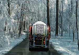
Louisville Metro, Kentucky, is a partner in the Louisville/Jefferson County Information Consortium (LOJIC) and is using its GIS and ArcIMS to coordinate and interactively track, report, and map brine pretreatment, salting, and snow removal activities of its road crews during snowstorms. When the Metro area is under a snow alert, the ongoing location and status of road treatment and clearing work are publicly accessible from its interactive ArcIMS viewer—Snow Routes Map—which is available from the Louisville Metro Web site at www.louisvilleky.gov and from the LOJIC Web site at www.lojic.org. Snow removal can be expedited using salt and a saltwater solution called brine, which lowers the freezing temperature of water, thereby reducing the amount of snow and ice to be scraped off the roads and reducing road hazards. With more than 3,000 miles of roadway in Louisville Metro, priority is given to clearing main thoroughfares, school bus and local transit routes, hospital service routes, roadways to major businesses and industries, and high-volume secondary roads having potentially hazardous grades or curves. During snow emergencies, more than 1,000 roadway miles, divided into 117 designated snow routes, are salted and plowed by Metro road crews. Another 1,000 roadway miles, including interstate highways, are cleared by a combination of state government, suburban cities, and private contractors, and the remaining 1,000 miles of low-volume local streets are not cleared. To cover its designated snow routes, Metro relies on a combined force of 225 employees and 129 vehicles from Public Works, Solid Waste Management, Metro Parks, and Metro Sewer District. For roadway treatment, Metro keeps on hand 40,000 tons of salt, half of which is stored at various facilities across the community and half underground for emergency reserves. This year, Metro government also purchased a 5,000-gallon/hour brine maker and six new brine distributors for a total of 10 units in its snow fleet.
Throughout a snow emergency, salt truck and snowplow operators maintain radio communications with Metro Public Works dispatchers to report operator location and completed road treatments. Status reports are then relayed to the snow command center and are tracked and updated using a custom Web-based editor. The editor application provides a user interface to back-end Oracle tables through a Java database connection. Status tables are updated for snow route number, supervisor, driver, truck number, completed activity, and start/end times for each treatment pass. The editor application also includes a quick reporting utility to produce summaries of all snow routes and corresponding counts for each roadway treatment activity for the duration of the snow event. The snow route activity table is related to the snow route feature class, a subset of the local street centerline geodatabase, and is used to map and symbolize the current status of pretreatment, salting, and snowplowing. Changes in the status table are immediately reflected in the ArcIMS Snow Routes Map. At the end of any snow event, treatment history tables are automatically generated and used for reporting to state government. Snow Routes Map users can navigate to an address or street intersection and pan/zoom in the map to see labeled streets symbolized to reflect the latest reported status of roadway pretreatment, salting, and plowing activities. The interactive map also displays schools and colleges, hospitals, parcel boundaries, airports, parks, and other local landmarks. Using the snow route Identify tool, users can click on any street segment and see a chronological summary of all activities completed for that street. Snow Routes Map also includes a standard layout print tool and a comment tab to allow users to provide feedback on map performance and problems and to offer suggestions. The Switch Map drop-down menu allows users to toggle to all other LOJIC ArcIMS interactive maps and maintain a consistent view extent. Louisville Metro conducts annual audits of local snow routes and treatment activities using the LOJIC GIS as its common tool for analyzing and adjusting routes to meet the greatest local needs. Metro's use of GIS to coordinate, track, and report snow treatment and removal has improved responsiveness and accountability. The ArcIMS Snow Routes Map, widely publicized by Metro government and local media, provides a quick and easy means for residents to check on the status of snow removal and road conditions at any time of day or night. About the AuthorsCurt Bynum, GISP, is GIS coordinator, and Brian Meyers, GISP, is senior applications analyst, for LOJIC. The LOJIC partnership consists of Louisville Metro government, Jefferson County Property Valuation Administrator, Louisville Water Company, and Metro Sewer District. More InformationFor more information, contact Eric Weidner, Metro Public Works (e-mail: eric.weidner@louisvilleky.gov, tel.: 502-574-3871), or Brian Meyers, GISP, Louisville/Jefferson County Information Consortium (e-mail: meyers@lojic.org, tel.: 502-540-6324). |