Fall 2008
Fall 2008 |
|||||||
|
|
|||||||
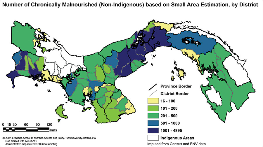
Analyzing Distribution of Malnourished Children in Panama, Ecuador, and the Dominican Republic
Mapping Hunger with GIS |
|||
Highlights
Reducing poverty and hunger is the first Millennium Development Goal of the United Nations. Hunger, defined in terms of nutritional status, is most commonly measured among children and contributes directly to morbidity, mortality, and poor cognitive development. A first step toward realizing the goal of reducing malnutrition in children is to identify places where the problem is the most severe.
The Gerald J. and Dorothy R. Friedman School of Nutrition Science and Policy at Tufts University in Boston, Massachusetts, is a leader in food policy research and the development of innovative solutions to reduce malnutrition worldwide. In conjunction with the United Nations World Food Programme and the governments of Panama, Ecuador, and the Dominican Republic, the Tufts Malnutrition Mapping Team (TMMT) has helped pioneer a method that estimates the prevalence and number of malnourished children for small geographic areas. This helps governments use scarce resources effectively by focusing on areas where the problem is more severe and by revealing underlying geographic factors that cause malnutrition in different settings (e.g., rural versus urban, mountains versus coast). ArcGIS software was selected for this mapping exercise due to the functionality of its ArcGIS Spatial Analyst extension, which enabled TMMT to calculate the numerous geographic variables included in the analysis. ArcGIS provided a straightforward platform to map the results and thus provided a powerful tool for visualization of the nature and distribution of the nutrition problem in each country. The task of locating malnourished children is more complicated than it may first appear. Consider the fact that children's nutritional status is indicated by their height, weight, and age and that collecting this information for every single child in a country would be nearly impossible due to the cost and time needed to measure and weigh. But, typically national surveys take a sample of the whole population, which is often representative for provinces but not for smaller geographic units. Malnutrition maps for Panama, Ecuador, and the Dominican Republic were developed in ArcGIS using Small Area Estimation, a statistical procedure that combines data from a sample national population survey with a national census. GfK GeoMarketing, an Esri Geoinformatik GmbH Business Partner in Waghausel, Germany, supplied TMMT with geographic data that details administrative boundaries and major cities. TMMT used this information to calculate the distance from small communities to urban centers, a proxy measure of market access. As GfK GeoMarketing has an extensive library of global geographic data, it was a logical partner for TMMT to approach. In addition to producing malnutrition estimates for Panama, Ecuador, and the Dominican Republic, TMMT has also created a malnutrition mapping manual. The goal of the manual, which is also the ultimate goal of the project, is to increase the technical capacity of developing countries and provide them with the tools and expertise to conduct their own malnutrition mapping exercises. More InformationFor more information about the work of Tufts' Malnutrition Mapping team, contact James P. Wirth (e-mail: jpwirth@gmail.com) or Beatrice Rogers (e-mail: beatrice.rogers@tufts.edu). The findings for all three country analyses are published in a report in the Working Papers in Food Policy and Applied Nutrition series on the Friedman School of Nutrition Science and Policy Web site (nutrition.tufts.edu), or contact Cornelia Lichtner, GfK GeoMarketing (tel.: 49-7251-9295-270, e-mail: c.lichtner@gfk-geomarketing.com; Web: www.gfk-geomarketing.com). |