Fall 2008
Fall 2008 |
|||||||
|
|
|||||||
Philadelphia Thanks GIS for the Memories |
|||||||||||
Highlights
Historic events, such as the drafting of the U.S. Constitution, and attractions, such as the Liberty Bell, have put Philadelphia, Pennsylvania, on the map, but the geographic fabric of the city is more than a maze of national historic sites. Philadelphia, like many metropolises, is a spider web of districts, neighborhoods, streets, buildings, and houses. Fortunately, since the invention of the photograph, Philadelphians have thoroughly recorded the evolution of their city. Images documenting Philadelphia's history and geographic changes can now be seen via a GIS-enabled Web site (PhillyHistory.org) that combines the city's impressive and ever-changing urban landscape with images of its colorful past, revealing what life was like years ago.
Until recently, an estimated two million photos, dating back to the mid-nineteenth century, have been stored in thousands of boxes at the Philadelphia City Archives, managed by the City of Philadelphia's Department of Records (DoR). Many were also stored in old envelopes and were deteriorating quickly from acid in the paper. Except for a handful of images published in books, the photographs were not easily accessible to the public. Moreover, while most of them had been processed and cataloged in a database by year and by the city department that had taken them (e.g., Streets Department, Water Department, Department of City Transit), they were not easily searchable. Joan Decker, commissioner of the Department of Records, knew something had to be done in order to properly catalog and preserve the city's visual history. "The database that we had for indexing photos was old and outdated," explains Decker. "It was a rarely updated desktop database that only included a tiny fraction of the collection, and there were no actual photographs attached to the index. Also, it was strictly internal. I wanted to make sure that whatever the solution, it would provide more information to the public." The DoR entertained ideas from various sources, but as it turns out, the solution to the archiving and preservation dilemma was right around the corner—literally. Philadelphia-based Avencia, Inc., an Esri Business Partner and geospatial analysis firm already involved in numerous city neighborhood revitalization projects, had a picture-perfect plan.
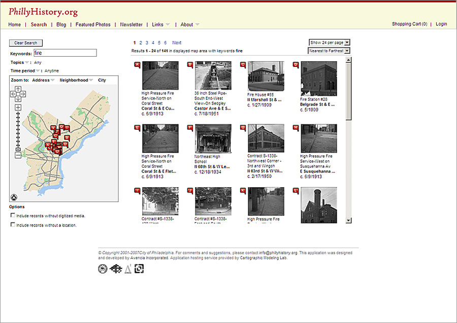
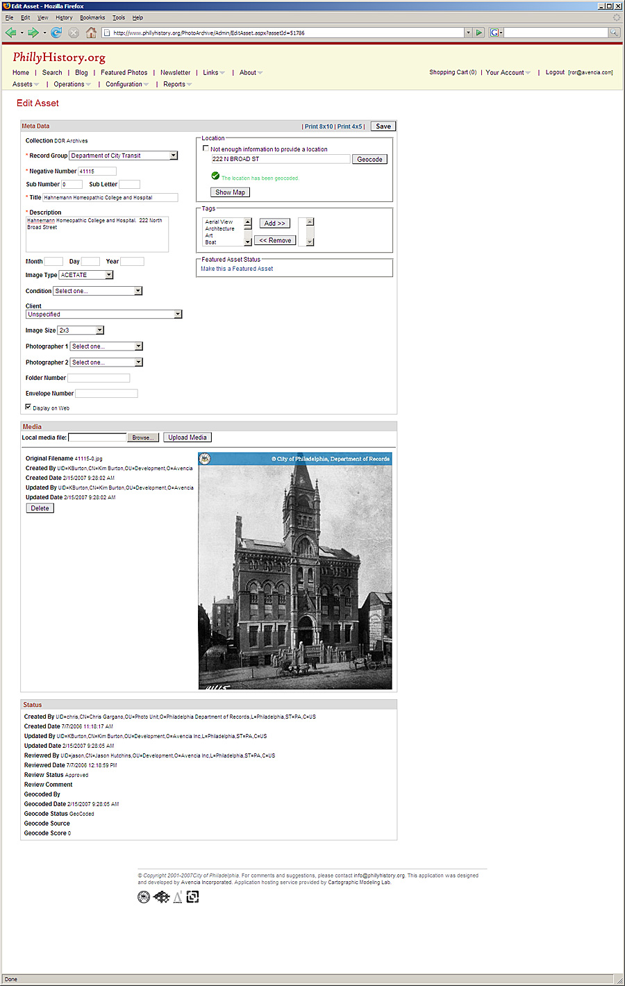
"Avencia had really wonderful ideas for building an easy-to-manage system and for making it widely available to the public with different interactive features," says Decker regarding the DoR's decision to contract with Avencia on the project. "They have a very strong track record here at the city, and we really liked their ideas about a blog and a featured photo of the week. PhillyHistory.org has really exceeded our expectations." Using ArcGIS Server, Avencia worked with the city to create a Web server-based digital asset management system (later marketed under the name Sajara) that enables employees of the DoR and public history interns working at the archives to upload images and assign map coordinates to each via a flexible geocoding function. The system is also used to manage, update, and record metadata pertaining to each image, such as the condition, origin, and other characteristics of the original image. The result is PhillyHistory.org, a geographically searchable Web site that enables the public to search for photos by address, intersection, location, keyword, category, or historic date with search results displaying thumbnail images, descriptive information, and map locations. From the start, public feedback on PhillyHistory.org has been overwhelmingly positive. "I looked up the address of the house where I was born, and believe it or not, there's a photo with my sister in it, and I believe my grandmother is partially hidden," says one PhillyHistory.org user. "What a thrill. I can't wait to show it to my sister."
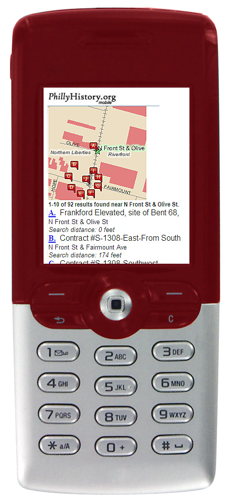
Since June 2005, when PhillyHistory.org went live, the interns and employees of the DoR have scanned and uploaded more than 84,000 images at a rate of approximately 2,000 per month. As each photo is processed, it is placed in an acid-free envelope and reshelved, contributing to conservation of originals. The Web site attracts thousands of unique visitors each month, and an e-commerce module supports funding of the project through the sale of prints and digital photos. Other features include the PhillyHistory blog and a quarterly newsletter, both written by historians, interns working at the archives, and the Avencia staff. The site has been so successful that it has garnered the attention of the media and the public alike, and most importantly, other organizations. In this day and age, digitizing assets and making them available on the Internet has become of utmost importance for organizations that, like the DoR, have assets that are deteriorating. As a result, PhillyHistory.org now also hosts 5,000 historic maps from the Free Library of Philadelphia, and 1,300 photos from the Philadelphia Water Department. The different collections are easily distinguishable thanks to their own colored watermark. They can be searched together or separately thanks to filters, while authorized users from each organization have access to the system's Archive Manager, enabling them to update, manage, and add metadata and retrieve reports proper to their own collection. Avencia's software engineers deploy a new version of the software every month. PhillyHistory.org enables users to quickly find updated records, as well as save and share favorites, bookmark searches, and subscribe to an RSS feed for notifications each time a photo in the vicinity of their bookmarked searches has been added. They can also now see the returns of their queries or the whole collection in Google Maps or Google Earth. A popular Philadelphia Historic Street Name Index component of the site matches former street names to their current names, making it easier for historians and researchers to find current addresses of historic buildings or residences. Additionally, Decker wanted a mobile version of PhillyHistory.org. "I thought it would be wonderful if we could take advantage of the Philly Wi-Fi initiative and the increasing number of Internet-enabled phones and handheld computers to create a mobile component to the site," says Decker. "It would be a great tool through which our city's tourism industry and educators could conduct walking tours."
The team answered with PhillyHistory Mobile, accessible from Web-enabled cell phones, handheld computers, and other mobile devices. Like PhillyHistory.org, the mobile extension is made possible by a Sajara-based GIS application built with ArcGIS Server, ArcIMS, and the Microsoft ASP.NET framework. The mobile module features a simple user interface and the same search functions as the Web site. With PhillyHistory Mobile, people can see what their exact physical location and its surroundings used to look like, and it has helped increase traffic to PhillyHistory.org's e-commerce store. The press' interest in both forms of PhillyHistory media has also contributed to their popularity. "This is the best use of taxpayer money I've heard of in a long time," comments Duane Swierczynski, chief editor of Philadelphia City Paper. Says Decker, "Every time we receive coverage in one of the papers or publications, we can see a spike in Web site traffic, and it continues to go up. The feedback has been tremendous. It's a wonderful way to bring archival imagery to the public. It brings the city alive, and it gets people very interested in the city's history." PhillyHistory.org is so well-received by the City of Brotherly Love that it was awarded a Best of Philly 2007 award for Best Local Web site by Philadelphia Magazine. It also received a 2007 Exemplary Systems in Government Distinguished System award from the Urban and Regional Information Systems Association (URISA) and the 2008 Henry Magaziner Award from the AIA Philadelphia. The Art Institute of Philadelphia is planning another exhibit to open in December 2008—after the success of their 2007 Philadelphia Stories: The Building of a Great American City—that will showcase an exhibit of more than 80 images borrowed from what was once an archiving nightmare of sparsely indexed photographs stored away in boxes. Thanks to GIS, that problem is history. More InformationTo view images of Philadelphia's past, visit www.phillyhistory.org. From a mobile device or handheld computer, go to mobile.phillyhistory.org. For more information about Philadelphia's use of the Web server-based digital asset management system Sajara, contact Rachel Cheetham-Richard, vice president, Avencia (e-mail: rcr@avencia.com) or visit www.avencia.com. |
|||||||||||