Fall 2008
Fall 2008 |
|||||||
|
|
|||||||
Nebraska Emergency Management Agency Expands Mobile GIS Capabilities
Small Agency Does Wonders with a Small Budget |
|||||
Highlights
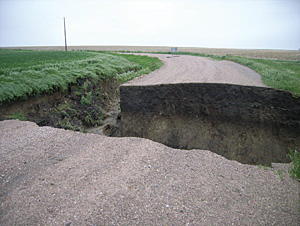
For disaster response teams in the field, GIS is a technological lifeline. It has been part of the toolkit at the Nebraska Emergency Management Agency (NEMA) for more than five years.
One of three units in the Nebraska State Military Department, NEMA operates from a Cold War-era bunker built in the 1960s. The organization is directed by Brigadier General Timothy J. Kadavy, who also commands the Army National Guard and the Air National Guard. Most of the year at NEMA, primary emphasis is on preparedness. The agency acts as a support system for local communities as they respond to tornadoes, floods, blizzards, and other threats to public safety—including a terrorist strike. With just 35 full-time and part-time employees, NEMA is small. Multiple responsibilities and a tight budget between disasters mean that the agency looks for ways to leverage resources. "Now," says Chad Boshart, GIS specialist at NEMA, "a new software acquisition is enhancing the way NEMA uses GIS in the field." The Field Adapted Survey Toolkit (FAST) software from GeoAge (an Esri Business Partner located in Jacksonville, Florida) is built on an Esri platform and is currently in trial mode as NEMA trains to deal with future emergencies. "We're exploring the ways this software can help us work better in the field," adds Boshart. "What we know already is that our teams can create survey forms that are specific to the task at hand and then attach GIS coordinates and digital photos." These capabilities, he explains, will be advantageous for NEMA teams charged with identifying and quantifying key information in an emergency: hardest-hit areas after a tornado, available shelter beds by location, blocked evacuation route points, navigable detour routes for emergency responders, and more. "Using the new survey capabilities," continues Boshart, "we've added more location information, description fields, the level of destruction, if cleanup has been started, etc. We can integrate that kind of information with GIS coordinates, and anybody on the team can learn to do it in a day or less."
Data collected by FAST can be viewed through ArcPad, which serves as a reference to verify locations. NEMA deploys the software via Hewlett-Packard iPAQ PDAs with cameras and Bluetooth GPS units, connecting to the Internet through the Alltel cellular network. Ease of use is a feature of the new technology: Anyone familiar with Microsoft Windows can be up and running quickly. "This," says Boshart, "is important for an agency like NEMA, which is sometimes called on to deploy a team with minimal notice. It's a way to have the flexibility to collect any data you need right away." He notes that data can be exported in shapefile format, then added into GIS. "I can use it with just about every group we have at NEMA. When you have to respond quickly, you almost instantly have situational awareness and know where to send people, help, and resources. It helps you prioritize. And that helps you save money; save time; and, possibly, save lives." With field teams effectively using ArcGIS Desktop functionality and components, GIS experts at NEMA headquarters can map data using ArcGIS Engine. "Before, people would just write down information in numerous different ways," remarks Boshart. "Some wrote down coordinates; some just described what they saw. The data was difficult to use and prone to human error, and that became especially important when time was short. The difference is that we can now be on the same page, using all the advantages of technology." Boshart reports that the agency has trained workers who had no prior GIS knowledge one day before they were sent to the field. All of them successfully collected and reported data from the field, identifying structures and critical infrastructure to share with neighboring states in a Web-based data display. For Boshart, a GIS expert himself, the value is obvious: "This allows other people in the agency to use GIS technology without having to be an expert in the software. People don't have a lot of time to learn new things. The fact that it's so easy makes a big difference. For me, it's the fact that I can feel confident in the ability of our field staff to do a great job." More InformationFor more information, contact Sue Krogman, information technology administrator, NEMA (tel.: 402-471-7429, e-mail: sue.krogman@nebraska.gov); Chad Boshart, GIS specialist, NEMA (tel.: 402-471-7180, e-mail: chad.boshart@nebraska.gov); or Jeff Arnold, GeoAge (tel.: 866-565-9855, e-mail: jeff.arnold@geoage.com). |