Fall 2009
Fall 2009 |
|||||||
|
|
|||||||
GIS, Design, and Evolving Technology |
|
|
By Jack Dangermond
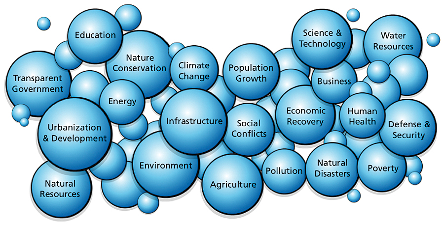
GIS Users Are Making Geographic Information Mission Critical to SocietyThe purpose of our annual User Conference is to focus on you, the GIS user: to focus on your work, provide you with knowledge and assistance, and help you build relationships with your peers. You are doing very important work in many areas, such as forestry, land-use planning, conservation, national security, and utilities. But at the same time, you are also building the information infrastructure on which will be built the next chapter in the history of the world. You are creating a powerful new kind of information that will lay down the fabric for creating a more sustainable future. The work you do is making a difference. And whether or not you realize it, you are working on virtually all the world's challenges—from economic recovery, government transparency, urbanization and development, and open-space planning to environmental assessment, conservation of nature, climate science, and designing our future.
GIS: Designing Our FutureThis year's conference emphasized the interesting relationship between design and GIS with emphasis on the concept of "GeoDesign." Today, GIS professionals work with geographic information to manage many aspects of our world. Design is a discipline and process where people deliberately create. Design is about purpose and intentions; it's about seeing in our mind's eye what could be, then creating it. GIS can provide a platform for integrating geographic science with design. I like to refer to this as the field of GeoDesign. One of the big challenges facing our society today is the rapid change that humans are making to our global environment. While there are certainly many amazing advances taking place in areas such as technology, health care, and basic scientific understanding, we are also severely affecting our natural environment—the foundational infrastructure for sustainable life.
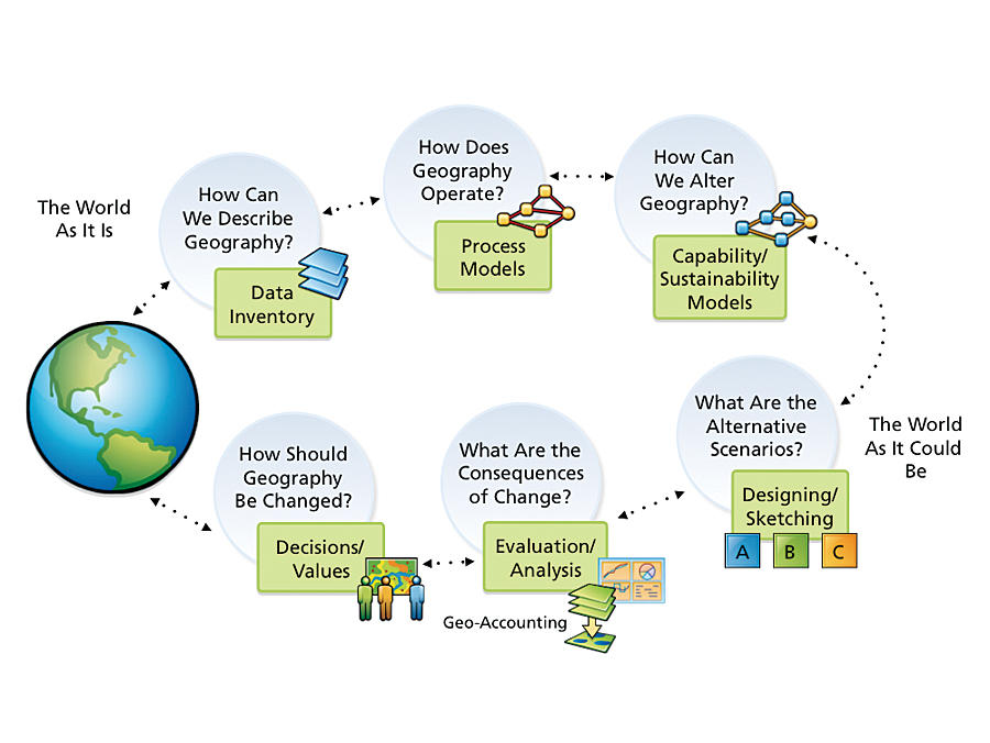
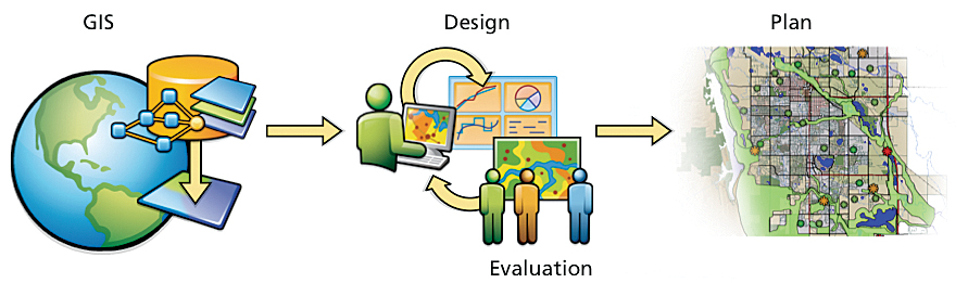
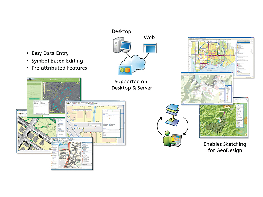
These changes are largely the result of uncoordinated, unguided human activities. Our landscapes are becoming more fragmented, depleted, polluted, and eroded; in some cases, they're actually disappearing, becoming extinct. This is a tragedy for our future, and it's happening largely because we are not consciously designing our future, and we are not evaluating and accounting for the long-term impacts of our actions on our communities, our environment, our society, our climate—our world. My message is simple. We need to move from a future that simply happens to one that is purposefully designed with full understanding of the consequences. This will take many participants and more conscious and collective action—action guided by our best vision, science, and intentions. We need to design our future while fully accounting for and being responsible for the consequences of what we do. I believe GIS and GIS professionals hold the promise for accomplishing all this. GeoDesign is a systematic methodology for geographic planning and decision making. GeoDesign starts by incorporating all the geographic knowledge that users collectively build and maintain—layers of information, measurements, and analytic models—and plugging it into a new interactive process where one can design alternatives and get geography-based feedback on the consequences of these designs right away. "What if we do this here?" "What is the impact of that alternative versus this alternative?" This iterative design/evaluation process is fundamentally how the human brain works; we try something, evaluate the results, and move on. Geographic SketchingGeographic sketching is the central GIS tool for supporting GeoDesign. This new capability allows users to quickly sketch their design ideas on top of suitability maps and get immediate feedback on the performance or impact of the design being proposed. The GIS framework provides instantaneous feedback in the form of maps, charts, and statistics and enables rapid testing of multiple design services. Dr. Carl Steinitz, professor of landscape architecture at Harvard University, first described how the GeoDesign process worked by posing it in the context of six geographic, or landscape, questions.
The first question is, How can we describe geography? This is done in a GIS by abstracting geography into a series of inventory data layers. The second question is, How does this geography actually operate? Here, GIS is used to combine data with spatial analysis modeling to describe geographic processes. Examples include soil erosion, land-use and vegetation change, hydrology, and traffic flows. Process models predict or describe how various spatial phenomena change with respect to time. The third question is, How can we alter geography considering all the factors? GIS uses suitability and capability modeling to answer this question. Various map factors are overlaid and weighted relative to their merits for a particular use. These first three questions describe the world as it is; the following questions describe the world as it could be. First, What are the alternative scenarios for designing the future? This involves sketching out the options. Then, How can we quickly evaluate the consequences of those changes? Here, GIS can be used to evaluate the impacts of each alternative. Last, How should geography be changed? This integrates considerations such as policies and values into the decision-making process. The concept of GeoDesign integrates all six of these steps, providing us with a rapid, adaptive process for creating a more sustainable future. GeoDesign Will Extend into Every FieldGeoDesign is an evolutionary step in the GIS field. While very exciting for land-use and environmental planning, GeoDesign has broad implications for virtually all professions. This methodology will be applied in many fields—by retailers who want to understand the consequences of opening or closing stores; by engineers who want to locate a road in the right location; and by utilities, farmers, foresters, law enforcement, energy companies, and military organizations, to name just a few. This approach will move GIS beyond simply describing the world as it is toward the idea of creating the future, integrating geographic thinking into all the work we do.
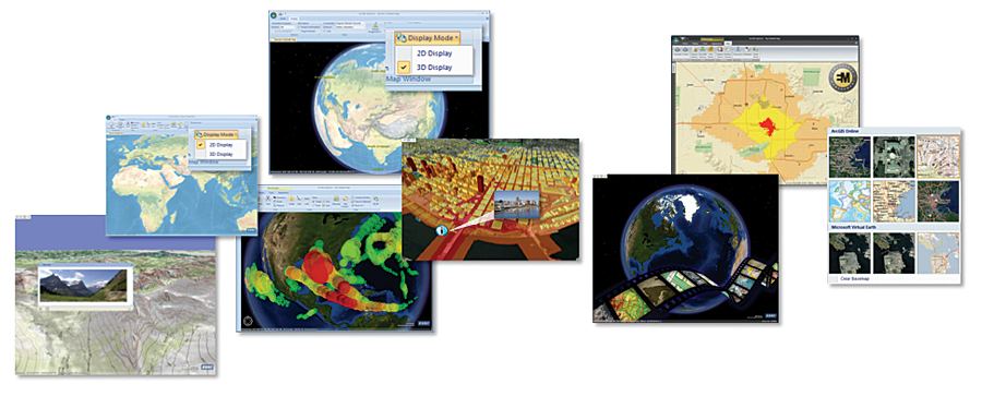
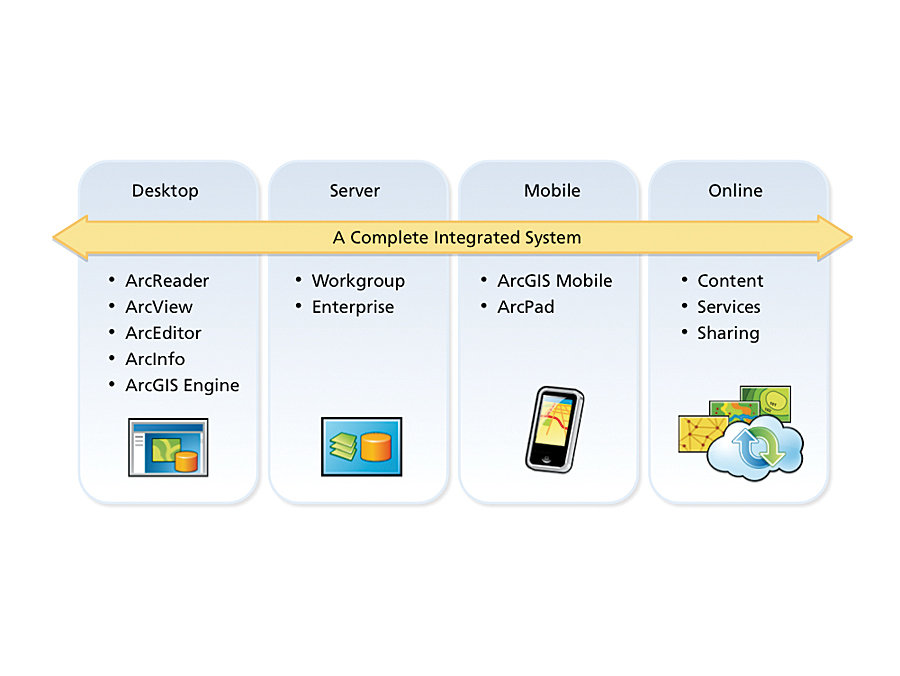
GIS professionals will chart the future using GeoDesign maps. These maps will become a new language for us to communicate and evaluate the future, showing the world as it could be, encapsulating geographic knowledge with purposeful design. This process is about bringing information and science into the way that we make decisions. Our new president is fond of saying he wants to put science in its rightful place. This is where I think its rightful place is—supporting the creation of the future with new kinds of maps that bring it all together. The Next StepMaps and GIS are changing. They're becoming richer, smarter, and more dynamic. They are also becoming more pervasive and being presented using new styles, new patterns, and new techniques. The Web and Web 2.0-style mashups are leading to a new breed of maps and geographic analysis. People are integrating traditional GIS data (services) with new media types, such as social networks and real-time data. This movement will lead to geographic knowledge becoming even more widespread in society. This Web environment offers many opportunities for GIS professionals to be creative with new forms of cartography and spreading geographic knowledge everywhere. Platform EvolutionToday, GIS is being implemented in many different patterns. The desktop pattern is perhaps the most pervasive. Server and enterprise implementations are especially useful in the area of managing organizations, and we see a plethora of new client types, such as rich Internet clients and mobile clients. All these patterns are flourishing and growing, influenced by advances in the technology, faster machines, increased bandwidth, more storage, and the emerging cloud-computing resources that can be leveraged and integrated into applications. Today, all these patterns are also integrated with the Web. The Web is linking us and tying our geographic knowledge creation and services into a larger network or infrastructure. GIS servers are playing an increasing role in this evolution. They're powering the enterprise and thousands of types of geospatial Web applications—fast maps, the publishing of globes on the Web, and the connecting of mobile workers. They are also supporting mashups and enterprise integration and integrating GIS into other parts of the IT infrastructure. The server is emerging as the foundation for creating spatial data infrastructure with multiple sources of data, services, and applications. The server is also the GIS platform for cloud computing. The Web as a GIS Platform—Emerging RapidlyIn Esri's lifetime, we've witnessed the rise of many platforms, including mainframes, minicomputers, workstations, PCs, and client-server computing—lots of waves of change—and every time, we have morphed our technology to take advantage of the latest platform. We're now at the dawn of a new era: the era of Web GIS. The Web is a strong platform for GIS. Web GIS is about serving, integrating, and distributing geographic knowledge—your work—and making it available everywhere. As GIS professionals, you are building the content that drives the GeoWeb. You're building the data—authoritative data, not just casual data. You're building high-quality maps, visualizations, and spatial analysis models. You have the geographic knowledge, and you have the skills needed to describe it and share it and build rich applications. In this environment, you are beginning to leverage all that content and knowledge for many new kinds of users. Citizens, knowledge workers, field-workers, industry experts, executives—actually, everyone—can now gain access to your geographic knowledge and leverage it in their own domain.
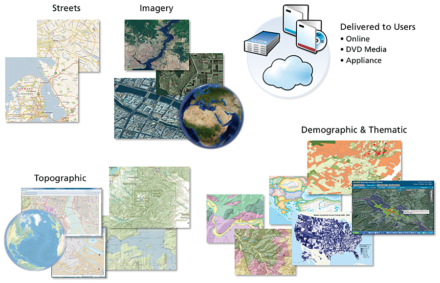
The technologies fueling this growth are the powerful GIS server technology together with easy-to-use client technology. The clients include the new rich Internet applications, geobrowsers (i.e., ArcGIS Explorer), and mobile applications. These, coupled with the growing online content and Web sharing capabilities, are fueling a very rapid deployment. This is a very exciting time for GIS. From my perspective, it's the most exciting time so far. Web GIS is creating an environment where the applications and the good that GIS can do are about to explode—explode in terms of leveraging our common reservoir of digital geographic knowledge. Esri GIS SoftwareThe main focus of Esri's work is designing software for our users (maps, data, models, visualization). ArcGIS is a complete and integrated system for authoring and serving geographic knowledge. ArcGIS works on mobile devices, on the desktop, on the Web, in enterprise environments, and across the cloud. Presented here is an overview of recently released and soon-to-be-released additions and enhancements to the ArcGIS platform. ArcGIS 9.3.1 At 9.3.1, we made a substantial improvement to the ArcGIS platform, focusing on quality, performance, and scalability, and particularly on fast dynamic map display on the Web or in enterprise environments. We also enriched ArcGIS with a number of rich clients. We introduced some new ways to easily share data and expand online content for people to use, and we simplified some licensing. This is a valuable platform for this next generation. Layer Packages Layer packages are a new way to package your data, map the symbology associated with that data, and share it. Many of you do this now, but layer packages make the process much easier. You can create a layer package and share it on a CD/DVD, put it into a shared file system, e-mail it as an attachment, or upload it to ArcGIS Online.
ArcGIS Online ArcGIS Online provides a rich library of maps and imagery for the world. This year, Esri has extended ArcGIS Online with a powerful sharing capability that allows users to find and share maps, layers, and tools on the Web. This capability is in many ways like Flickr (the photo-sharing Web site). The ArcGIS Online sharing site has been designed to allow users to find, upload, and share content either with defined groups (such as their own enterprises) or publicly. The managers of these groups can choose with whom to share their maps and data. They can restrict or allow access at the individual or group level or choose to share their work with anyone. Next-Generation Geobrowser The recently released version of ArcGIS Explorer represents the new standard in geobrowser technology. It has incorporated many new features and capabilities, including a more intuitive user experience, integrated 2D and 3D map display, enhanced data support, integration with ArcGIS Online, easy customization, and a software developer kit. ArcGIS Explorer is a free and exciting desktop client that can be used to view and mash up virtually any geospatial service, as well as integrate local and enterprise GIS datasets. Application Templates One of the things we've focused a lot of energy on is making it easier for you to get your work done. We think about this in terms of common applications that all our users employ. We've begun providing a set of desktop and server templates that help you implement ArcGIS. Templates will help you configure and use ArcGIS; they include data models, maps, styles (MXPs), and tools. When you find a template you're interested in, you can watch a video to learn how to use it, view it live on the resource center, or download the contents of the template to configure it in your organization.
You may also want to review the resource center for information on technical topics. When you download a template from the resource center, you'll get a sample geodatabase and map layers. You'll also receive one or more map documents to help you visualize the layers in that geodatabase. We also provide documentation and a getting-started guide to help you configure the template in your organization. Templates are not meant to be the whole solution, but they are meant to get you started quickly with best practices. Business Solutions Esri's business solutions include a number of different products. ArcLogistics is a fleet management tool to create optimized routes and efficient schedules. The Business Analyst product suite is used in site evaluation and selection, as well as exploring customer opportunities related to specific locations. A new mapping-focused solution called MapIt is a product for simple database mapping. It was jointly developed by Esri and Microsoft. MapIt allows you to create maps showing information from Microsoft SQL Server and Excel. It includes access to basemaps, geocoding, and routing services from ArcGIS Online and Bing Maps, as well as Esri Business Analyst Online API drive-time and ring analysis and demographic data services. MapIt integrates with applications such as SharePoint and has a Silverlight viewer. We see MapIt as a way to propagate more mapping and map literacy in the IT environment. ArcGIS Desktop 9.4In the second quarter of 2010, Esri will release ArcGIS 9.4. This product will reflect many user- requested enhancements. We're doing an overhaul of the user experience of desktop. We're also doing a lot of work in the areas of editing, geoprocessing, spatial analysis, and publishing and sharing maps to the server. A major focus is reducing the number of clicks and the number of concepts you need to understand to get your work done.
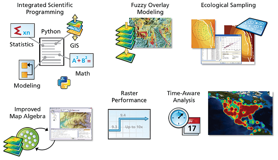
ArcGIS is going to become a lot easier and more productive to use at 9.4. New tools and features are being added in this release, including fast map display; time visualization; integrated search; improved organization of default menus; the integration of the catalog inside ArcMap; a dynamic table of contents; better maps, reports, and tables; and direct access from the desktop to spatial type data in RDBMSs, enabling advanced SQL functionality. ArcGIS 9.4 will also support license checkout, so you can check out a license for a while, put it back in, and share it with somebody else. ArcGIS Innovation There are a number of themes in ArcGIS 9.4. Usability and productivity are certainly two of them, but they also include data management, making GIS more mobile, spatial analysis supporting science, cartography, best practices, sharing, and much more. The focus of this release is to make you more productive and improve some underlying things like quality and performance. Improved Editing At 9.4, editing gets a whole lot easier, both for traditional GIS users (compilation and editing) and in the design-based (GeoDesign) sketching workflow. ArcGIS 9.4 uses a simple graphical approach to creating features. To create features, you just pick a symbol from the list and start drawing on the map. It's really that simple. ArcGIS 9.4 also uses a simple snapping environment that is always available, is fast and responsive, and provides graphic feedback so that you always know exactly what you're snapping to. We're also working on improving selection and how the editor works with layers. Advanced Mapping ArcGIS 9.4 fundamentally advances map visualization and cartography. It introduces new methods for creating maps at different scales by simplifying features. The ability to automate common workflows is one of the key underlying features of 9.4. Map automation allows updating symbology and changing data sources for maps and layers using scripting (Python). The creation of multipage map books with dynamic elements can now be automated with Python. Spatial Analysis Spatial analysis is the heart of GIS, and a huge step forward is happening at ArcGIS 9.4. We are fully integrating Python inside ArcGIS. Python is rapidly becoming the accepted standard for scientific programming, and its integration will bring a lot of advances in geographic science. We are also adding fuzzy overlay modeling, improved math/algebra integration, and radically improved raster performance for analytic operations. We're integrating time through the whole stack, at the user interface and into analytics, and we're introducing an ecological sampling tool that brings a lot of geostatistics into play.
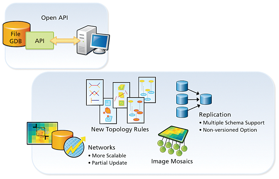
Network Optimization and Analysis Another significant spatial analysis enhancement is network modeling. At 9.4, we are adding location-allocation modeling, which helps locate optimal places for things like fire stations, retail stores, and banks. We're also adding gravity modeling, the ability to do dynamic barrier setting like street closures for network routing, and time-dependent routes. Being able to embed that in the geodatabase so that we can have more time-related routing is another step in advancing our methods. A Complete 3D GIS We've been working for years on making ArcGIS fully 3D, and 9.4 makes ArcGIS a complete 3D GIS, creating a more powerful visualization environment for things like virtual cities. It supports a complete 3D vector data model, opens up a lot of the analytic operators, supports 3D and terrain editing, and allows the integration of real-time video. There's also a huge increase in performance in visual display. ArcGIS Server 9.4At ArcGIS Server 9.4, we're introducing new Web clients, a new editing service, enhanced mapping, optimized image service, time integration, SharePoint integration, and much more. We're also adding the ability to zip, clip, and ship your data cells. We will provide an open API to the file geodatabase. The 9.4 release will also strengthen data integrity and a lot of the workflows associated with geodata management by adding new topological rules and better support for very large networks; enabling the partial update of very large networks without having to rebuild the entire logical network; and providing a new geodatabase image type called Mosaics that allows users to access image data in its native format, dynamically build on-the-fly mosaics, and offer fast performance.
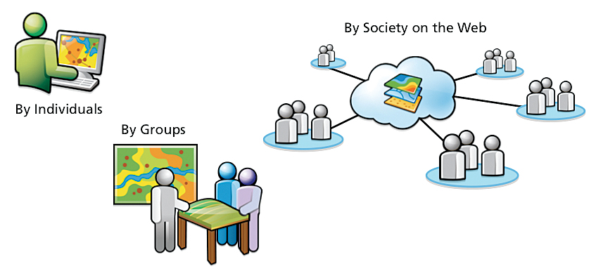
Collaborative Data Collection Web editing in 9.4 will support the notion of collaborative data collection. It allows many people to share and build a common understanding, designing together for a particular geography without being in the same room at the same time. A Strong Platform for Imagery In the last two years, Esri has taken a major strategic direction to improve and integrate imagery directly into the core ArcGIS platform. ArcGIS is a very strong platform for imagery today, and 9.4 will dramatically improve display speed, integrate on-the-fly image analysis on the desktop, and support massive scalability through the introduction of Mosaics. (See "Imagery: A Core Component of GIS" by Lawrie Jordan.) Mobile GISBlackberries, iPhones, and other mobile devices are exploding in popularity, and ArcGIS is poised to support this explosion. Mobility isn't just about one niche—mobile GIS will connect everybody. This includes GIS professionals; field-workers, who might just do some GIS data collection and analysis; knowledge workers, who might embed a very simple task associated with geography or geographic information; and finally even executives, who might want to get a real-time view of exactly what's going on. With the mobile capabilities of ArcGIS 9.4, anyone can access your services. Supporting Our UsersEsri is more than simply software—it's an organization that's designed to support you, our users. Our other goals also continue to be the same: advancing GIS and geographic science, spatially integrated thinking, and supporting our employees in their growth and their own professional development. This year, Esri is 40 years old. It's important to know that we are unchanged in our fundamental purpose, which is serving you. These are difficult times for many organizations, but I want to assure you that Esri is secure, financially sound, and growing as an organization, thanks to you and many of our other relationships. Professional Services Esri is dedicated to helping customers be successful, to realize the full potential of the software. Esri's Professional Services' mission is to support customers and business partners around the world in the effective use and application of Esri software products, as well as to use the lessons learned from projects to influence software development. Today, the division comprises some 600 domain specialists and GIS/IT professionals, located in more than a dozen cities in the United States and several overseas. The division's activities range from providing focused and advanced support under extended support programs to carrying out large database and system development projects. In many cases, projects involve the implementation of ArcGIS software in mission-critical enterprise environments. Esri teams with its more than 2,200 business partners to further expand its consulting capacity and capabilities to ensure that customers are fully supported. User Communities When we talk about designing powerful and effective GIS systems, this is largely about you—the GIS professional and your work. Esri is not the expert here; you are. Esri provides software tools, training, support, best practices, data, services, and other components to support you in building, maintaining, and growing your GIS systems. But we have always felt that one of our biggest, most important contributions to your success is building and supporting communities. How you design your systems, maps, databases, and the governance systems that make these things work—this is some of the most valuable geographic knowledge of all. Your investment can be summarized and shared with other GIS users as best practices, streamlining the development of their systems. There are many opportunities for you to learn from the best practices of other users—that is the basis of Esri's community building. Our international and regional user conferences, user group meetings, online sharing opportunities, publications, and more, have proved highly successful at connecting you to other users, and our commitment to these valuable forums remains steadfast. See also "Users Learn from Each Other at the 2009 Esri UC." |
 More than 12,000 GIS professionals met in San Diego, California, in July for the 29th Annual Esri International User Conference. Given current economic conditions, I appreciate the extra effort it took to make the trip to San Diego. I'd like to recap, for those who could not attend, some of the key points shared at the conference.