Fall 2009
Fall 2009 |
|||||||
|
|
|||||||
29th Annual Esri International User Conference Helps Professionals Chart the Future with Purposeful Design
Users Learn from Each Other at the 2009 Esri UC |
|
|
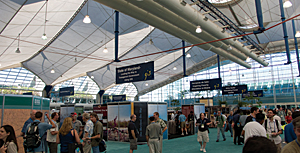
The 2009 Esri International User Conference (Esri UC), held July 13�17 at the San Diego Convention Center in California, marked Esri's 40th anniversary. GIS has evolved greatly over the last four decades, in part due to the global community that meets annually at the Esri UC. This year's 12,000 attendees from This year's conference started by showing hundreds of user slides demonstrating the value of GIS in a broad range of applications. Esri president Jack Dangermond urged attendees to keep focusing on and teaching each other, noting that the people there possessed the greatest store of knowledge about geography and how to interpret it and apply it. Plenary Focuses on Designing the FutureThe conference theme, "GIS—Designing Our Future," set the tone for the Plenary Session. "You are an extraordinary group," Dangermond told attendees, emphasizing that the reason for coming together was to celebrate their work as part of a large global network of GIS professionals. Dangermond discussed using GIS to design our future. "Geography is the science of our world," he said. "GIS can be used to integrate this science with the methods of design and planning to create a new profession—GeoDesign. An example of GeoDesign is land-use planning. We have the opportunity to change the direction of a future that is fragmented and depleted toward one that is purposefully designed and that considers all the factors. Future releases of GIS will give us the tools that support both geographic analysis and the creative design process. It will offer the science-based decision-making framework that communities need to chart in the future." Esri acknowledged the work of people and organizations that have impacted their communities. Cindi Salas accepted the Enterprise Application Award for CenterPoint Energy's extension of GIS into practically every workflow of the utility. The Making a Difference Award went to Dr. K. Kasturirangan, a member of the Indian National Planning Board, who's been influential in spreading remote sensing and GIS across India. Andrew Douglas-Bate accepted the Humanitarian Award for MapAction (see "MapAction Awarded for Applying GIS to Humanitarian Aid"). The President's Award was given to Maryland governor Martin O'Malley, who implemented GIS-based CityStat and StateStat programs for planning and managing Maryland's health, education, protection, and other government services. Dr. Henk Scholten, president of Geodan in the Netherlands, received the Lifetime Achievement Award, recognizing his dedication to GIS use in education and spatial data infrastructure. Showcasing the release of ArcGIS 9.3.1, Esri developers explained how they've focused on platform and making it easier to serve maps with GIS to a widening range of people. The technology offers more quality and scalability and supports rich Internet clients. ArcGIS Online was profiled featuring a new way to share data and maps via layer packages and many new free online content services. Previewing the coming ArcGIS 9.4 release, ArcGIS presenters showed how the software will become much easier to use and enhance performance, simplify workflows, increase productivity, improve editing, support Web collaboration, and advance cartography. (See also "Nine Innovations in ArcGIS 9.4.") FedEx gave a demonstration of how it uses ArcGIS to meet urgent shipping needs requiring special handling, from artwork to pharmaceuticals. The keynote speakers presented ways GIS is impacting environments and societies. Willie Smits, founder of the Borneo Orangutan Survival Foundation, Indonesia, talked about his use of GIS to study deforestation, habitat suitability, and land-cover change.
Tim Trainor, U.S. Census Bureau Geography Division chief, spoke about launching the world's largest deployment of mobile GIS. "Geography is core in everything we do," he said. (See "Bureau Chief Tim Trainor Says Geography Is Core of Census.") New to the conference, Lightning Talks took place after the plenary; these were five-minute demonstrations of inventive applications based on Esri Web and mobile technology. The Map Gallery and new Virtual Map Gallery housed hundreds of maps and presentations. The diverse collections—from housing foreclosures to ocean chlorophyll mapping—put attendees to the test when voting for their favorites in the different contest categories. Highlights and How-tosNumerous highlights peppered the conference with intriguing offerings each day. "Father of GIS" Dr. Roger Tomlinson moderated the 19th Annual Esri Senior Executive Seminar. Among the speakers was California's geographic information officer Michael Byrne, who called GIS the "new whiteboard" for decision makers. (See also "California Selects GIS as One of the Six Key Enterprise IT Strategies.) "During the plenary, the National Geographic Society and Esri's education team announced the GeoMentor program launch, rallying users in the audience to volunteer to assist educators and students with GIS projects. More than 150 Special Achievement in GIS Award winners were honored in a special ceremony, complete with a cheesecake bar and photo opportunity with Dangermond. With attendees in search of project guidance, answers to questions, and new goals, the week progressed with hundreds of user presentations, technical and industry sessions, and workshops. Special Interest Group and Regional User Group meetings organized by field, location, or topic facilitated networking. Product demonstrations and one-on-one conversations with Esri's Professional Services staff took place throughout the Esri Showcase. Additionally, more than 300 exhibitors were on hand in the Exhibit Pavilion to discuss their solutions and advancements. The Climate Change GIS Showcase sparked conversations about GIS and climate change issues. Launched last year, the Climate Change Program has continued to grow and offered a variety of discussions on alternative energy sources, forest carbon monitoring, and other conservation topics. Visually stunning Special Displays at the conference, provided by organizations such as the National Geographic Society and the State of Maryland, illustrated how GIS is an essential tool in today's world. At the Closing Session, Esri's senior directors answered questions from attendees. One of the questions to Dangermond was, "What's your passion these days? What still drives you?" Dangermond's answer: "Esri is a team of friends that drive and motivate each other. We all love technology and applications and what they bring. I heard someone say something earlier in the week that was inspiring—�realizing a good idea that really matters.' Now that gets me excited!" Conference-Goers Get InvolvedEach year, Esri works to make sure there are plenty of ways users can play a part in the knowledge sharing that remains the conference cornerstone. Dangermond accepts plenary image submissions that he can display and discuss during his opening slide show presentation. "It was great seeing my photo in the opening plenary video," said John Urkov, a GIS specialist for the City of Palm Desert, California. "I expect Hollywood to call any day now." Users can also submit abstracts months in advance to be considered for presentation. These user presentations fit into session tracks that share specific industry or interest best practices, lessons learned, and tips and tricks; topics include everything from agriculture to Web GIS. More InformationVideos from the Plenary Session, Lightning Talks, and Closing Session are now available at www.esri.com/uc. Conversations about the Esri UC can be followed on Twitter at www.twitter.com/esriuc. Next year's conference will return to San Diego July 12�16. The 2010 Esri Education User Conference, Survey & Engineering GIS Summit, and Homeland Security GIS Summit will again take place concurrently with the Esri UC. The call for presentations for all these events is now open online. |
 more than 100 countries are a big portion of what makes Esri GIS tick—the projects, innovation, collaboration, and ideas that stem from this gathering result in important work being done to better societies and organizations everywhere.
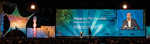 Hernando de Soto, economist, author, and president of Peru's Institute for Liberty and Democracy, spoke about the power land title documentation gives to the poor. He explained geospatial technology as a catalyst for landownership reform, a concept he believes can help those living in third-world countries overcome poverty. (See "