Fall 2009
Fall 2009 |
|||||||
|
|
|||||||
GIS for Renewable Energy |
|||
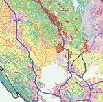
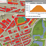
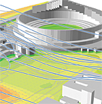
GIS is being extensively used in the quest to find and develop renewable energy resources, such as wind, solar, geothermal, and biomass energy. GIS is also being used to search for the best locations (considering natural and cultural resources) and to find the best corridors for transmission and distribution of resources. GIS technology is supporting and underlying the progress of this monumental change. GIS is not only improving the way we produce and deliver energy but also changing the way we view our earth's resources. This issue of ArcNews explores some of the ways organizations around the globe are using GIS to foster renewable energy initiatives. See the following articles.
|