
Today it seems that no conversation about information technology (IT) is complete without a discussion about big data, the cloud, or the consumerization of IT. However, arguably, the most impactful trend to hit IT has been analytics—both in media buzz and in corporate investment. Since the publication of Thomas Davenport and Jeanne Harris’s book Competing on Analytics: The New Science of Winning in 2007, both private- and public-sector organizations have been sold on the notion that they need to leverage analytics on their data to gain insight and drive decision making.
Business analytics has now become pervasive in most large public- and private-sector organizations. Current estimates are that 97 percent of large companies leverage analytics, with over 100 million users worldwide. Users come from across all functional areas, from executives to line operations and from managers to knowledge workers.
These analytic systems basically turn an organization’s data into actionable information by discovering and illustrating patterns, trends, and relationships in tabular business data. Typical output is in the form of statistical reports that summarize tabular data and sometimes display this data in graphs and charts. Analytics are often implemented as independent business intelligence (BI) systems but can also be part of larger enterprise systems, like customer relationship, enterprise asset, and resource management systems.
Business Analytics and Geography

There is a growing realization that by adding geographic location to business data and mapping it, organizations can dramatically enhance their insights into tabular data. Maps and spatial analytics provide a whole new context that is simply not possible with tables and charts. This context can almost immediately help users discover new understandings and more effectively communicate and collaborate using maps as a common language. While this geographic aspect has been largely absent from business analytics solutions, many organizations would like to incorporate it into their operations.
For years, a few progressive organizations have integrated maps and spatial analytics with their business data using GIS technology and netted powerful results. This approach has not become widespread because of the expense of custom integration with enterprise systems and because the capabilities of GIS are beyond the technical knowledge of the business analytics users.
A second approach has been the use of consumer web mapping technologies. This has likewise been problematic because of both difficulties with enterprise integration and a fundamental lack of needed capabilities.
Location Analytics—The Missing Perspective
Industry analysts are suggesting that the demand for mapping and geographic intelligence is emerging as an important segment of the business analytics software category. This interest is reflected in the fact that spatial visualization is one of Deloitte’s top 10 technology priorities of 2012. This new segment is being called location analytics and is focused on thematic mapping and spatial analysis for the world of business analytics. This solution space involves simple mapping and spatial analysis capabilities that work directly with business analytics packages and enterprise data systems with no custom integration efforts.
Esri Location Analytics—Esri Maps
Esri has recently built a simple and powerful solution for the location analytics space known as Esri Maps. This product complements and extends the leading business analytics products, such as Cognos, MicroStrategy, SharePoint, and others. Esri Maps supports easy-to-use mapping and spatial analytics. These capabilities are complemented with a full library of geographic content for enrichment that makes Esri Maps simple to use and inexpensive, and users can immediately make maps of data contained in business analytics systems. Esri’s direct integration with leading business analytics platforms means there is no cost for integration or ongoing maintenance. Also, because it is built using ArcGIS (Esri’s core technology platform), it can provide powerful GIS analytic capabilities and make use of other GIS investments in an organization.
Specific capabilities include the following:
- Mapping visualization: Point, color-coded, temporal, clustered, heat maps
- Spatial analytics: Bidirectional interaction, map filtering, proximity, custom area (drive time, trade area), and advanced analysis tools (geoprocessing)
- Geographic information enrichment: Basemaps, imagery, demographics, consumer and lifestyle data, environment and weather, social media, business, etc.
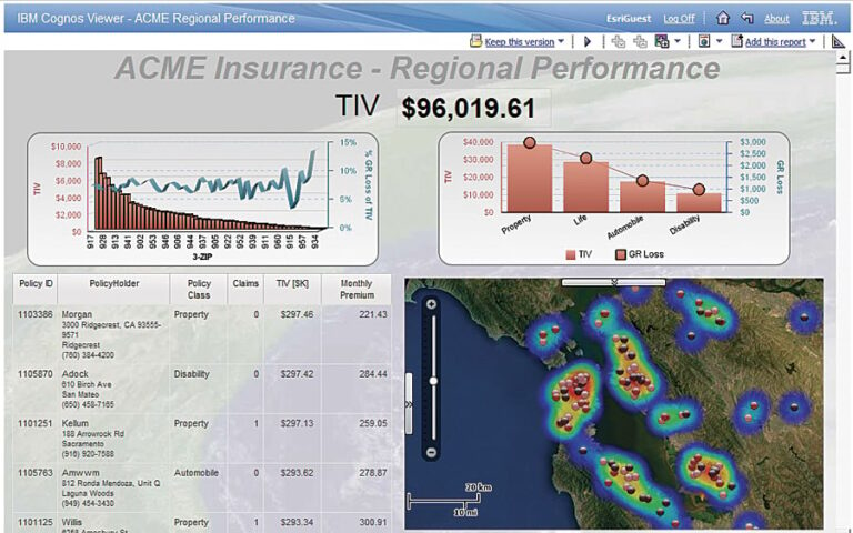
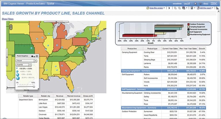
Esri supports multiple business analytics platforms. For example, Esri Maps for IBM Cognos delivers maps, spatial analytics, and geographic information to the IBM Cognos BI environment. Similarly, Esri Maps for Office, a feature of ArcGIS Online, delivers complete location analytics capabilities to Microsoft Office users [see “Esri Maps for Office Is Now Available.”].
The Esri technology augments and extends leading enterprise technology, like BI, customer relationship management, and enterprise asset management, providing mapping, spatial analytics, and geographic data enrichment in a complementary and nondisruptive manner. Users of these systems benefit from enhanced insight into their business data without leaving the business system or changing their information workflow—making these systems more impactful and effective for the users, as well as the business at large.
Enterprise Implications of Location Analytics
While Esri Maps provides a location analytics solution for business analysts, this capability is also part of a larger web mapping platform (ArcGIS Online—arcgis.com) that provides enterprise mapping and geographic analysis services for an entire organization. ArcGIS is used to share, visualize, and analyze all sorts of organization data using geography as a common framework. This system can also dynamically integrate (mash up) all sorts of data, including data that has been mapped using location analytics. When integrated with the growing volume of geospatially referenced data available on the web, whole new insights begin to emerge.
ArcGIS Online is helping enterprises extend the concepts of simple location analytics into whole new areas of information sharing; communication; collaboration; and, ultimately, better decisions. In the private sector, this capability is helping companies be more efficient and create a competitive advantage. In the public sector, it means more effective, transparent, and efficient services.
Location Analytics and Enterprise GIS
The Esri Location Analytics platform is designed for business analysts who spend much of their day using tools such as BI and Excel to see patterns and relationships in transaction data. They want self-service mapping and simple spatial analytics that are delivered within the analytic systems they use every day. These users will drive the proliferation of location analytics across the organization.
GIS professionals are in a unique position to help these analysts. They are already creating useful frameworks, data, and map layers that let non-GIS professionals, knowledge workers, and anyone in the organization start to use location and geography to make better business decisions.
They can also support this new community and help integrate and leverage their capabilities with other enterprise data to maximize the positive impact.
The integration of mapping and geographic intelligence across the entire enterprise will reinforce and leverage the mission of GIS professionals, particularly in transforming the way organizations leverage geographic knowledge.
For more information, visit https://www.esri.com/en-us/location-intelligence/overview.