Spring 2002
Spring 2002 |
|||||||
|
|
|||||||
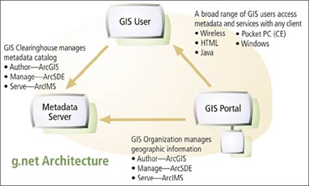
What Is the g.net Architecture? |
||||||
|
In 2001, Esri began to talk about g.net--a new architecture for sharing and using GIS information from distributed sources. This article presents a more detailed look at g.net--its origins and relation to Spatial Data Infrastructure (SDI), benefits, and implementation in ArcIMS 4 and ArcGIS.
BackgroundGIS has long been recognized as an integrating technology that can bring highly disparate data into a common map display. Overlaying layers of different data in a common geographic space allows you to integrate and derive new information to help you solve problems and to work more efficiently and effectively. GIS has become an essential tool when information integration is critical. It works with geographic information from many sources to support a broad range of applications. GIS can repurpose information for new applications that go beyond the data's original intent. For example, information compiled for land records management can be used for environmental applications, utilities, emergency response (E911), homeland security, and many other applications. There is widespread recognition that the data layers and tables in most GIS implementations come from multiple organizations. An organization typically develops some, but not all, of its own spatial data content. At least some of the layers will be from external sources. Thus GIS data management, by its very nature, is distributed among many users. GIS requires a distributed information system concept to manage and share geographic data.
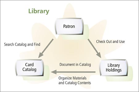
Because GIS users are hungry for quality geographic information, there is a fundamental need for users to share their data. Today, thousands of organizations worldwide invest billions of dollars annually automating and integrating map information for their focused GIS projects. Their need for up-to-date geographic information drives these efforts. Searching for a Common FrameworkWhile the common vision is to share this information, most geographic data sets remain inaccessible to external users for a variety of reasons. One of the main reasons is the lack of a common framework for sharing information about spatial data. Imagine a large public library without a card catalog or any systematic organization of the materials. It would just be a pile of books--a collection of immeasurable value with no means for readily finding the information that you need.
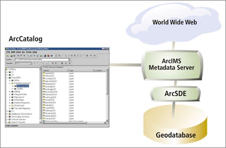
Many GIS organizations are finding themselves facing a similar dilemma--vast resources of geographic information are available, but the task of finding exactly what you need and knowing the quality and currency of the information is daunting. New Metadata Server in ArcIMS 4Modern GIS requires a mechanism for sharing geographic information much like libraries do. This requires tools and methods for cataloging GIS information as well as tools to publish the catalog and search it for relevant content. This catalog function is implemented in the new ArcIMS Metadata Server, enabling GIS users to manage metadata in a catalog and to search for geographic information. The Metadata Server is available in the ArcIMS 4 release, which was released in spring 2002 (see ArcIMS 4 Offers Significant New Capabilities and Extensions and ArcIMS and ArcGIS Combine to Bring Spatial Metadata to the Internet). Spatial Data InfrastructureGIS professionals are learning about the benefits of a Spatial Data Infrastructure (SDI). The SDI, developed by the United States and other national, state, and local governments, promotes the vision of a framework for GIS users to openly share geographic information with one another. The SDI is meant to address the needs for users to interconnect their existing GIS nodes across the Internet (and in many cases over secure networks) in order to share information with one another openly (i.e., based on standards). 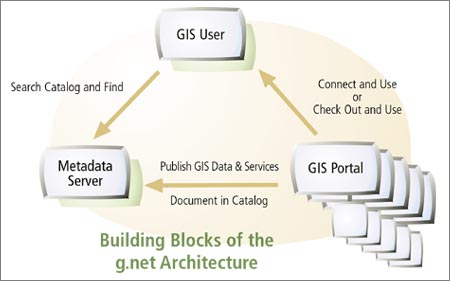 What Are NSDI and GSDI?Many people are familiar with the term NSDI, or National Spatial Data Infrastructure, a concept defined as the technologies, policies, and people necessary to promote the sharing of geospatial data throughout all levels of government, the private and nonprofit sectors, and the academic community. Recent discussions have revolved around the GSDI, or Global Spatial Data Infrastructure, which describes a framework for data sharing at the global level.
SDI Building BlocksA Spatial Data Infrastructure is built from three fundamental building blocks.
In practice, each node in an SDI would be built to provide one or more of these three capabilities. For example, a city might provide a catalog referencing the available data and services at its Web site along with a series of data and mapping services. A small GIS shop would be able to access and use those services in their ArcView seat across the Internet. In another case, a state government might provide the metadata catalog describing its services as well as data and services at other GIS portals within the state. The state might also publish GIS Web services with a set of HTML clients to access various Internet map and data services. At its most basic level, a Spatial Data Infrastructure is realized through a catalog holding metadata about available data and services. As the number of participating organizations and users grow, so will the numbers of entries and complexity of the metadata catalog. The role of a metadata server and search tools becomes more critical. What Is g.net?g.net is an architectural vision for how Esri users build parts of and participate in a Spatial Data Infrastructure. g.net describes how ArcGIS, ArcIMS, and other Esri software technology are used.
What Can Users Do with g.net?g.net and SDI concepts play important roles at a number of levels in the GIS community. g.net is flexible. The building blocks can be used interchangeably. Following are some of the possibilities for deploying g.net.
|