Spring 2010
Spring 2010 |
|||||||
|
|
|||||||
AZRocks! GIS for the Avid Outdoor Climber |
|||||||
Highlights
John Scully, a student in the Masters of Advanced Study in GIS program at Arizona State University and an enthusiastic outdoor rock climber, had noticed over many years that known climbing sites didn't have exact locations, making it impossible to map them electronically. Unfortunately, documenting locations and specific information about crag sites has not been a common practice among perpetual climbers. No matter how many different sources, such as Web sites, books, etc., he searched through, most directions came in the form of local knowledge, like "past the third cow and then turn right at the big rock." These directions were only vaguely acceptable when printed and physically read aloud in the car. While he had not expected an address for each, he knew that having latitude and longitude measurements would make getting to the climbing sites infinitely easier, leaving more time for the actual climbing. As he collected latitude and longitude points for the known sites, he also noticed that many had become increasingly worn from overuse and several had closed for various reasons. He wondered if there were any sites that had not been explored yet that might reduce the impact on the currently known sites.
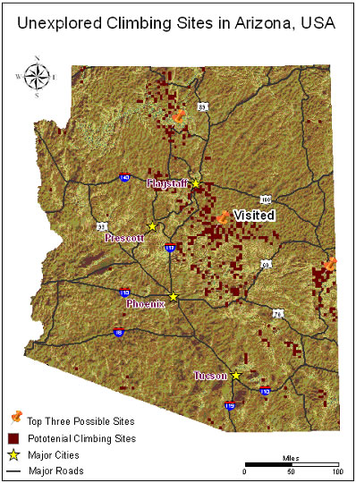
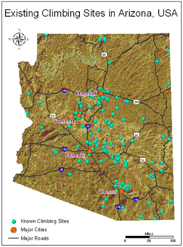
Having been exposed to ArcGIS Desktop software through his master's program, Scully knew that he could easily map the points he had collected and run an analysis that would allow him to search for new sites. He helped create the AZRocks! rock climbing group to search for and analyze potential climbing areas based on several criteria that he thought were extremely important. Using his knowledge of the various aspects of rock climbing and their importance, the group decided that an ideal climbing location possessed a limestone, dacite, or volcanic lithology; a height of around 1,000 feet; a location near a river, stream, or creek; and a maximum hiking distance of two hours from the nearest road. After collecting Arizona state and county boundaries, hydrology, transportation, property ownership, U.S. Department of Agriculture (USDA) Forest Service access roads and trails, lithology, and hillshade shapefiles, the group gathered a total of 127 known sites.
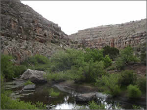
The team members then used ArcGIS to identify and analyze the distribution of known sites and pinpoint potential sites. They applied a ranking system to the potential sites, narrowing them down to the top three locations for the physical exploration needed to assess the quality of the rock surface. In Wildcat Canyon, the favored of the potential sites, the team members surveyed two separate areas using a handheld GPS unit. Comparing the locations of the projected sites with the actual sites, they found that site A was offset by 7.4 miles from the actual site, and site B had a difference of 2.5 miles. While both sites had the correct requirements based on the ranking system, Scully determined that the quality of the rock was highly suitable for further investigation. This is a huge step forward for the sport of rock climbing in Arizona, and the team is excited about the possibility of expanding its analysis further into the Four Corners region of the United States, where Utah, Colorado, Arizona, and New Mexico meet. More InformationFor more information, contact Sherry Lehmuth (e-mail: sherry.lehmuth@yahoo.com) or Breanna Buswell (e-mail: breannabuswell@gmail.com) or John Scully (e-mail: jscully@asu.edu). |