Spring 2010
Spring 2010 |
|||||||
|
|
|||||||
Road Status and Damage Assessment Tool Aids Emergency Operations in New York |
|||||
Highlights
New York State comprises 62 counties and more than 114,000 miles of public highways and roads. Geography varies widely across the state. The New York City metropolitan area dominates the Downstate Region of New York, and other large cities are spread across the state, including Albany, Buffalo, Rochester, and Syracuse. The Adirondack and Catskill regions are covered with mountain peaks and lush forests. Much of the remaining area of New York, including the central Finger Lakes and western New York, are largely rural and dotted with small communities, farms, and wineries.
The New York State Department of Transportation (NYSDOT) is responsible for more than 15,000 miles of state-owned roads, which vary from divided multilane interstate expressways to two-lane roads in rural areas, as well as all 20,000 bridges in the state. When a weather event or other incident that has a major impact on the highway system of one or more New York counties forces the governor to declare a state of emergency, NYSDOT resources are activated to assist in assessing and repairing damage to all public highways, including local streets, in those counties. During emergencies, it is critical for NYSDOT to be able to collect and report current road status and damage assessments in a consistent and timely manner. This information enables NYSDOT supervisors and managers to deploy limited department resources most effectively. In addition, NYSDOT has a responsibility to provide current road status information and report on the progress of response activities. Until approximately January 2008, NYSDOT had used its now legacy GIS tools to assist with emergency response for many years. Since the mid-1990s, one GIS application, the Emergency Road Status tool, had been used in the field by assessment teams to report the current status of the highway network using shapefiles. The system was simple to use and effective for the most common events in the Northeast, such as severe snowstorms. Then, when widespread flooding hit New York in June 2006, NYSDOT quickly developed a server-based application, the Damage Assessment Reporting System (DARS). DARS provided assessment teams with a browser-based form to enter detailed reports on damaged highway infrastructure, including the feature (e.g., culvert, bridge, pavement), the location, the type of damage (e.g., culvert plugged, culvert washed out), and other related information. An Internet management service provided an operational map of assessments collected with DARS. Each of these systems quickly highlighted the shortcomings of the other. The Emergency Road Status tool did not have the functionality to collect detailed damage assessments and required too much time and effort to transmit reports to the main office. DARS lacked the more intuitive map-based interface for data entry and required an internal network connection. Assessment teams that could not connect to the Internet would not have direct access to the application. In late 2007, NYSDOT's GIS group began work with Esri Business Partner Fountains Spatial, a GIS consultant in Schenectady, New York, to develop the Road Status/Damage Assessment (RSDA) system. RSDA would be a single GIS-based application that would improve on the functionality of the legacy systems to fully meet the department's emergency data collection requirements. As a foundation technology for the application, NYSDOT and Fountains Spatial quickly settled on the ArcGIS Engine development environment to fully leverage ArcObjects and the geodatabase. The primary component of the Road Status/Damage Assessment system is the field tool. The user interface includes the map, basic navigation tools, and separate interfaces for coding road status on the street network and point-located damage assessments. The RSDA field tool allows assessment teams to compile road status and damage information in a local file geodatabase without a network or Internet connection. The contents of the pull-down menus are based on domains in the RSDA geodatabase, so adding a new damage type to the application requires a simple geodatabase change rather than code changes. The field tool is also capable of using GPS coordinates to find a current location or place a damage assessment location.
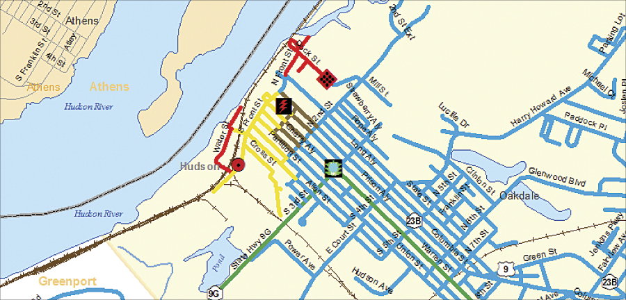
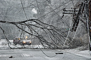
A major goal for the project was to minimize the lag time between obtaining a report in the field and providing that report to decision makers in the command centers. The development team accomplished this by providing communication between the RSDA field tool and a multiuser geodatabase. When an NYSDOT network connection is available (through a field office or secure VPN), RSDA will transfer new and revised reports to the enterprise geodatabase using the Upload tool. This capability greatly improves reporting speed. The first true test of the Road Status/Damage Assessment tool came in December 2008 when an ice storm severely crippled New York's Capital District and surrounding areas. Columbia County was hit especially hard with downed trees and power lines, effectively shutting down much of the state and local highway system. The emergency operations center (EOC) began sending out assessment teams with RSDA on Sunday, December 14. Comprehensive information on the status of the highway system, as well as detailed damage assessments, was uploaded to the enterprise geodatabase, and the road status was continually updated during the week. Decision makers in the main office incident command center and the local EOC could easily view this information in the ArcGIS Server software-based RSDA Viewer. The NYSDOT emergency operations center used information collected by RSDA to prioritize repair and cleanup work. The map-based view of damage assessments provided crews with a view of problems nearby, allowing more work to be accomplished on a single trip. The RSDA Viewer was provided (via Citrix) to Columbia County's EOC. By using the same operational picture at both locations, the state and county were better able to coordinate their response activities. RSDA reports also allowed NYSDOT to communicate the condition of the highway system to emergency services, utility providers, and the community. For example, the EOC helped school superintendents make decisions on school closings by providing summaries of road closures and conditions for each school district. After the event, emergency operations staff gave RSDA high marks for assisting in their emergency response efforts. The EOC reported that new teams with no RSDA or GIS experience had a working familiarity with the application with just 5–10 minutes of instruction. Almost 100 damage assessments and road status updates for every public road in Columbia County were successfully uploaded to the enterprise database. Much of the success of the RSDA implementation may be credited to the iterative development process. Samples of the user interface were built in the first three weeks, enabling the team to make good early decisions about workflow and usability. A few weeks later, a prototype was provided to a pilot group of individuals responsible for emergency operations for their comments and feedback and incorporation into subsequent development. Before a final version of the tool was accepted and deployed, NYSDOT's emergency operations center used a prerelease version of RSDA in a full-scale, statewide drill. Again, the project team evaluated and incorporated comments from the user community in the final version. Developing applications for emergency response is a special challenge. The system must be easy to deploy and use and must work as designed under difficult circumstances. The response to the ice storm demonstrated that NYSDOT achieved its goals for the Road Status/Damage Assessment system. Use of GIS technologies was key to meeting these goals. More InformationFor more information, contact Kevin Hunt, GISP, NYSDOT GIS manager (e-mail: khunt@dot.state.ny.us). |