Spring 2010
Spring 2010 |
|||||||
|
|
|||||||
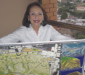
Rosario C. Giusti de P�rez Brings Urban Planning to the Slums of Venezuela |
|||||||
|
Rosario C. Giusti de P�rez, architect and urban designer, exemplifies the importance of combining the human element of concern with the capabilities of technology to turn the tide of despair to one of hope and benefit for the community. Because of her many years of commitment to helping improve the quality of life in the slums (barrios) of Venezuela, Esri recognizes Rosario C. Giusti de P�rez as a GIS hero. Despite the fact that Venezuela is an oil rich nation, approximately 50 percent of its people live in poverty. Those in urban areas have constructed shantytowns with homes made of plywood, corrugated metal, and sheets of plastic. Giusti de P�rez does not see these neighborhoods as targets for the bulldozer but rather as communities whose residents need to be involved in planning and redevelopment. Many cities do not consider these squatter lands as communities and consider demolition to be a solution to urban blight. But this ruthless approach of displacement creates disorder, increases crime, and adds to the misery of poverty. A slum is more than corrugated tin and plastic; it is human faces, neighborhoods of people with social structures that protect and support their communities. Giusti de P�rez has spent the last 10 years working with people and using GIS as a means to understand how urban squatter developments are organized, which in turn offers the foundation for devising improvement efforts. "When visualizing squatter developments as cities within cities, GIS helps us see the internal connections that constitute the barrio's underlying order, which is fully perceived by the residents of the area," notes Giusti de P�rez. "To fully understand social networks within a community, planners need to obtain information directly from the community. Inhabitants have knowledge about who belongs to each social group and how social groups connect. This is valuable data with a geographic element." Giusti de P�rez advocates an approach that recognizes the slum inhabitants as being deeply rooted in their communities. As people who have a sense of belonging, they are territorial and fear relocation plans. People want to remain where they have their social relations. Giusti de P�rez, who holds a master's degree in urban design, initiated an approach to developing urban planning models that includes input from residents so that squatter settlements can become an asset to the city. "We need to collect information that is significant to residents," says Giusti de P�rez. With this thought in mind, Giusti de P�rez developed a framework for sustainable improvement planning with the ultimate goal of advancing the residents' quality of life. The objective of this planning approach is to introduce what she calls "friendly interventions" into the as-built environment. In this model, residents agree on behavioral and building rules, such as sharing waste disposal to maintain clean open space and limiting building height so as not to impede natural light. These are simple resolutions. Of course, squatter communities have much more complex issues, such as unstable slopes, inadequate utilities, and insufficient schools. GIS allows planners and residents to visualize the answers to the questions they are asking: What would happen if we put a concrete fascia on the slope? How can we run sewers into this area? Where is the best location for an elementary school?
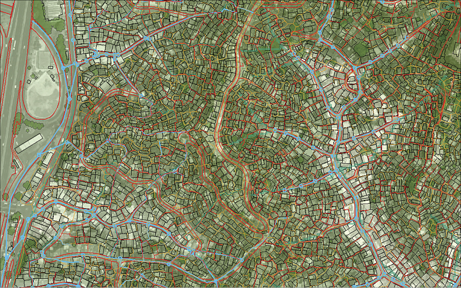
Giusti de P�rez uses GIS to create what-if scenarios and generate maps that show what a concept would look like, whom it would affect, and how it would help. These images go a long way in providing information that engenders community participation in planning. The maps that Giusti de P�rez and Ram�n A. P�rez, a GIS professional, were creating in the 1980s using Esri's ARC/INFO began to be noticed. These GIS maps were instrumental in winning several national competitions against other urban planners who used CAD. Soon, several Venezuelan government institutions recognized that GIS is a clever tool. "Barrio analysis is very complex," explains Giusti de P�rez. "GIS can take this mess of barrio data and organize it into something that makes sense. We would select a barrio, meet with its community leader, and explain that we wanted to help. The community leader would then invite other people from the community to a meeting, sometimes at a school or sometimes just on a slab made of some odd building materials. Together, we would identify what they needed and prioritize their concerns." GIS was key to a three-year project in the barrio of Petare in Caracas to visualize and assess the area's urban built conditions and social networks. It proved essential to creating a sustainable planning strategy and for designing a development that fit both building and social needs within the conditions dictated by the geography of the site. With an ultimate goal of improving the quality of life, the urban planners worked with residents and identified 93 sectors within 82 hectares. Data included vehicular and pedestrian pathways, sector boundaries, social spaces, and built places. The group determined areas that were at risk for landslides and focused on building control policies for these areas. Community concerns varied. In the Petare barrio, the community's main concern was accessibility to urban facilities and infrastructure. Residents wanted better drainage and solid-waste disposal. Priorities that were included on another barrio community's list were drainage, open space for children, and lighting. Each project was unique.
"Sometimes we can do a little and sometimes more," explains Giusti de P�rez. "We make our presentations using GIS, and people are glad to see what their community looks like. We use the ArcGIS 3D Analyst extension to create visualizations that show residents what their community could look like if they implemented changes. Based on community input and planners' assessments, we created site analyses that helped communities successfully request government program funding." In 2008, Giusti de P�rez coauthored the book Analyzing Urban Poverty: GIS for the Developing World, published by Esri Press. In it, she and Ram�n A. P�rez offer a step-by-step approach to working with squatter communities and improving their neighborhoods. The authors provide several rules for using GIS to support sustainable communities. One rule is to create procedures for involving communities in collecting the information required for identifying their problems and opportunities. This will help planners with the problem of lack of data. Another rule is to identify the social relations and interactions of the populations with the open spaces in the community. This is more important than merely describing land use. Finally, the authors advise using ArcGIS Spatial Analyst ModelBuilder in hilly squatter developments to understand the rules of urban and social functioning and identify steep slopes, drainage patterns, and accessibility from the neighborhood to the city. Giusti de P�rez is hoping to expand the use of GIS models for urban redevelopment and promoting its capabilities to identify real, sustainable solutions for improving the quality of life for millions. She is truly a GIS hero. More InformationFor more information, contact Rosario C. Giusti de P�rez (e-mail: rosario@esriven.com). Ram�n A. P�rez is the founder and president of Esri's Venezuelan distributor, Grupo Esri de Venezuela, C.A. |
 The United Nations Center for Human Settlements reports that more than one billion people in the world live in slums and squatter settlements without adequate shelter and basic services. Worldwide, slums are considered to be residential areas in urban geographic areas that are inhabited by the poor. Because of these characteristics, urban planners can use GIS to manage geographic data about slum areas to show relationships, elevations, landmarks, slope, water sources, and other attributes that affect these urban populations.