Spring 2010
Spring 2010 |
|||||||
|
|
|||||||
ArcGIS Server Based Central Repository and Accessibility for Facilities Management
Taking Efficiency to the Next Level at City College of San Francisco |
|||||
Highlights
Attended by more than 100,000 students each year, City College of San Francisco (CCSF) maintains and uses 300 facilities spread across 11 campuses in the City of San Francisco, California. People of diverse backgrounds, ages, and occupations have attended the college since its founding in 1935. CCSF is one of the largest community colleges in the country, and the college confers the most associate degrees in arts and sciences in the state of California.
College facilities are managed by two departments: Facilities Planning and Buildings & Grounds. Traditionally, these departments relied on senior engineers and personnel to maintain facility information, which was shared through paper plots or word of mouth. Some existing paper floor plan plots were digitized a decade ago for general reference, but records of maintenance and upkeep of buildings remained firmly entrenched in paper-based methods. Although recent construction of several facilities introduced the use of computer-aided drawings, both departments lacked a system to easily manage and disseminate the data. This resulted in challenges when gathering information; time was lost searching for data and determining if it was up-to-date. The ability to decipher how many and where assets existed was difficult. The attrition of personnel was also a concern as valuable institutional knowledge was lost when staff members retired. Newly hired staff required a lot of time to learn about the facilities. Seeking a System for Data SharingCCSF needed a centralized and flexible system to help organize and deliver facility information. Part of the system needed to assist the college with correctly identifying the current level of physical accessibility in all classrooms and buildings according to the Americans with Disabilities Act (ADA). This required the collaboration of several additional departments across the campus to deliver all the information on a publicly available online Web service. After reviewing many software packages for functionality and ease of programming, CCSF chose ArcGIS Server. Says Mono Simeone, project manager, CCSF GIS Mapping Collaborative, "The software's scalability, performance and stability, enterprise capability, and built-in AJAX capability make it easy to manage and deploy." CCSF facility management staff contracted with i-TEN Associates, Inc., an Esri Business Partner located in Berkeley, California, which had previously digitized CCSF's facility data and made it accessible on an internal Web site. Several departments, including Facilities Planning, Buildings & Grounds, the Campus Police, and Information Technology Services, and the American Disabilities Act and Health and Safety committees worked together to create the system. Now GIS server technology stores, manages, and displays facility and grounds data in a central repository for everyone to use. From Paper to EmpowermentFirst, the team applied a data model to interior spaces or floor plans. ArcGIS Server, using an Oracle relational database management system (RDBMS), stores, edits, and displays the descriptive and spatial data accessible through a simple interface for both secure and public Web sites. Next, the team created Web applications with ArcGIS API for Microsoft Silverlight, an API for building cross-browser and cross-platform rich Internet applications on top of the GIS. The Web applications serve data for use throughout the college. "The creation of the applications was very straightforward," notes Simeone.
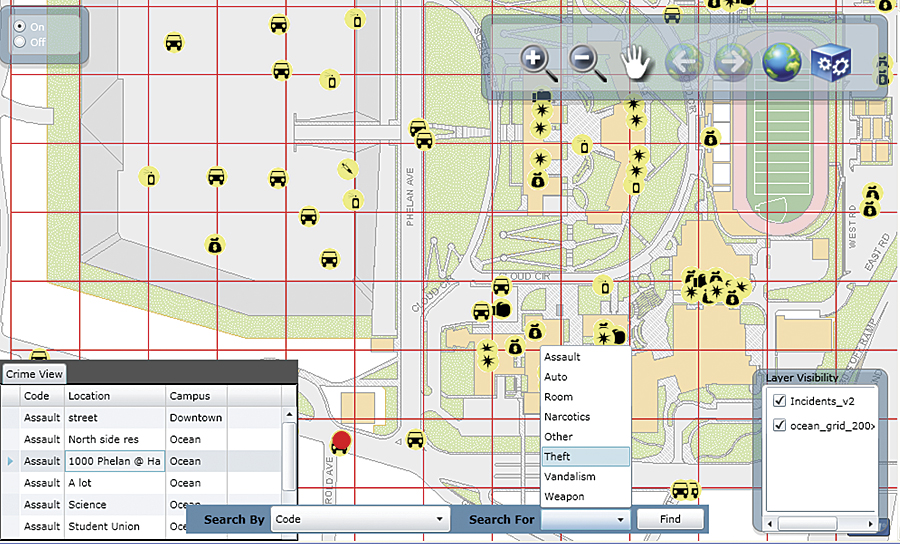
The first application provides access to ADA information at all campuses in the district. It displays features necessary for persons with mobility issues to navigate the campuses. These features include path of travel, parking for the disabled, accessible entrances, and elevators. The application offers several queries to find buildings, rooms, student services, and staff on campus. The result is a map with helpful features for navigation and a report on the room with a picture. The next iteration of the application will implement a routing service using ArcGIS, which provides point-to-point and optimized routing. This successful application led to more meetings with campus staff from Facilities Planning and Buildings & Grounds. There was a lot of interest in viewing utilities campuswide, including identifying individual features. An application was developed allowing staff members to use a secure intranet site to display all underground and some surface utilities. "This was the first time we have been able to view all the utility assets at one time," says Simeone. CCSF also has a campus crime application that allows incidents to be queried by campus, crime type, and date. Incidents within buildings are easily located using a unique space identifier from the GIS. However, incident locations occurring outside buildings are captured using a grid, or mesh, that covers the entire campus. Future plans include the development of a Web-based map service tool to capture x,y coordinate locations of incidents. GIS Exceeds ExpectationsSince the college maintains an Esri campuswide site license, CCSF was able to add new GIS seats and employ existing GIS-knowledgeable staff. Both of these factors made the application implementation easy and economical. The system now allows data to be centrally stored for more efficient management and sharing. Staff and administrators are able to view and query the facility data at any time from all over the CCSF campus. Departments can tailor a map service to meet their needs, and data can be updated and served to staff or the public in a timely manner. This implementation of GIS for facility management has exceeded the goals created by the college. CCSF hopes to introduce GIS and facilities management as even bigger parts of how the college operates, manages its assets, and serves the community in the future. More InformationFor more information, contact Mono Simeone, project manager, CCSF GIS Mapping Collaborative (tel.: 415-239-3988, e-mail: csimeone@ccsf.edu), or Shreepad Ranadive, director, Application Development, i-TEN Associates, Inc. (tel.: 415-516-8633, e-mail: shreepad.ranadive@i10assoc.com). |