Spring 2010
Spring 2010 |
|||||||
|
|
|||||||
Geographic Knowledge Helps Peacekeepers, Humanitarians
UN Uses GIS to Promote Peace and Provide Aid |
|||||||||
|
Founded in 1945 after the Second World War, the United Nations (UN) has a long history of working to maintain peace and security around the world. The international organization, composed of 192 member states, strives to improve relations among nations and protect human rights.
In the UN Secretariat alone, approximately 40,000 staff members work each day to implement UN programs and policies. From Darfur in western Sudan, Africa, to Lebanon, Haiti, and beyond, GIS is supporting those who work in departments and offices within the UN Secretariat so they can provide essential security for millions of people, as well as fragile institutions, emerging from conflict and recovering from humanitarian emergencies. Providing Geographic KnowledgeThe UN Cartographic Section (UNCS) is at the core of the UN Secretariat's geospatial initiatives. The UNCS staff provides geographic visualization to the Security Council sessions, analysis for the Department of Peacekeeping Operations and Department of Political Affairs, and cartographic support for the secretary-general reports. UNCS is also in charge of the GIS program of peace operations, managing GIS offices in 13 peacekeeping and political missions. Other information management teams, such as the GIS officers and cartographers in the Office for the Coordination of Humanitarian Affairs (OCHA), collaborate with UNCS to further extend the reach of GIS. Throughout the UN, decision makers rely on geographic information products to support highly sensitive and important decision making. GIS data and analysis are used for boundary delimitation and demarcation, field mission planning and operations, humanitarian intervention, logistics, resource allocation, and critical analysis and visualization for situational awareness and security.
GIS officers are assigned to most UN field missions (both peacekeeping and political), resulting in a robust enterprise capability whereby the UN is making a great impact on building peace and stabilizing operations. With enhanced geospatial abilities, improved operations have allowed the peacekeepers, humanitarian response teams, and other UN partners to operate with more actionable information in the field and achieve greater success. UNCS and other GIS teams within the UN Secretariat in New York City, New York, and in the field provide substantial GIS support to the decision makers, political analysts, information managers, and Security Council members, as well as operational GIS support, for mission planning, demining, peacekeeping, and humanitarian operations. Defining BoundariesEstablishing boundaries between countries is a prerequisite for peaceful neighboring relations. UNCS has been involved in many projects related to delimitation and demarcation between member states so that all parties have a clear understanding of their sovereignty limits. Using GIS, the UN has facilitated the definition of the Cameroon-Nigeria, Eritrea-Ethiopia, Iraq-Kuwait, Israel-Lebanon, and Turkey-Greek Cyprus boundaries. With the UN International Boundary Information System (UNIBIS) project, UNCS is working to create and subsequently maintain a worldwide geodatabase on international boundaries. It will depict, as accurately as possible, their geometry, status, claims, dates of treaty agreements, and reference materials. The boundary geodatabase uses authoritative sources of information, such as treaty maps, coordinates, rulings, treaty text, and interpreted satellite imagery. Developed by UNCS in consultation with other international experts on boundaries, UNIBIS highlights potential conflict areas to support conflict prevention activities and enhance readiness for assistance on boundary demarcation issues. Developing Peace and SecurityPeacekeepers deploy to war-torn regions where no one else is willing or able to go and prevent conflict from returning or escalating. Since the organization's inception, UN peacekeepers have undertaken 63 field missions, which, among many other things, enabled people in dozens of countries to participate in free and fair elections and helped disarm more than 400,000 ex-combatants in the past decade alone.
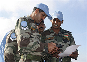
In response to a recommendation in the Report of the Panel on United Nations Peace Operations, GIS is now part of the UN peacekeeping infrastructure and is used throughout the range of activities that peacekeeping missions must perform. For example, GIS is a critical tool in the Darfur region of Sudan, Africa, where people have suffered great atrocities since conflict broke out in 2003. Since supporting the Darfur Peace Agreement in 2006, the UN continues to work closely with the African Union to bring peace to this conflict-ravaged area. The African Union/United Nations Mission in Darfur (UNAMID) is using GIS to implement the Darfur Mapping Project. Detailed information about the region was previously unavailable, so mapping the area at a scale of 1:50,000 gives the peacekeepers detailed topographic information they can use to optimize operational effectiveness and efficiency. The GIS infrastructure enables information flows across offices and field missions for coordinated support to the region. In Lebanon, after fighting erupted in 2006, the United Nations Interim Force in Lebanon (UNIFIL) began monitoring the cessation of hostilities, accompanying and supporting the Lebanese armed forces deployed throughout southern Lebanon, and extending humanitarian efforts. UNIFIL has since created the GIS-based Security Warden Information System (SWIS) to support UN security operations in the area. The goal of SWIS is to provide security and military response teams with accurate visual information related to staff locations, along with other important locations, such as UN positions, evacuation or gathering locations, and incident locations. This mission-critical system supports the safety and security of approximately 9,000 UN staff in southern Lebanon. Delivering Humanitarian Assistance
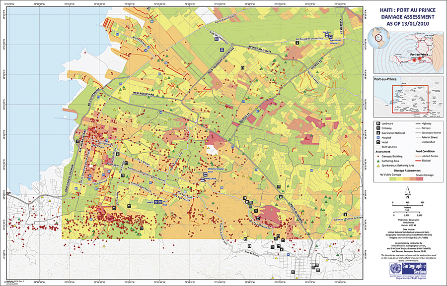
In addition to peacekeeping operations, the UN uses GIS to support another core mission—providing humanitarian assistance to people in need. OCHA, for example, uses GIS as a communication tool to evaluate the humanitarian situation on the ground as a natural disaster or complex humanitarian emergency unfolds. OCHA is responsible for the coordination of other humanitarian organizations that are grouped into nine humanitarian clusters: camp management, early recovery and reconstruction, education, emergency shelter, health, IT and communications, nutrition, protection, and water and sanitation. Most UN agencies, such as United Nations Children's Fund (UNICEF) and World Food Programme, also use GIS in their humanitarian assistance work. Mission in HaitiIn its recent response to the earthquake in Haiti, the United Nations Stabilization Mission in Haiti (MINUSTAH) and UNCS are heavily using GIS to enable situational awareness and support operations on the ground. The MINUSTAH GIS unit has made available its basemap data layers for public use. It is also providing support to other UN entities, nongovernmental organizations, and member states that have deployed to Haiti. UNCS has been focusing on providing the necessary support to MINUSTAH, as well as necessary information and situational awareness to senior management and UN entities around the world. It has created a GIS Viewer Web application to promote information sharing and situational awareness among all stakeholders. All relevant geospatial data received from various sources will be loaded into this application. Prior to the earthquake, MINUSTAH used GIS to help the country deal with a series of disasters, including violent demonstrations over food prices that led to the collapse of the government, four deadly hurricanes that affected nearly a million people in 2008, and a school collapse that took the lives of 100 children. Making a DifferenceStaff members in departments and offices throughout the UN are making a difference in the world—from championing peace and delivering humanitarian aid to supporting environmental management; monitoring and mitigating climate change; and enforcing international laws, such as the UN Convention on the Law of the Sea. The people of the UN take great risks in insecure situations to accomplish their missions and improve the lives of millions of people in need. In some of the most challenging environments and most remote areas of the world, where data, telecommunications, and energy are limited, they continue to succeed and use GIS to support their work. More InformationFor more information on how the UN is successfully using GIS, contact the UN Cartographic Section (e-mail: cartog@un.org). The contact regarding this article is Salim Sawaya (e-mail: ssawaya@esri.com). |