"Managing GIS"
A column from members of the Urban and Regional Information Systems Association
GIS Matters in 2012!
By Kathryn McSorley, GIS Specialist, Bergen County, New Jersey
We have all lived through the past two years of shrinking budgets and staff and wondered whether GIS still matters in 2012. "Of course it matters," is your first reaction. It must be those that don't understand GIS that place these burdens upon us to do more with less, as if we are master magicians. But still, how does one go about proving that GIS still matters? By succeeding.
Just because our resources have been reduced doesn't mean we are entirely hamstrung. There are still opportunities available to us as GIS managers to grow geospatial technology. During these fiscally unsure times, our GIS enterprises can benefit from some healthy pruning and allow us to refocus and think about new and innovative paths for us to explore. Here is my road map:
Clean out the clutter. This step hurts—I don't deny it. It's time to ditch all those old files and manuals you haven't used in a decade. This will help you reevaluate what is important to your operations and what is just eating up your resources. I have had the same office space for the last 18 years, and the only time I ever purged was when I was pregnant with my twins 4 years ago. So, when news broke of our offices moving, I was struck with dread. Moving is one of the most stressful events one can experience—and for many of us, our offices are a second home. Embracing the idea of thinning out my stash of Solaris manuals and ancient versions of ARC/INFO discs was the best thing I ever did. Be honest—how many of you still have them sitting in a cabinet, just in case we need to go back to command-line editing? Not only did this purging help me realize what I didn't need anymore, but it was a walk down memory lane, reaffirming what I have accomplished over the years by myself in that office. It also provided a chance to reflect on how far we've come. Recycling all the old equipment felt good too. I now have a nice tidy setup for my fleet of tablets where my old dinosaur of a digitizer once stood. During this process, don't forget to go through all those ancient digital files also—the cost associated with backup systems and disaster recovery for documents that have been replaced can add up quickly.
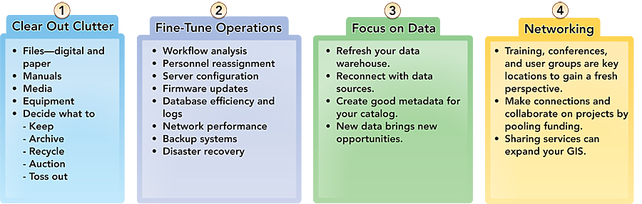
Here is a road map to an innovative, clean/mean local government GIS.
Fine-tune your operations. Think of this as preventive maintenance. Taking the time to make sure your essential services are working optimally will pay off when things pick up again. Once you have a clean slate and are devoid of clutter, take a look at your workflows and try to identify any changes that should be integrated. If you're unhappy with your process to update your parcels, now's the time to make it better. With staff reductions occurring throughout organizations, this is the perfect time to identify and implement those workflow changes. We simply cannot do the same jobs the same way. Take a close look at your servers and see if they are configured to work together in the most efficient way. Few of us have the luxury of unlimited server capacity and unlimited bandwidth, so a careful analysis of these can help pinpoint areas that need attention. You never know what you might discover when you get deep down into your databases and examine the logs. Working with smaller staffs, people are pulling double- or even triple-duty—IT guru, GIS analyst, and SQL admin all rolled into one! It's easy to overlook some of these settings when you're busy switching hats, and you could end up with a runaway log file that consumes most of your free disk space. Now might be the time to get some outside help in getting some of these performance issues addressed. You can help yourself by setting up a calendar of reminders for these tasks to keep your operations on track and your GIS a well-oiled machine.
Focus on data. In busy times, it's hard to keep tabs on all the rich data sources out there. Make this a priority when projects are put on hold. Reach out to your local data warehouses to ensure that you have all the most current data available for your area and that it has properly documented metadata. On this point, I have a confession. I am a metadata flunky. I teach all my students about the importance of it, but when it comes to keeping metadata up-to-date, I am a flop. Perhaps 2012 will be my year to redeem myself to my esteemed colleagues who have patiently and fervently preached the values of good metadata. Truly though, data is what drives our GIS, no matter what we use it for. If you want to immediately increase the value of your GIS, tapping into new sources of data can open countless new avenues for applications and usage by your organization. Nothing shouts success better than a brand-new, shiny web app with cool new data!
Networking is an investment in your GIS future. When you network extensively with other departments, you can develop an action plan to follow when resources become available, and you will identify ways to pool money for projects that are mutually beneficial. This may seem like an obvious step, but in a budget crunch, we see our travel and training budgets get vaporized. This can stifle some opportunities to network. Staying home isn't the answer. You need to network more and see more examples of GIS at work. Conferences, either national or regional, offer an incredible value in a tight economy, because they draw people together in a learning environment that fosters the exchange of ideas. Local user groups are also a great way to start extending your connections to work on collaborative projects. Shared services is an approach that is gaining popularity in New Jersey. As a method to reduce redundant costs, municipalities will pay another government entity a fee-for-service for GIS that is customizable to the municipality. This can bring in a revenue stream for a GIS department that has made significant investments in hardware and software and helps offset personnel costs.
So, after you've cleaned your office, revamped your workflow diagrams, spruced up your data catalog, and met some creative thinkers who make you want to step on those boxes you've been in all your life, enjoy the feeling of accomplishment and success. Your actions during these uncomfortable times will prepare you with a GIS that is efficiently tuned, thoughtfully designed, and ready to hit the road at high speed when the economy turns the corner.
About the Author
Kathryn McSorley, GISP, is the GIS specialist for the Bergen County, New Jersey, Department of Health Services Environmental Division. She graduated from Boston University with a bachelor of arts degree in urban and regional geography and earned her master of arts degree in geography from Hunter College, City University of New York. In 2010, her work on an innovative mobile environmental health application was recognized with an Esri Special Achievement in GIS Award. She is the past president of the Mid-Atlantic Chapter of URISA (MAC URISA) and conference chair of MAC URISA 2012. She is an adjunct lecturer at Fairleigh Dickinson University and a busy mom of three.
For more information, contact Katy McSorley (e-mail: kmcsorley@co.bergen.nj.us).
Read other articles in this series.