


|
|
||
|
|
|
|
|
|
Announcing ArcIMSOne of the key features of Esri's new Internet mapping system, ArcIMS 3, is the ability to establish a common platform for exchange of Web-enabled GIS data and "As a publishing technology, ArcIMS features unique capabilities for supporting a wide variety of Esri clients," says Szukalski. "As a serving technology, ArcIMS includes a wide variety of Esri serverside technology and provides a unique data integration potential via certain clients." ArcIMS ClientsIn-the-box ArcIMS includes HTML and Java clients, plus a full suite of other Esri clients such as ArcExplorer, ArcPad, and other devices. ArcExplorer 3 (Java edition) is included with ArcIMS and will be available for free download from Esri's Web site at www.esri.com/arcexplorer. Users can also develop custom desktop applications using the ArcIMS connector interface. Adds Szukalski, "One of the lesser known features of ArcIMS is that you At right, ArcIMS clients offer unique data opportunities for integration of raster and vector data as well as local and Internet data. The ArcIMS Java and HTML client viewers process data on the client machine, performing many tasks without further interaction with the server. "Some of these clients are free and lighter weight in capabilities, while others offer full, professional-level capabilities," says Szukalski. "ArcIMS offers a large variety of options both on the serverside and on the clientside, which really distinguishes this product from other Internet mapping products." Geography Network BackboneThe powerful integration capabilities of ArcIMS have created the enabling technology for the Geography Network, a World Wide Web-based integration of GIS data and services. "ArcIMS is the backbone of the Geography Network," says Szukalski. "It's the ArcIMS technology that makes the Geography Network become a reality." (See Geography Network cover story.) Through the Geography Network, organizations can subscribe to data and services. Some of the data and services are free, and others are fee based; however, these can all be combined into virtual applications. For example, a city worker can integrate local parcel data with flood information from FEMA, elevation information from USGS, or environmental data and combine this information on their desktop to perform specialized query and analysis. "Now even those who don't have the means or need to have their own GIS departments, software, and/or staff can empower themselves with GIS through the Geography Network," states Szukalski. ArcIMS ServersThe ArcIMS server technology is part of a multitier architecture. The ArcIMS framework consists of clients, services, and data management. (See ArcIMS Architecture.) 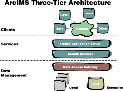 "The wide variety of supported clients and the server potential are what sets ArcIMS apart from other Internet GIS competitors," says Szukalski. "The clients that ArcIMS supports and the serverside capabilities are unparalleled by any other solution—not to mention the opportunities for data integration." The serverside includes core services, and there will be more services added in the future. ArcIMS ManagerArcIMS also features the ArcIMS Manager, a suite of Web pages to access all ArcIMS serverside functions and tools. "The ArcIMS authoring and site management tools provide an easy-to-use site management environment such as a console for starting and stopping map services, as well as a screen for viewing performance stats on serverside distribution," adds Szukalski. In addition, tools can be distributed to various administrators and can be run in a combined browser interface or as stand-alone Java applications. ArcIMS 3, which supports Windows NT and UNIX platforms, is now available. Esri users who have licensed ArcView Internet Map Server (IMS) or MapObjects Internet Map Server (IMS) solutions may qualify for a no-cost migration offer to ArcIMS 3. For more information on ArcIMS 3 and the upgrade offer, please visit Esri online at www.esri.com/arcims or contact Esri at 1-800-447-9778. Outside the United States, please contact your local Esri distributor. Next >> ArcIMS Architecture |
 services. According to Bernie Szukalski, ArcIMS product manager, ArcIMS is more than just an Internet mapping solution—it's a framework for distributing GIS capabilities via the Internet.
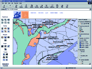 can build custom Visual Basic and Visual C++ applications that use ArcIMS services."
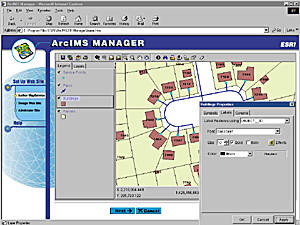 Through the ArcIMS Manager, users follow simple instructions to author, design, publish, and administer Internet map services. (See