Summer 2002
Summer 2002 |
|||||||
|
|
|||||||
ArcIMS 4 Integrates with ArcGIS |
|||
|
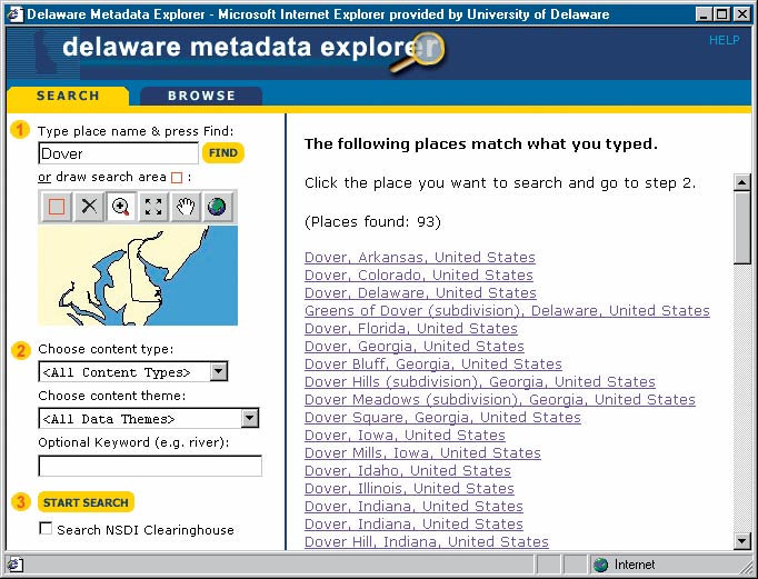
ArcIMS 4, which began shipping in May 2002, offers major new enhancements and more closely integrates ArcIMS with the ArcGIS product family.
ArcIMS ArcMap ServerOne of the most significant features included in ArcIMS 4 is the new ArcIMS ArcMap Server. ArcIMS ArcMap Server is an important addition to any ArcIMS site, extending core ArcIMS capabilities to include ArcGIS data access and cartography. Using ArcIMS ArcMap Server, an even wider variety of data formats, such as coverage annotation, CAD drawing files, and geodatabases, can easily be served over the Internet. In addition, ArcMap Server delivers the advanced cartographic capabilities of ArcGIS to the Internet and offers high-quality, "print-on-demand," Web-based mapping. Metadata ServicesAnother significant feature included in ArcIMS 4 is the ability to create a central repository for publishing and browsing metadata over the Internet using ArcIMS in conjunction with Esri's ArcSDE and ArcGIS Desktop software products. Metadata can easily be authored using the ArcGIS ArcCatalog application, published to an ArcIMS Metadata Server, and then quickly searched by others. Along with metadata services, ArcIMS 4 users also receive the Metadata Explorer, which is a JavaServer Pages (JSP) application that can be used to build a customized, browser-based means of searching for data. Java SupportAs part of Esri's strategy of offering more GIS capabilities for the Java developer, ArcIMS now comes with a Java Connector, which allows developers to program Java clients and Java applications that use a set of JavaBeans. Included are a new object model, JSP tag libraries based on the new object model, and samples. ArcIMS 4 also includes new JSP-based administration tools along with the standard HTML-based tools for greater flexibility and cross-platform support. New PlatformsUsers now have an even wider choice of operating systems on which to run ArcIMS. With the release of ArcIMS 4, the software is supported on Linux and HP-UX operating systems in addition to existing ArcIMS support on IBM AIX, Microsoft Windows, and Sun Solaris platforms. ArcIMS Route ServerArcIMS Route Server is an ArcIMS extension that offers the ability to incorporate fast, accurate routing and point-to-point driving directions into Web sites powered by ArcIMS. With ArcIMS Route Server, users can customize map output, use image rendering and feature streaming, and perform spatial and attribute queries. It is compatible with both ArcIMS 3.1 and ArcIMS 4. For more information on all of these new ArcIMS capabilities, visit www.esri.com/arcims or call Esri at 1-800-447-9778, call your Esri regional office, or contact your local reseller. Outside the United States, contact your local Esri distributor. |