Summer 2002
Summer 2002 |
|||||||
|
|
|||||||
Rescuing a Sewer Pipeline Avoids Catastrophe in San Juan, Puerto Rico |
|||||||
|
Carving a path through San Juan, Puerto Rico, on its way to the Atlantic Ocean, is the Rio Puerto Nuevo that, along with its tributaries, drains more than 24 miles of highly developed and densely populated land. Along its route, the river passes the Puerto Nuevo Wastewater Treatment Plant, the primary sanitary treatment facility serving the metro area of San Juan. Draining all of the sewer pipes from the City is the San Jose Trunk Sewer (SJTS), nearly a mile of 90-inch diameter reinforced concrete pipe, installed in the 1950s and still serving as one of the City's primary sewer lines that discharges wastewater to the treatment plant. Before releasing the wastewater to the plant, the SJTS crosses beneath the Jose De Diego Expressway and the Puerto Nuevo Channel riverbed and below tons of garbage from the San Juan Sanitary Landfill. But the SJTS was never intended to bear the weight of the landfill, estimated to be approximately 20 tons per linear foot of pipeline. Beginning in the early 1980s, the Puerto Rico Aqueduct and Sewer Authority (PRASA) noticed a change in the flow within the pipe. Over the years, PRASA became increasingly concerned that the pressure being exerted on the pipeline from the burgeoning weight of the landfill might be causing differential settlement along the vertical alignment. Given that such settlement could affect the pipe's hydraulic capacity, PRASA concluded that the pipeline should be relocated to avoid the leaching of raw sewage into the soil that would eventually work its way toward the river channel and to protect the integrity of the pipeline structure for the future.
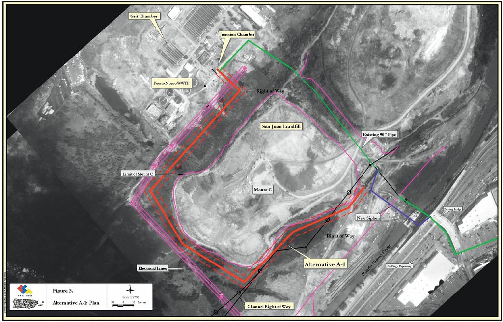
The Question Then Became, Where to Move the Pipe?In early 2000, following initial discussions and the settlement of boundary considerations, PRASA was ready to take corrective action. It turned to the CSA Group (see sidebar), an internationally renowned architecture, engineering, environmental, and construction management firm with an office in San Juan and a wealth of experience in GIS, cartography, GPS, surveying, environmental engineering, feasibility studies, and more. The CSA Group's GIS division, using a combination of Leica Geosystems GPS, surveying systems, and ERDAS IMAGINE geographic imaging software together with ArcView software, provided PRASA with five alternatives for the new pipeline based on comprehensive mapping and analysis of the land use in the area, the expansion of the landfill, the canalization of the Puerto Nuevo River, existing wetlands, and underground gas lines. 16th Century City Thrives in Modern TimesPuerto Rico, supporting a population of close to four million people, is a small rectangle-shaped island, a little more than 3,600 square miles in size. Mountainous terrain breaks into coastal lowlands, culminating in some of the most beautiful and popular beaches of the West Indies.
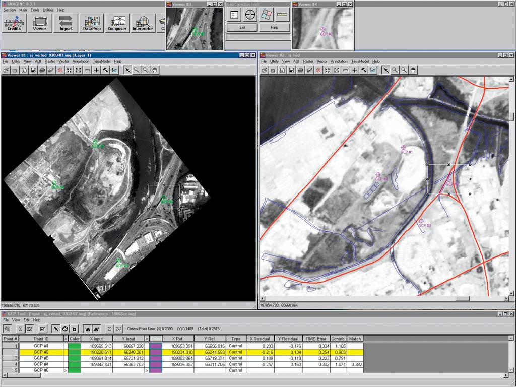
San Juan, the capital of Puerto Rico, is located on the northeastern coast of the island. Supporting a population of 1.6 million, San Juan is a modern city with a bustling commercial center and a historical old town that dates from the early 16th century. Steeped in its centuries-old traditions and history, today San Juan is a major financial center and tourist destination, driving the economy and politics of Puerto Rico, and functions as the cultural epicenter for the United States in the Caribbean. As a commonwealth of the United States, Puerto Rico has a government infrastructure that taps into the rich resources of the U.S. Geological Survey (USGS) and the U.S. Army Corps of Engineers (USCOE), which fortunately has an extensive collection of CAD drawings of the Puerto Nuevo River channel and the water treatment plant. Creating AlternativesThe CAD drawings and other benchmarks from USCOE's Puerto Nuevo River Canalization Project, topographic maps, USGS hydrographic and quad data for the City, and other geographic data from PRASA were useful in establishing a baseline map for the project. Accuracy was critical to avoid right-of-way issues among USCOE, the Municipality of San Juan, and PRASA, and determine cost-effective and environmentally sensitive alternatives. Consequently, new aerial photos and a SPOT satellite image scene (panchromatic with 20-meter [66-foot] resolution) were acquired and new ground control points (GCPs) were collected using the Leica Geosystems SR530, a 12-channel (L1, L2) dual-frequency geodetic-grade survey receiver, and TC305 total station, a positioning and measuring system designed for building and construction environments. Aerial photos collected at 1:10,000 scale were scanned at the same scale, corrected for distortion, and rectified to the CAD-based map with IMAGINE Professional geographic imaging software. The images were then mosaicked into a single 60 MB image file and brought into the ArcView Image Analysis extension for further enhancement and inspection.
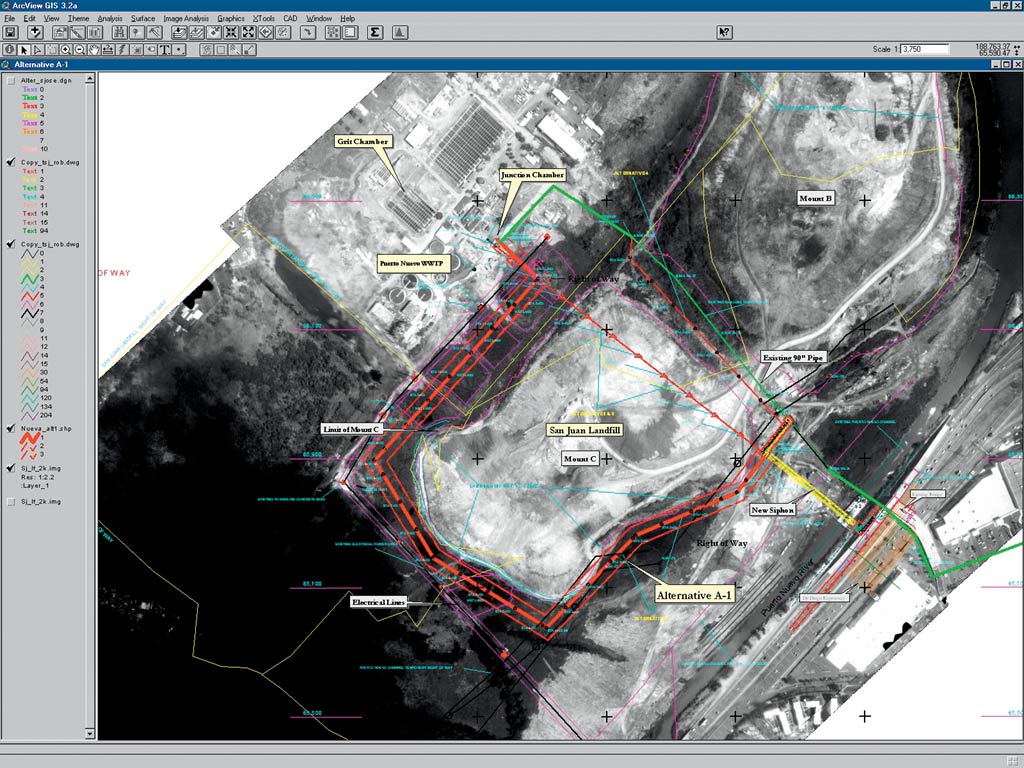
"To our delight, the new imagery-based map derived from the aerial photos, SPOT scene, and new GCPs matched the original CAD drawings perfectly," says Jorge E. Rodriguez, GIS analyst for the CSA Group. While combining surveying data, GPS data, image data, and GIS layers may seem a daunting task for even the most experienced GIS professional, according to Rodriguez. All of the products and their respective formats integrated easily. With the accuracy of the data confirmed, the GIS team quickly analyzed the 300-acre site and the health of the river channel and evaluated different pipeline route alternatives. Using ArcView 3.2a, five possible routes and their axes were identified and subsequently demarcated with stations at 10-meter (33-foot) spacing. Every station was staked out in the field with the SR530 from Leica Geosystems. Then, existing planimetry and topography were mapped within 25 meters (82 feet) of both sides of the axes, and the places where the horizontal alignment of the pipeline could change were surveyed in greater detail. Once the data layers were assembled in ArcView, the five route alternatives were considered in the context of land use, water quality, construction viability, cost, and time. PRASA also required that the solution maintain the hydraulic capacity of the current pipeline and that the construction activities employed to move the pipeline avoid environmental risk related to the landfill and the wetlands in the vicinity. The CSA Group was successful in its mission to define accurately the viable options that met PRASA's criteria. Of the five, two required additional pumping stations and two others would have crossed the landfill, requiring massive excavation and more environmental disruption than the other options. The fifth alternative, and the one that the CSA Group recommended, rerouted the pipe around the landfill, provided enough space for the pipe, offered the least engineering restrictions, and caused the least environmental disturbance. PRASA agreed. The SJTS project allowed the CSA Group to leverage its geospatial toolbox and combine a variety of raster and vector data formats and types to achieve the precision needed to help its client avoid this "catastrophe waiting to happen." For more information about the SJTS project, contact Jorge E. Rodriguez (tel.: 787-754-6800, e-mail: jerodrig@csagroup.com, Web: www.csagroup.com). |