Winter 2005/2006
Winter 2005/2006 |
|||||||
|
|
|||||||
Defining the Components of the Geospatial Workforce—Who Are We? |
|||
|
By Dr. Duane F. Marble, Castlereagh Enterprises, Inc. Currently, we are in the midst of a geospatial labor market shortage that shows every sign of growing more acute in the years to come. The explosive growth in the utilization of geospatial tools and data in nearly every sector of the global economy has been driven by dramatic increases in the capabilities of our tools and in the increased availability of better spatial data. This growth has created a substantial demand for additional, highly qualified personnel in all areas of the geospatial industry. We are in a poor position to satisfy this demand for additional geospatial personnel since we have only a very vague notion of who we are and what—in the aggregate—we are currently doing, let alone what is going to be required in the years to come. This fuzzy situation is reflected in the disarray currently seen in the geospatial activities of the higher education system, both at the community college and university levels. Unlike manufacturing industries where apprentice training is a significant source of workers, higher education has been and still is the primary source of new geospatial workers. Presently, far too many academic programs concentrate on imparting only basic skills in the manipulation of existing GIS software to the near exclusion of problem identification and solving; mastery of analytic geospatial tools; and critical topics in the fields of computer science, mathematics and statistics, and information technology. This state of supply-side disarray is not surprising given that existing academic geospatial programs have been established with little or no feedback from the geospatial industry to assist them in identifying the specific knowledge and skill sets that are required to support particular geospatial activities. The diverse levels of knowledge and skills present in the existing geospatial workforce, coupled with the prospect of a strongly increasing demand for even more knowledgeable and skilled workers, have led to the development of strong concerns in both the geospatial industry and academia about sustaining and improving the quantity and quality of existing and future workforce components. To alleviate these concerns, steps must be taken in the very near future to establish a reliable stream of new entries to the geospatial workforce who are, in general, better qualified than in the past and whose numbers are more in line with developing estimates of the future demand for specific types of geospatial workers. What Are the Perceived Problems with the Geospatial Workforce?The initial problem is that the concept of a "geospatial industry," centered upon a newly identified and rapidly growing and highly technical sector of the economy, has only recently emerged. Something beyond just a "GIS plus" concept, this sector encompasses a broad variety of activities focused upon the acquisition, management, manipulation, analysis, and visualization of spatial and spatio-temporal data. Its recent recognition is based, in large part, upon the rapid growth in geospatial applications that has occurred over the last 15 years in response to substantial developments in the critical primary spatial data acquisition area (GPS, remote sensing, surveying, etc.), geographic information systems, and the development of specialized geospatial analytic and visualization tools. These developments have been closely interwoven with contemporaneous advances in computer science and information technology. At present, the geospatial industry, because of its relative newness, lacks a comprehensive, global view of itself, its activities, and the workforce that supports these activities. Instead, we have a number of overlapping and often myopic views that reflect the views of individual organizations (both public and private) as well as, on the academic side, the traditional approaches of various disciplines. The effective integration of these varying, and only too frequently overlapping, views of what we do and how we go about doing it must represent a high priority. Without such a global view in hand, the difficulty of solving our second major problem—that of identifying specific geospatial workforce components and defining the types and levels of knowledge, skills, and experience each component requires—is substantially increased. The existing geospatial workforce comes from a wide variety of backgrounds. Its heterogeneous character makes it extremely difficult for us to categorize specific components of the workforce in terms of either required or desirable knowledge, skill, and experience levels. Many of the tasks that are undertaken by geospatial workers cut across traditional disciplinary boundaries and require the integration of a number of knowledge and skill components. The geospatial analyst must, for example, be able to understand the manner in which the approach that was adopted to acquire the spatial data being used will impact the analytic results obtained "downstream." Similarly, the individual who is engaged in primary spatial data acquisition activities must be knowledgeable about, and sensitive to, the requirements of the analytical users of the resultant spatial data. The growing importance of geospatial-based activities recently led the U.S. Department of Labor to identify the geospatial industry, together with 13 other sectors, as the focus of its High-Growth Job Training Initiative. The 14 sectors were selected based on the following criteria:
In addition to the geospatial industry, only biotechnology and nanotechnology were identified as being among the most important of these emerging and evolving fields (Gewin 2004). This represents an additional strong mandate to address these major geospatial workforce problems in a comprehensive fashion. Why Do We Need to Know More About the Existing Geospatial Workforce?Identification and categorization of existing geospatial workforce components will make it possible for us to generalize about such things as, for example, the relative demand for a particular type of worker versus the demand for the same type of worker in another part of the geospatial industry. We also would be able to make specific statements about, say, how the necessary entry-level knowledge, skills, and experience differ between different types of geospatial worker (this type of information is, of course, critical to any effective restructuring of academic geospatial curricula). It also would permit more ready evaluation of the prior background and work experience of individuals who are seeking to change positions within the industry. Without an operational, structural model of both the geospatial industry and its workforce, we find ourselves in a weak position from which to address either the geospatial industry's future development or its related future workforce needs. Questions of how the existing geospatial workforce is structured aside, we possess very little information on critical demographic and other attributes of the workforce. These include such things as age, gender, and other differences within the geospatial workforce and the relative importance of foreign workers. Also, since we have a strong interest in things of a spatial nature, the spatial distribution of industry components, geospatial workers, and even users is of considerable interest. What Are the Perceived Problems with the Existing Geospatial Workforce?There is a solution to both our quality and quantity problems, but any such program must be rooted in vitalizing and restructuring the relevant instructional programs in our system of higher education, including not only the colleges and universities but also community colleges. Because of the high level of technology encountered in the sector and the continuing rapid changes that are expected to occur in this technology, any such activity must also explicitly address the availability of continuing, in-service professional and technical education for the existing members of the geospatial workforce. Such educational programs will require the coordinated efforts of academia, industry, and government, applied over a significant period of time, to attain the needed results. But what do we mean when we identify a need for "better-qualified" persons in the geospatial workforce? Questions that have been repeatedly raised in this context have focused on two broad concerns. The first of these is a declining depth of both conceptual knowledge and practical skills in the area of computer science/information technology among those individuals currently entering the geospatial workforce. For example, the potential utility of the modern GIS extends far beyond what is provided by the icons available on the default screen display. But this potential is likely to remain unrealized if the individual user of geospatial technology has only a minimal conceptual and operational knowledge of such things as databases, system design approaches, and the role of the operating system or is unable to respond to the notion of reconfiguring the available object modules with a bit of programming. While there is perhaps, in theory, a role for a limited number of "crank turners" in the geospatial industry, it would seem to be one area where the demand is very limited.
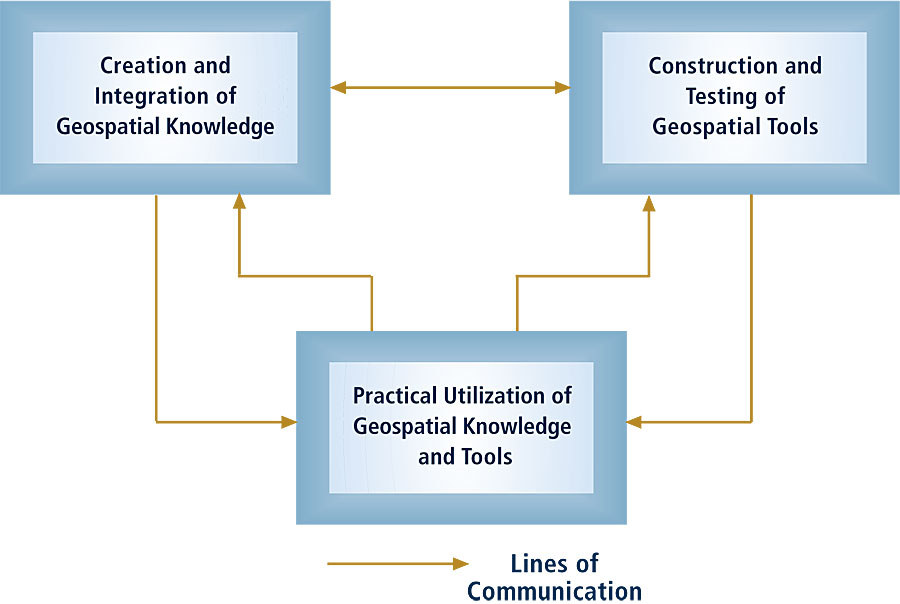
The second major concern is one of breadth rather than depth and arises out of the broad scope of geospatial activities and their generally high level of interdependence. As pointed out in an earlier example, the geospatial analyst and the collector of geospatial data cannot effectively operate in ignorance of what each other is attempting to accomplish and what limitations restrict their respective activities. In much the same way, those whose primary concern lies in the use of geospatial data and tools in problem solving must have an operational understanding of what can and what cannot be accomplished within the context of current geospatial capabilities. Certainly, no one individual can become a specialist in all of the many technical areas that contribute to the geospatial industry, but there is a significant need for a broader basic understanding of these among all workers in the geospatial industry. While difficult to accomplish, given existing educational approaches, the development of a "basic core" of common knowledge that is shared among all members of the geospatial workforce is a highly desirable goal. Given the substantial gap that exists between what we are currently capable of doing in the geospatial realm and what we anticipate we will need to do in the near future, it is certain that the substantial pace of scientific and technical development within the geospatial industry will not only continue but will most likely accelerate substantially in the years to come. Those individuals who make up the geospatial workforce must be capable of dealing with a continuing pattern of rapid change, as well as with the substantial challenge of adapting existing knowledge and tools to uses in a variety of new, complex situations. Thus, flexibility, spatial problem identification and solving capabilities, and an above-average knowledge of computer and information science, as well as the ability to spend their careers in a near continuous learning mode, become critical characteristics at nearly all levels of the future geospatial workforce. Addressing Our Geospatial Workforce ProblemIdentifying that significant problems exist with respect to the geospatial workforce and establishing general goals for their resolution are certainly necessary steps, but before moving on to define potential operational solutions, we must have a clear notion of where it is we are going. Our present situation is made more complex since nearly all of what we currently know about the geospatial industry and its workforce components is basically anecdotal in nature. This brings to mind the classic tale of the blind men and the elephant and raises, in turn, a difficult question: how are we to determine the path (or paths) that will take us to our desired destination if we are not sure of where we are starting from? In attempting to approach any operational solution, it is apparent that a major difficulty arises from our lack of a well-defined notion of the overall scope of the geospatial industry and its associated workforce. As an initial step, we need to agree upon a detailed geospatial industry domain description that is accepted by a majority of the interested parties. Lacking this common global definition, it becomes difficult to identify, let alone focus effectively upon, specific components of the geospatial workforce. Such a detailed domain definition permits us when dealing with a specific organization (private or public) to be able to classify that organization as being, in terms of its activities, either fully or partially involved with the geospatial industry. And, of course, we must be able to make similar decisions with respect to the components of that organization's workforce. Is Esri part of the geospatial industry? Is Jack Dangermond part of the geospatial workforce? What about the people working in the Esri Shipping Department? And what about all those who make up the ever-growing geospatial user community? Examining a large organization that has several thousand employees, we might identify, say, a GIS department of 25 persons that is serving an internal user community of perhaps 400. Do we include the GIS staff members and exclude the 400 direct users? Do we include the 400 users and exclude the thousands of other employees? Without clear definitions, we are free to do almost anything that we want but then no two assessments will ever agree, and our knowledge of the geospatial industry will be as cloudy as ever. In developing working definitions of the scope of both the geospatial industry and its workforce, I would suggest that we recognize at the start the need to distinguish between (a) workers whose primary concern lies in the area of relevant knowledge generation and integration activities, (b) workers whose primary concern is with problems of tool development and testing, and (c) workers whose concern is primarily focused on the practical utilization of knowledge and tools. The latter area could, if desired, be easily subdivided into activities associated with the primary acquisition, storage, and management of spatial data on the one hand and those who are focused on problem identification and resolution on the other. These three (or four if you choose) general areas not only generate specialized demands for workers with particular sets of skills and experience levels, but during periods of rapid technological change, workers in these areas need to be closely linked to each other by strong communication channels supporting technical interaction. Figure 1 illustrates this suggested structural view. Continued on page 2 |