Winter 2006/2007
Winter 2006/2007 |
|||||||
|
|
|||||||
Los Angeles Fire Department Gets Better Information for Tactical Decisions with GIS
Firefighter Inspires New Mapping System to Help Assess Risks, Map Fires, and Allocate Resources |
|||||
|
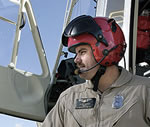
Necessity can truly be the catalyst for innovation. For Los Angeles, California, firefighter Steven Robinson, it was the need—or desire—to stay an active member of the Los Angeles Fire Department's Air Operations Unit that ultimately led to his developing an advanced GIS mapping and emergency response system. In March 1998, Robinson was involved in a terrible helicopter accident caused by a broken tail rotor that killed three rescuers and the patient they were transporting to the hospital. Only Robinson and one of the helicopter crew members survived the crash. He spent two years undergoing rehabilitation to regain his ability to fly as a pilot. Then a seizure in 2001 due to head injuries from the crash left him medically unable to fly. Relegated to nonpilot status, Robinson found himself looking at the possibility of no longer being a member of an air unit he had spent years preparing to join. "I wanted to remain an active member of my unit, and I wasn't sure how I was going to make that work," says Robinson, who served as a helicopter pilot III. "I didn't want to leave. I spent years in flight training and nearly $60,000 to get into the unit, and after the accident I didn't want to give that up." Necessity Turns to Good FortuneRobinson still worked in his Los Angeles Fire Department unit to help with video downlink, thermal imaging, and helitac training. He began working with a new computer on one of the fire department's helicopters. The computer provided basic GPS functionality used to help navigate the aircraft. The more he worked with the computer, the more he became comfortable with the technology. He recognized the potential value of digitally locating things that were on the ground using computers from the air. About this time, in his words, he "had an epiphany of sorts" and contacted Esri staff, who then worked with him to create a custom mapping system to gather large and diverse datasets to support incident commanders in developing situational awareness, determining incident status, and assigning fire equipment to appropriate locations of the incident. Real-World Test
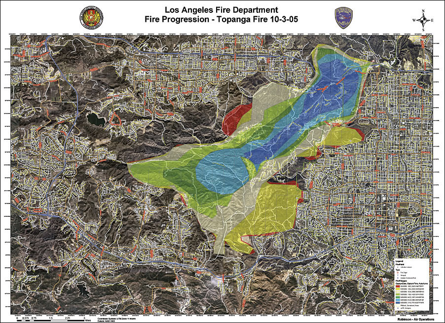
Robinson's newly developed mapping system got its first big test during the Simi Valley fire in 2003. The fire was destroying thousands of acres of land, and the Los Angeles Fire Department needed the most accurate fire perimeter maps available, giving Robinson a chance to use the system in a real-world scenario. Robinson and pilot Lance Messner jumped into a helicopter, flew to the fire, mapped it, and georeferenced the fire to topography. Robinson used the onboard GPS system to map the fire perimeter and created a GIS shapefile. This shapefile was then imported into ArcGIS and integrated with other existing data layers, including vegetation, streets, topography, and housing developments. At the Air Operations Unit office in Van Nuys, California, this data was then used to print a large, high-quality cartographic map that illustrated the fire perimeter and its proximity to homes, streets, and the type of vegetation currently burning and ahead of the fire. This map was then sent to a forward command post near the fire for use by chief officers and other command personnel. During this emergency, Robinson and Messner were contacted by the United States Department of Defense (DoD), which had learned about the mapping process from the Air Operations Unit and wanted to stream the information to Washington, D.C. A team was mobilized to help Robinson set up computer mapping links with the goal of sending the data to Washington, D.C., emergency command headquarters. DoD staff arrived to provide satellite imagery, high-speed networks, and other integration support services to enhance Robinson's GIS capabilities. These helped establish a more powerful map server database and a real-time information feed so that newly generated maps could be used by both local responders and national commanders. ArcIMS and ArcSDE were used to store and manage the GIS data for the Hewlett-Packard (HP) server. This gave Robinson the capability to publish all the work done in ArcGIS (incident analysis, incident spread predictions, etc.) to the Web using ArcIMS for other personnel and Los Angeles City departments to have access to important maps and incident information. "We were able to publish and show topographic maps of mountainous terrains, neighborhoods, houses, closed and available roadways, and vegetation density in a way that would not be possible without the system," says Robinson. The system again proved its merit during the 2005 Southern California Topanga fire. The blaze destroyed 24,000 acres of land, yet no fatalities resulted and only a few homes were lost. Again, GIS and GPS were used to map fire perimeters by the hour. Calculations were performed to measure the forward spread of the fire based on the terrain vegetation and weather. These calculations were then used to predict where the fire would progress over the next several hours. Robinson told commanders the fire would reach a vital freeway pass, then progress to residential neighborhoods, hours earlier than they originally anticipated. With this new knowledge in hand, proper resources were redeployed to stop the fire's path of destruction. Incident commanders used the new GIS fire projection data to successfully aid in evacuating neighborhoods in the fire's path. Damage was kept to a minimum. GIS Use ExpandsOnce it was introduced by Robinson, the system has been drawn upon time and again for other events. It has also proved valuable for the 2006 Academy Awards, 2006 Grammy Awards, and other events where multiple agencies needed to have a common operating picture. Robinson has also begun work with other departments, such as the Beverly Hills Fire Department, so that these capabilities can be harnessed by other local agencies. GIS use has expanded throughout the Los Angeles Fire Department. During a recent homeland security exercise in Los Angeles, known as Operation Determined Promise, ArcIMS was used to provide highly secure Internet mapping to first responders and incident commanders, as well as fire, public health, law enforcement, and other participating agencies. Currently, the GIS helps provide near real-time computer mapping and data visualization in response to all types of incidents. Maps are distributed via the Web using ArcIMS and used for planning purposes. Data such as wind, temperature, and humidity can be combined with incident data; demographic information; and city parcel, building, and satellite imagery for a complete picture. ArcGIS Desktop software is used by the department to analyze all the variables necessary to predict the size and direction of plumes from chemical spills; show earthquake-damaged buildings and roadways; and set up medical perimeters in the event of a spread of an infectious disease, such as smallpox. These analyses are performed using two extensions to ArcGIS—HAZUS (developed by FEMA) and the consequence assessment tool set (produced by SAIC and the Defense Threat Reduction Agency). More InformationFor more information, contact Steven Robinson, helicopter pilot III, Los Angeles Fire Department (e-mail: steven.robinson@lacity.org). |
 This article is part of an ongoing series honoring individuals who have made a difference in the world by applying a GIS solution to challenges or needs within conservation or their communities. Since these unique individuals have been selected for their innovations or special achievements in a particular field, the series is appropriately named GIS Heroes. Esri recognizes Steven Robinson of the Los Angeles, California, Fire Department as a GIS hero.