ArcNews Online


    WINTER 2006/2007   COVER STORIES   T-SHIRTS WORLDWIDE
 
 
Winter 2006/2007 ArcNews cover, click to see enlargement

Now with exclusive online-only articles.

Previous Issues
Fall 2006
Summer 2006
Spring 2006
Winter 2005/2006


ArcGIS Online Services Introduced: Ready-to-Use Content for ArcGIS Users


Nature, the Human Network, and the Role of GIS


GIS Is Providing a New Medium for Understanding: Geography and GIS—Communicating Our World
  GIS and Society


GIS Powers Electric Industry: Energy Companies Worldwide Benefit from GIS
  Power Cooperatives and Municipals in U.S. Are Better Equipped with GIS
  Worldwide, GIS Transforms Electric Utilities


Exploration in the Age of Digital Earth


DHS Selects Esri for GIS Enterprise: Streamlines Access to GIS Software


As GIS Continues to Evolve, Esri Grows with the Flow: Esri Recaps a Year of Meeting Its Users' Needs


China, New Zealand, Florida—Travel Is Good... Especially with Your Esri T-Shirts!

T-shirt Photos from Previous Issues
some previous t-shirt photos; click to see latest issue photos


    GIS PRODUCT NEWS   GIS IN THREE DIMENSIONS   GIS COMMUNITY NEWS
 
 
ArcGIS Explorer—New Tool to Access Mapping and Geoprocessing Services

The Changing Face of the United States of America: Esri Demographic Update Methodology: 2006/2011 White Paper

Introducing ArcGIS for AutoCAD: Leveraging ArcGIS Server Capabilities from Within the AutoCAD Application

ArcGIS Image Server 9.2 Redefines Dynamic Imagery Distribution: New Server Product Is Now Shipping

ArcReader 9.2 Includes Enhanced Map Viewing and Printing Capabilities: Download Available for Linux, Solaris, and Windows Platforms

ArcGIS Defense Solutions 9.2 Now Available: ArcGIS Military Analyst and MOLE Help Defense Planners

 
  GIS IN ACTION
 
Carbon Dioxide Sequestration Communications Supported by GIS: A Study of the Great Plains of North America

|Online Only Article|
Al Gore Heats Up a New Kind of Campaign: Former Vice President Says Environmental Sustainability Promises Many Profits

Student Interns Partner with City to Launch Groundbreaking GIS Project: Dearborn, Michigan, Discovers That Geography Is the Common Thread

Finding, Reaching Service Centers: Credit Union Service Corporation Routes Customers with GIS

Esri Business Partners Offer Products and Services for Users: Providing Data, Software, and Services Solutions

Bridging Spatial and Nonspatial Data: GIS at the North Carolina Department of Transportation

Web-Based Asset Management: GIS Helps Track Public Works Projects in Indianapolis, Indiana

Spreading Data Improves Crop Yield: New Zealand Fertilizer Application System Uses GIS/GPS

Exclusive ArcNews Online Articles


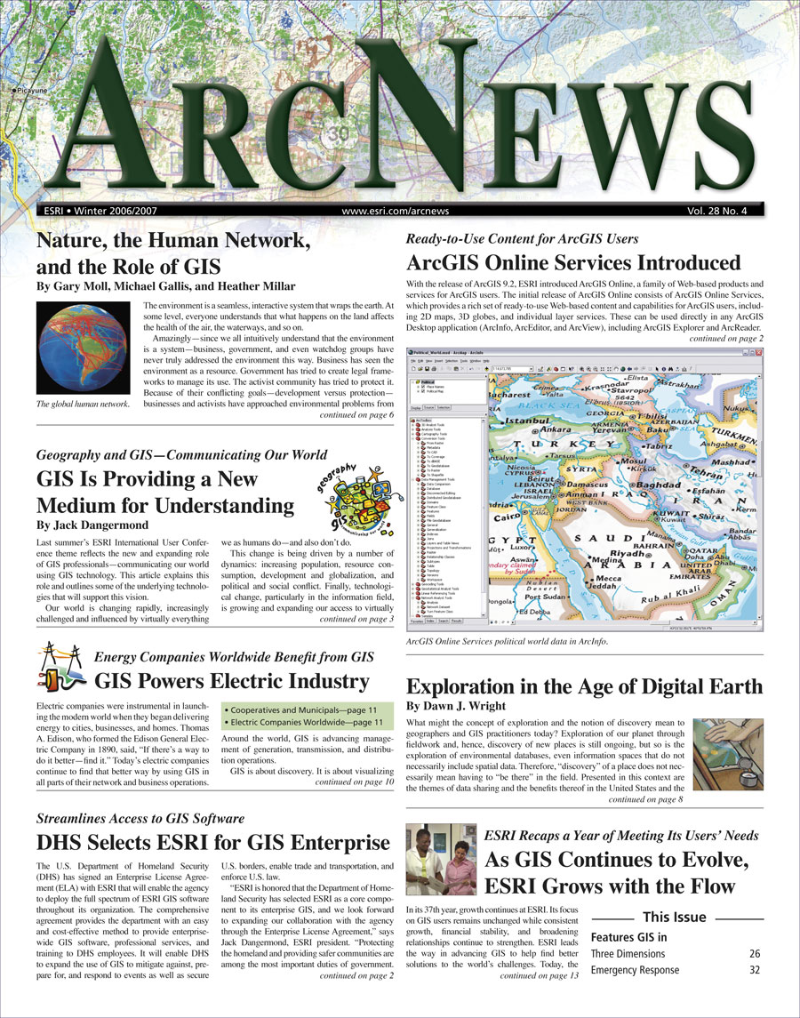
Immersive Visualization System Promotes Sense of Being There: Using GIS, West Virginia University Provides New Tool for Researchers and Analysts

Minimizing Avian Mortality in Siting Wind Turbines: GIS Helps Determine and Forecast Causal Correlations

The ArcGIS Format for Representing Three-Dimensional Objects: Multipatch Geometry

Supporting Island Land Conservation: Conservation Trust of Puerto Rico Finds GIS to Be the Ideal Tool

Maintaining Accurate Data During Brownfield Site Redevelopment Excavation: The City of Milwaukee, Wisconsin, Manages a Remedial Excavation with GIS

Defining Soil Remediation Scope and Budget: Decommissioned Army Ammunition Plant Modeled with GIS

 
  EMERGENCY RESPONSE GIS
 
GIS Hero
Firefighter Inspires New Mapping System to Help Assess Risks, Map Fires, and Allocate Resources: Los Angeles Fire Department Gets Better Information for Tactical Decisions with GIS

GIS Enables Ground-breaking E911 Application at Maui Police Department: First Hawaii County to Provide Wireless Phone Emergency Location

Identifying Helicopter Landing Zones in Wake of Hurricane Katrina: U.S. Army Develops Critical Map Using GIS

GIS Technology Builds a Common Language for Emergency Preparedness: Homeland Security GIS Summit Focuses on Information Sharing

Providing In-Vehicle Access to More than 3,500 Prefire Plans: Milford, Connecticut, Fire Department Uses GIS for Optimizing Incident Response

Maximizing Time, Resources, and Money with Real-Time Vehicle Tracking and Intelligent Routing: Pinellas County, Florida, Implements Cutting-Edge GIS Solution for Emergency Medical Services

Revisiting the Esri Map Book Vol. 21: Estimating a Disaster


Esri Hosts Its 2007 International User Conference June 18-22, 2007: Largest Gathering of GIS Professionals Brings Collaboration Opportunities to All Levels of GIS Users
  Public Works SIG Launching: First Meeting to Be Held at Esri International UC

Managing GIS
Enterprise GIS—Some Keys to Success

Crossing Borders
The International Geographical Union: New Roles and Relevance

GIS Day Brings New Dimension in Geography to Communities Worldwide

Ninth Annual Middle East and North Africa Conference for Esri Users

2007 URISA Conferences

Charting the Unknown: How Computer Mapping at Harvard Became GIS: Esri Press Book Delves into the Beginning of GIS

Free Esri Publications

|Online Only Article|
Esri Northeast Africa Established

Increase Your GIS Software Development Skills at the Esri Developer Summit

21st Annual European Conference for Esri Users Held in Athens

Thirteenth Annual Latin American Conference for Esri Users

Esri Launches One-Stop Training and Education Web Site

Smart Land-Use Analysis: The LUCIS Model: New Esri Press Book Maps Techniques to Analyze Land Use

Agencies Use Server Technology for Web Mapping

GIS Greatest Hits: New, Free Booklets Present Collected Resources

Listen to Esri Podcasts

Esri Training and Education News

Career Opportunities at Esri


Contact Us | Privacy | Legal | Site Map