Winter 2006/2007
Winter 2006/2007 |
|||||||
|
|
|||||||
First Hawaii County to Provide Wireless Phone Emergency Location
GIS Enables Groundbreaking E911 Application at Maui Police Department |
|||||||
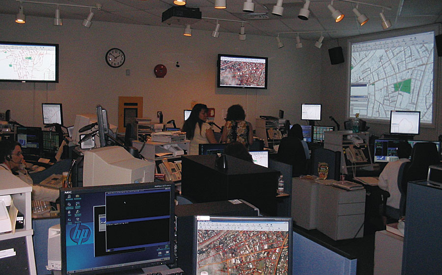
An emergency call from a cellular phone comes in to a police dispatcher. The caller, from out of state, has accidentally veered his car off the road and crashed in a remote area not frequented by vehicles. He is disoriented, perhaps injured, and doesn't see any street names. No other cars or witnesses are around. The caller needs help but can't tell where he is and has no way of telling the dispatcher how to find him. This is the kind of scenario currently facing many law enforcement and emergency response agencies like the County of Maui, Hawaii. How do you locate an emergency call in an isolated or remote region from a wireless caller with no specific location information? To respond to U.S. federal government mandates, as well as look for ways to better serve both its residents and the many visitors who frequent the area, the Maui Police Department (MPD) has improved its ability to locate emergency calls from cell phones. The MPD and county GIS staff have put in place a GIS-based E911 system that locates wireless calls when they come in and provides staff with the means to act appropriately. The system puts MPD among the first to meet new federal requirements mandating mobile locations for E911 calls.
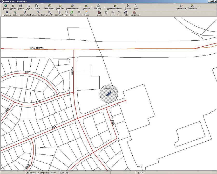
"The department needed to meet the federal mandate to provide accurate locations for E911 calls from cell phones," says Tommy Takeshita, dispatch supervisor, Maui Police Department. "We already had in place an accurate system for pinpointing telephone calls from landline locations. Cell phones present a unique challenge because they are wireless and mobile and not tied to a specific location or address. We needed to be able to locate and plot calls from these devices dynamically based on an x,y coordinate. The only way to do this is with GIS." The MPD GIS-based E911 dispatch system lets emergency dispatchers track the locations of people using a wireless phone to call in an emergency. The system can pinpoint and digitally map an emergency call location within seconds, allowing dispatchers to rapidly respond to emergencies no matter the location. The system is the first to go online for the state of Hawaii. Meeting the Ever-Increasing Demands of Public SafetyIn response to the federal Wireless Communications and Public Safety Act of 1999, MPD initiated a pilot project in cooperation with County of Maui GIS staff to provide a proof-of-concept prototype with location capabilities for wireless calls. This prototype was demonstrated in Hawaii and at several conferences on the mainland, and the application and datasets were refined based on the input from these demonstrations. By moving forward with the technical development of the system while the formal enabling legislation and fee structure were adopted, MPD was able to achieve full deployment of the wireless E911 system less than one year after the impanelment of the State Wireless Enhanced 911 Board. The system meets Federal Communications Commission Phase I and Phase II requirements for locating wireless E911 calls within 300 meters. Approximately 9,000 emergency E911 calls are made monthly in the county. Of these, roughly 50 percent are made from wireless telephones. There are 3,142 counties in the United States, but fewer than 400 currently have the capabilities the County of Maui possesses today.
MPD deploys ArcView and ArcInfo software. The Positron PowerMap application from Public Safety Systems, Inc. (Lanham, Maryland), provides automatic display and management of calls, incidents, responses, and resources. Street data is maintained by MPD, with the county supplying parcel and other spatial data layers. MPD also uses additional spatial data layers, such as police beats, fire engine company districts, ambulance service areas, lifeguard areas, and more, for added response and analysis capabilities. "We are saving lives and making our community safer for our residents and visitors," says Bill Medeiros, GIS manager, County of Maui. "We are not a large county, yet we were able to do the initial prototype in-house and at very little cost to the taxpayers. Doing the prototype in-house also gave us the knowledge to better review the various applications on the market. The prototype set the bar in terms of minimum acceptable standards, and MPD refused to use any system that did not meet or exceed that standard." The GIS provides an invaluable service for the county. The ability to locate wireless callers who may be on the beach, hiking off road, or camping at a remote site gives police and others the ability to help those in need who might be hard to locate otherwise. The county, like much of the state, is frequented by out-of-state vacationers who may not be familiar with street names and landmarks. Moreover, Maui is a multi-island county and includes the islands of Maui, Molokai, Lanai, and Kahoolawe. Calls may originate from any of these islands or in the ocean that surrounds the islands. In one real-life example, a tourist placed an E911 call from a beach where the person could see swimmers snorkeling in the ocean who were in need of emergency assistance. The caller was unable to provide an address or location. Within seconds, police dispatchers were able to quickly pinpoint where the caller was and respond accordingly. In addition to the E911 system, MPD uses ArcGIS for a number of crime analysis and preplanning activities, including classifying crimes by geographic area, date, and time; performing visual incident analysis; and using GIS for event coordination and modeling and tactical and strategic planning. The MPD GIS is a result of government collaboration and leveraging existing GIS resources, such as county parcel data. Seven County of Maui departments use GIS data and applications. In addition, the county GIS division provides GIS mapping and analysis services and products to another six departments or offices within the county. The cross-coordination and data sharing result in more effective government operations and cost savings. More InformationFor more information, contact Bill Medeiros, GIS manager, County of Maui, Hawaii (e-mail: mauigis@maui.net). |