Winter 2006/2007
Winter 2006/2007 |
|||||||
|
|
|||||||
Using GIS, West Virginia University Provides New Tool for Researchers and Analysts
Immersive Visualization System Promotes Sense of "Being There" |
|||
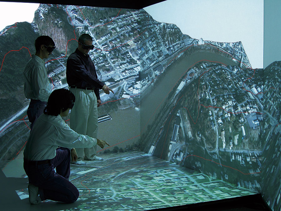
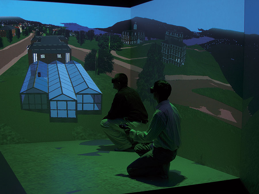
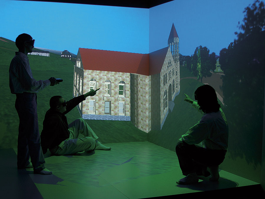
Geovisualization has always been critical to GIS. The focus on digital maps as the mainstay of cartographic representation has, of course, now been extended considerably to include contemporary Web-based mapping technologies, which are predominantly two dimensional. Now multidimensional geobrowsers, including ArcGIS 3D Analyst software's ArcScene and ArcGlobe applications, present the data in a form that assists users in the interpretation of the available information in a more intuitive and innovative manner. Simultaneously, the browsers offer interactive and dynamic navigation tools that greatly facilitate rapid data exploration. These trends have been augmented through initiatives led by Dr. Trevor Harris and D. Vic Baker in the Department of Geology and Geography at West Virginia University (WVU) by the addition of state-of-the-art immersive technologies and the coupling of GIS with these powerful visualization technologies. In August 2006, the GeoVirtual Laboratory (GVL), housed within the Department of Geology and Geography at WVU, working with Mechdyne Corporation (Marshalltown, Iowa) subsidiaries Fakespace Systems Inc. (Marshalltown, Iowa) and Esri Business Partner VRCO Inc. (Virginia Beach, Virginia), completed the installation of a four-wall stereoscopic immersive visualization system. Called the FLEX VR system, this is a room-sized interface consisting of rear-projected front, left, and right walls and a ceiling-mounted floor projection. The FLEX VR system (commonly referred to as a CAVE) utilizes head tracking and orientation sensors, as well as shutter glasses that work in tandem with the stereoscopic projection system and cluster computing to provide the user with total visual immersion. The FLEX VR system is the world's first commercial, reconfigurable visualization solution for users whose viewing, collaboration, and presentation requirements could not be met within the confines of a single, fixed visualization environment. Its innovative hinged wall design Now with ArcGIS 9.2, ArcGIS Explorer, and ArcGIS Server, integration of immersive visualization is evolving to allow for better and more rapid spatial analysis and interpretation within a collaborative virtual environment. Researchers at WVU are now taking full advantage of the advanced immersive and interactive display capabilities provided within the system. Proprietary spatial software has been written to work within the FLEX VR system, yet having access to Esri's commercially available software enables rapid development of GIS visualization content. Furthermore, users across the WVU campus are able to generate content without the need for direct access to the system. Interaction with the spatial data in the immersive environment is very intuitive. A wireless motion-tracking system monitors the user's position and changes the on-screen images in real time to maintain proper viewing perspective. Navigation through the data scene is accomplished effortlessly using a wireless, handheld virtual wand. The team is currently exploring new research areas using the FLEX in a variety of topics, such as forensics, low vision, historical and archaeological reconstructions, architectural The vision of the GeoVirtual Laboratory is to pursue research that draws extensively upon the tight coupling of the spatial analytic capabilities of GIS with the powerful visual and immersive capabilities provided through the FLEX display system. The unique experiential nature of the immersive display system and the feeling of "being there" and immersed in the data scene provide powerful insights into complex spatial data and landscape forms. Examining the viewsheds and potential visual intrusion of cell towers or electrical transmission lines becomes so much more powerful when explored by users immersed in the virtual landscape and able to navigate freely through the landscape as if in a helicopter. Similarly, re-creating historic landscapes and historic urban centers using a combination of historic maps and photographic evidence is relatively easily achieved and displayed in the FLEX such that users may immerse themselves in the three-dimensional scene and interactively access data through the GIS interface. Such capabilities are a long way from the traditional two-dimensional map. Furthermore, the immersive space supports multiple users simultaneously and provides a powerful collaborative decision-making environment that is immersive, dynamic, and interactive and a long way from the single screen display of most GIS users. Utilizing commercial off-the-shelf applications with advanced visualization displays, it is possible to shift time and focus from the development of proprietary applications to the creation of rich content, dynamic interaction, and a powerful interpretive environment. More InformationFor more information, contact Trevor Harris, chair, Department of Geology and Geography, West Virginia University (e-mail: trevor.harris@mail.wvu.edu), or Vic Baker, director, GeoVirtual Laboratory, Department of Geology and Geography, West Virginia University (e-mail: vic.baker@mail.wvu.edu). |