Winter 2006/2007
Winter 2006/2007 |
|||||||
|
|
|||||||
Conservation Trust of Puerto Rico Finds GIS to Be the Ideal Tool
Supporting Island Land Conservation |
|||
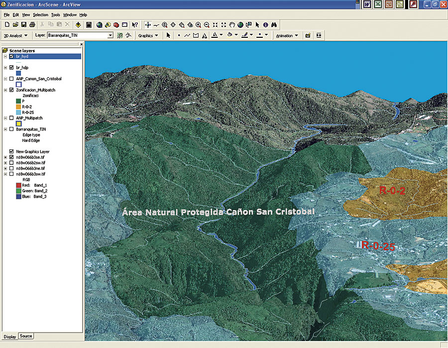
As a result of rapid urban sprawl and the depletion of natural resources on the island of Puerto Rico, the government of Puerto Rico and the U.S. Department of the Interior created the Conservation Trust of Puerto Rico in 1970. The trust is a nonprofit institution devoted to the acquisition and protection of ecologically important lands in Puerto Rico and the development and promotion of environmental, educational, and research activities in natural protected areas. Today, the trust owns and manages about 19,000 acres of important natural habitats of many species of flora and fauna, including critical habitats for threatened and endangered species; conserves historically important landscapes and man-made structures; and protects unique natural and historical landscapes. After recognizing the need to effectively manage its geographic information, the trust decided to establish, in July 2003, the Conservation Trust's GIS Unit (CTGISU). In essence, CTGISU has the purpose of creating, managing, and updating the GIS data concerning the existing and potential natural protected areas and projects of the trust. The core of CTGISU is ArcView software. The first task of CTGISU was to determine the location of all natural protected areas managed by the trust in a geographic database. For this purpose, the coordinate information from the land surveys of all properties was plotted in the ArcView interface as x,y events in the cases where the coordinate system was known. When arbitrary geographic coordinates were used, the polygons were drawn with an unknown coordinate system and georeferenced using the ArcGIS Spatial Analyst extension. To accomplish this task, high-resolution IKONOS satellite imagery for Puerto Rico was used as a background, and referencing image and recorded GPS data from identifiable land parcel limits was used to make the polygon adjustment. As a result, the trust managed to accurately locate more than 40 land parcels that constitute the 19 natural protected areas owned by the trust. CTGISU used GIS, including the ArcGIS 3D Analyst extension, as a tool to assist in the decision-making processes that involve the evaluation of land parcels offered to the trust by private landowners. Life zones, vegetation cover, critical habitats, biodiversity, and potential expansion are, among others, important criteria evaluated by the trust to establish and validate the interest in acquiring a particular portion of land. All these criteria are displayed as GIS layers in ArcView, then overlaid along with the boundaries of a property to determine if the property is important in terms of at least one of the criteria mentioned above. After creating the information regarding land stewardship, CTGISU began the process of generating the GIS data for managing the properties, for example, the delineation of trails and locations of critical species, restoration sites, and discernible landmarks like cave entrances. CTGISU also located areas of existing and potential conflict, such as proposed development, dwellers, and sources of contamination. All this information was generated using the Leica GS-20 GPS system. Land features discernible from the IKONOS satellite imagery were digitized on screen. Answering QuestionsGIS has also proved to be an ideal tool for creating comprehensible maps that fulfill the educational needs of the trust. For example, several maps created with ArcView have been published in periodicals and publications of the trust, for example, La Naturaleza de la Isla de Vieques: 100 Milliones de A�os de Historia (The Nature of the Island of Vieques: 100 Million Years of History), a publication that describes the natural history of one of Puerto Rico's island-municipalities. and 100 x 35, a periodical for the general public that educates about the environmental issues of the island. With these ArcGIS technologies available, the trust has been able to, for example, generate 3D visualizations of its properties and adjacent land parcels with proposed construction projects. These visualizations have effectively supported the protection and defense strategies against the impact of proposed developments in the neighboring lands of a natural reserve. More InformationFor more information, contact Joel Mercado, GIS specialist, Conservation Trust of Puerto Rico (tel.: 787-722-5834, e-mail: mercadoj@fideicomiso.org). |