Winter 2006/2007
Winter 2006/2007 |
|||||||
|
|
|||||||
Multipatch Geometry
The ArcGIS Format for Representing Three-Dimensional Objects |
|||||
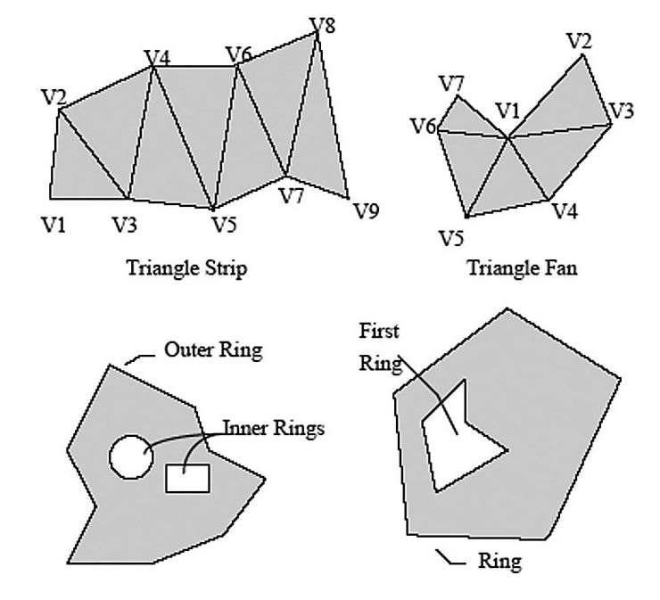
A GIS can represent features in more than two dimensions. Using the ArcGIS 3D Analyst extension, functional surfaces can be displayed in two-and-a-half dimensions (2.5D) and features can be rendered as objects with surfaces in space in three dimensions (3D). This adds perspective to the visualization capabilities of GIS. The term 3D is widely misused. Many software applications today actually store and display data only in 2.5D. ArcGIS has the ability to work with both 2.5D and true 3D data. ArcGIS 3D Analyst can store 2.5D functional surfaces, such as raster, triangulated irregular network (TIN), and terrain data. A functional surface is continuous, and all surface locations may have only one elevation, or z, value per x,y coordinate. True 3D surfaces are sometimes known as solid model surfaces, and ArcGIS handles these through multipatch features. Multipatches are a type of geometry composed of planar three-dimensional rings and triangles, used in combination to model objects that occupy discrete areas or volumes in three-dimensional space. Multipatches may represent geometric objects, like spheres and cubes, or real-world objects, like buildings and trees. For example, a telephone pole could be represented as a multipatch object. There is a z-value at the top of the pole and a different z-value at the bottom. However, if one wanted to measure all the foot-rungs on the telephone pole, the result would be one telephone pole in x,y space, with many z-values, each one representing another rung on the way up the pole. Solid models are common in CAD, engineering, and other applications representing solid objects. ArcGIS can render 3D models as features in a multipatch feature class. Other examples of objects suited to solid modeling are machine parts, highway structures, buildings, and other objects placed on the earth's surface.
Multipatch data is stored in the geodatabase or shapefiles in the same manner as point, line, and polygon data. It can have attributes and can be used with the standard tools, such as the Identify tool. However, its geometry type is unique to ArcGIS in that it can contain 3D models with vertical and overhanging faces. These faces may contain texture information, such as a digital photograph of the front of a building, allowing the creation of photorealistic 3D views. Displaying multipatch data is, for the most part, the same process as displaying other geometry types. However, given its additional capabilities, there are many optimization techniques for multipatch data that users should be aware of when consuming it. For more information about this, consult the online ArcGIS help. Multipatch geometries can also be stored as an ArcGIS ArcMap style and used to symbolize point features. ArcGIS 3D Analyst works with 3D objects created in other software programs. Models created using OpenFlight 15.8 (.flt), SketchUp 5.0 (.skp), 3ds max (.3ds), or VRML 2.0 (.wrl) can be exported in multipatch format and imported into ArcGIS 3D Analyst as symbols. They can be imported when symbolizing a feature, or they can be imported into a style. One use of this is to symbolize point features as trees or light poles within a 3D view. Yet another way of consuming multipatches in a 3D view is to add them as 3D graphics into the ArcGlobe or ArcScene applications within ArcGIS 3D Analyst. These 3D models are saved with the current 3D document rather than as features in a database. Text and other graphics, such as points, lines, and polygons, can be added to a view to bring attention to certain features or emphasize important areas. For example, a study area could be defined by enclosing it with a line or polygon boundary, or buildings can be labeled. Add realism to the 3D view by placing trees, cars, and light poles as multipatch graphics at key locations. Many edit actions are useful for multipatch geometries and are available for use with multipatch features. In summary, ArcGIS supports both 2D and true 3D data types in the form of functional surfaces and multipatches and can readily use objects created in other 3D modeling software packages. More InformationFor more information, visit www.esri.com/3danalyst. |