Winter 2006/2007
Winter 2006/2007 |
|||||||
|
|
|||||||
GIS Helps Track Public Works Projects in Indianapolis, Indiana
Web-Based Asset Management |
|||
|
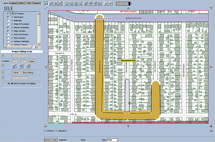
By Jeff Albee and Brad Christensen, AMEC Earth & Environmental The Indianapolis, Indiana, Department of Public Works oversees maintenance and construction of the city's infrastructure, including streets, sewers, bridges, levees, sidewalks, and traffic systems. To better manage projects that involve these assets, the department developed a Web-based GIS tracking system that has helped it maintain an ambitious schedule of capital improvement projects during a period of rapid growth.
Prior to this implementation, the department tracked projects in a tabular database without any graphic representation of the project area. With the tabular system, the department faced several challenges that clearly made the Web-based GIS necessary for improved efficiency and productivity. One challenge was ensuring that conflicting projects were not scheduled in overlapping areas (e.g., a road resurfacing project being followed by sewer maintenance that required the road surface to be removed). Without visual representations of the project areas, these conflicts were not always apparent. Also, when staff input data into the system, there was a lag between the input time and the time the change was reflected in the system. Additionally, there was a strain on the department since it had to produce each map independently. Following intensive evaluation, the department selected a new Web-based system, developed by international engineering company AMEC Earth & Environmental, an Esri Business Partner, which visually tracks the progress of all capital improvement projects in a real-time environment on a citywide map and streamlines workflow. Through an ArcIMS Web site, the user-friendly system enables the city's public works staff to interactively locate, draw, and edit projects stored in a geodatabase based on ArcSDE technology. Within the city government, approximately 200 people have the ability to view and query these maps while 45 staff members can edit them. "The application is a highly interactive tool that allows us to see what's going on with our projects and their boundary lines at a glance," says Tom Wilson, a senior technician specialist in the Department of Public Works engineering division. "Before, you had to research a project based on descriptions on a spreadsheet, find the parameters, map them, and then you could visualize the area. Now, it takes just a few seconds to pull up an up-to-date map." The GIS allows staff members to see where sewers and pipes, streets, utility lines, and buildings are in one picture, as well as make maps on demand. This integrated, real-time look at a project area improves planning and reduces the possibility of duplication, conflicts, and waste. When data is entered into this system, the update is made in real time, which eliminates the data lag issues the department used to face. This is useful, for example, if a paving project is under budget and can be extended another city block to make use of surplus materials. With the new system, the project manager can edit the polygon to graphically represent the change in project location. Along with the GIS data, the application pulls tabular project data from an Oracle database. The data includes items such as project manager names, start and end dates, contract information, budget tracking, and location information pulled directly from the GIS layers. "The department continues to find other uses for the application for which it was not specifically designed," says Joe Watson, project manager for the Department of Public Works engineering division. "These include project tracking for minority- and women-owned business enterprises, as well as tracking the State Revolving Fund status for projects." The city's customer service staff members are also able to utilize the GIS and improve service to citizens. They can plug in the address of a citizen calling by phone and quickly view any projects that are in progress around the caller's address. These staff members are also able to save time by generating mailing labels for construction notices. Furthermore, all data is embedded in the browser during configuration, so the users don't need to locate the datasets from the various sources. Since the system is available to any city employee with Internet access, the city has witnessed increased usage and return on investment for the data capture and system infrastructure. In addition, the city saved money with the Web-based system because it didn't need to purchase individual seats of software for each user. About the AuthorsJeff Albee, GIS project manager, AMEC Earth & Environmental, has eight years of professional IT and GIS experience. Brad Christensen is AMEC External Communications director. More InformationFor more information, contact Tom Wilson, senior technician specialist, City of Indianapolis (tel.: 317-327-5710, e-mail: twilson@indygov.org), or Jeff Albee, AMEC (tel.: 615-333-0630, e-mail: Jeff.Albee@amec.com). |