Winter 2007/2008
Winter 2007/2008 |
|||||||
|
|
|||||||
City and County of Denver Deploys Enterprise GIS for Improved Service Delivery
A Cornucopia of Spatial Applications |
|||||
Highlights
Local governments have long been pioneers in the use of GIS tools for building, improving, and expanding communities. Innovative land-use, infrastructure, and public service applications have helped local municipalities better serve their constituents.
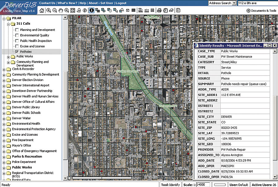
Local government agencies must not only maintain their service levels but also find new ways to improve operations while managing budgetary concerns. Combine this with the many challenges involved in promoting business growth, balancing environmental issues, and protecting the homeland, and the dynamic conditions give government officials a reason to carefully consider appropriate actions. The City and County of Denver (CCD), Colorado, is at the forefront of innovative GIS deployments. Denver has in place an advanced GIS department, known as DenverGIS, that serves the city's spatial data requirements on a daily basis. The City and County of Denver employs more than 5,000 people, with its Technology Services Department consisting of a staff of 265 people. DenverGIS has 16 GIS professionals ranging from GIS technicians to database administrators, programmers, and management staff. "DenverGIS continues to drive innovation and business improvements across departments and jurisdictions and plays a leadership role in Denver's technology strategy," says David Luhan, director of Geospatial Applications. "We have achieved a number of measurable benefits, including improved work efficiency, elimination of duplication efforts across departments, and increased productivity by accessing information that is linked through a spatial location." A Rich GIS TraditionThe greater Denver metropolitan area, and indeed the state of Colorado itself, has a long and rich GIS tradition and today is truly a hub of the GIS industry. The state has 250 private companies with 11,000 employees in GIS-related industries. It also possesses the most Esri business partners per capita in the nation. The City of Denver maintains a population of more than 557,000, with its greater metropolitan area encompassing eight counties and 2.6 million people. Within CCD alone, "One of every 62 city employees actively uses professional GIS software tools," says Luhan, "with GIS information being available to all employees through our Web-based tools." Prior to 1999, a few CCD departments maintained a number of department-specific GIS databases that were used for map generation, but each was managed independently in stovepipe environments, and the information was not easily shared across departments or functions. Enterprise standards did not exist, system integration was nearly impossible, there was no common operating picture for all departments, and citizen access to spatial information was limited. This situation resulted in a tremendous amount of duplicated effort and information existing both in hard-copy and inconsistent digital formats. With support from the Mayor's Office, the city made the decision in 1999 to move to a true enterprise-wide GIS environment that would leverage its resources, systems, and information from every corner of its organization. CCD hired Luhan as the director of Geospatial Applications. He was tasked with the leadership and management of the information technology staff who provide geospatial and statistical data services. CCD quickly began to develop a new enterprise GIS program from the ground up to provide data and services to more than 5,000 city users and the public each day. CCD outlined an initial strategy plan that included
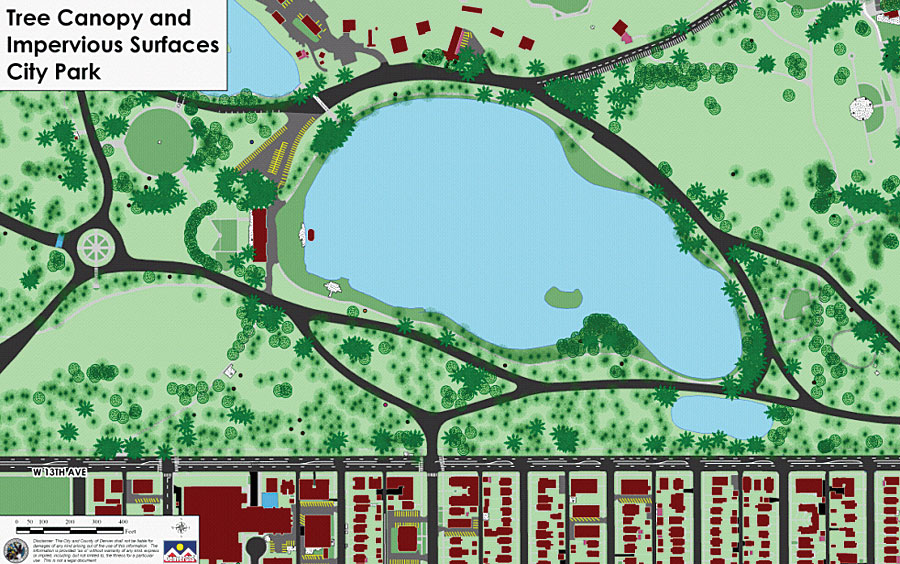
An extensive selection and benchmark process was carried out by the city's GIS Executive Committee and included demonstrations given to the City Council. The city chose to implement Esri GIS software for all aspects of its enterprise platform deployment because of its functional capability and the quality of its end results. Within six months, the initial DenverGIS platform was launched and has since expanded its infrastructure, personnel, and services to meet the daily program needs of more than 39 city departments and agencies in addition to other government jurisdictions. The city uses ArcGIS Desktop solutions, including ArcEditor and ArcView, as well as several other ArcGIS Desktop extensions. ArcSDE technology, with an underlying Oracle relational database, is used to update and manage data and to provide program support. ArcIMS and ArcGIS Server are used by both internal and external customers to query and locate information, visualize data, complete analysis, generate reports, and print and e-mail maps. Currently, there are 762 GIS data layers in CCD's geographic information resource, along with four years of aerial photography. All the information is managed by ArcSDE and accessible through ArcGIS Desktop and ArcIMS applications. Web services for address validation are currently being used within the city's 311 system, permitting application, and work order system. Information was developed through digital data conversion, aerial photography acquisition, planimetric data capture, geocoding database information, contractor deliverables, and results from spatial analysis. The GIS Successes Keep Growing"We strive to develop a complete GIS information resource that includes data both above and below ground that is developed with specific business functions in mind," says Luhan. "Within our implementation of a service-oriented architecture, ArcGIS Server will continue to play an increasing role in our service delivery strategy, including our regional common operating picture. GIS is making a difference in how our government agencies do their work, as well as how citizens and the communities live and work." One of the city's more recent GIS deployments helps people to understand what crime is happening in their communities and to work with government officials to identify, report, and respond to crimes taking place in their neighborhoods. Developed in conjunction with the Mayor's Office and the Denver Police Department by the city's GIS group, Denver residents, businesses, and visitors are now able to search up-to-date crime data and generate maps and tables of crime around homes, businesses, parks, schools, libraries, or neighborhoods. The system then displays a map of crime incidents and provides tabular information about each one. Information is updated daily though the police Records Management System as new crimes are reported and investigations yield new information. Certain information is withheld in order to avoid identifying juveniles or victims of sex crimes. "When the mayor took office more than four years ago, a primary focus of his was to improve public safety," says Luhan. "The mayor hired an independent monitor to take a look at how the police were doing their job, and one of the recommendations was the need to provide the community with a way to be more informed about what is going on in their neighborhood. Making crime information available to the public via the Internet has epitomized true community policing. GIS has assisted Denver's Crime Prevention and Control Commission to help reduce crime by more than 10 percent in 82 percent of the neighborhoods in the city." GIS has been extremely helpful in capital improvement and master planning for maintaining the quality of wastewater service and expanding capacity to support future development. The city's sanitary and storm sewer geodatabase has more than one million features, including mains, valves, outfalls, and manholes. It also includes a sophisticated geometric network that is linked to the Uniform Flow Model that allows staff to evaluate capacity based on current or projected conceptual land-use conditions. The city also recently launched Greenprint Denver, a comprehensive sustainable development initiative for a healthy environment and a strong economy. The plan takes into consideration economic, environmental, and social issues to improve the quality of life and environment within Denver. One of the goals of the initiative is to plant one million trees throughout the Denver metropolitan area in the next 20 years, tripling Denver's tree canopy from 6 percent to 18 percent. GIS plays a key role in helping the city do this by effectively tracking where trees have been planted. The city's Fire Department uses GIS to look at existing conditions and response times and to plan future strategies and tactics. In 2004, a Fire Facilities Master Plan was developed based on a comprehensive analysis of the Fire Department's existing facilities and performance requirements. It defined where new fire stations, training, and maintenance facilities should be built over the next 25 years. The analysis looked at such things as fire calls for service not meeting response time goals, station locations, detailed road network analysis, and future population and employment growth. Methodologies were developed in order to rerun analyses and produce repeatable results. Each year, the Fire Department's calls for service are geocoded and analyzed to make sure that planned fire stations will be built in the correct locations. The city will use DenverGIS to improve the permit, inspection, license, and plan review process. "Clearly this is an area where a service-oriented approach is required," says Luhan. "With multiple systems, applications, data warehouses, and live production processes that span multiple departments already in place, the challenge that needs to be met is a clearly defined process with a technology framework that supports customer objectives while maintaining safety and Denver's economic and quality-of-life objectives." More InformationFor more information, contact David Luhan, director of Geospatial Applications, City and County of Denver (e-mail: denvergis@ci.denver.co.us). |