ArcNews Online


    WINTER 2007/2008   COVER STORIES   T-SHIRTS WORLDWIDE
 
 
Winter 2007/2008 ArcNews cover, click to see enlargement

Now with exclusive online-only articles.

Previous Issues
Fall 2007
Summer 2007
Spring 2007
Winter 2006/2007

GIS Heroes have made a difference in the world by applying a GIS solution to a community problem.


What's New in ArcGIS Desktop 9.3
  ArcGIS 9.3 Expands the Power of GIS Throughout the Enterprise


Esri—A Review of 2007
  The ArcGIS Product Suite Continues to Expand


Understanding Our World: Further Thoughts on "The Geographic Approach," by Jack Dangermond


GIS Pioneer
Jacqueline daCosta Champions GIS


Esri Demonstrates Full Integration of SQL Server 2008 Spatial


What Holds Us Together
By Arthur Getis


|Includes Supplemental Podcast|
GIS for Small Governments: New Licensing Agreement Helps Deploy Enterprise-wide GIS


GIS and Science
By David Maguire


INSPIRE: The Value of Interoperability


Canadian National Road Network Defines State of the Art for National Datasets


The Evolution to Enterprise GIS
  Is Your GIS Enterprise?


China, South Dakota, and Utah—Great Places to Sport Esri T-Shirts

T-shirt Photos from Previous Issues


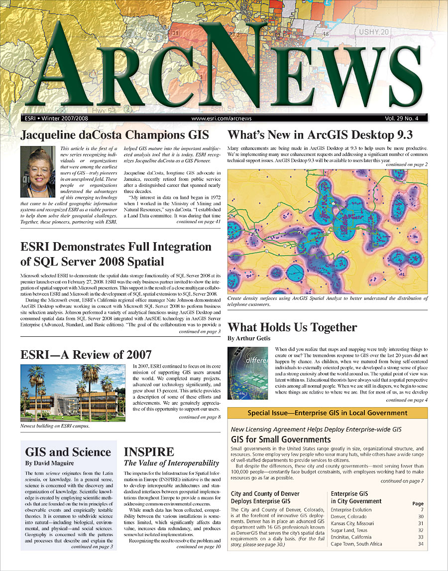
T-shirts Galore: Archive of all Previous T-shirt pages

"Crossing Borders" Series Articles by AAG Executive Director Doug Richardson

"Managing GIS" Series Articles by leading members of URISA
 

    GIS PRODUCT NEWS   GIS IN ACTION (cont'd)   GIS COMMUNITY NEWS
 
 
Create More Detailed Market Analyses: New Data and Features from Business Analyst Online

Build Dynamic Navigation Applications: StreetMap Mobile Software Developer Kit Now Available

Match Rates, Speed, and Customization Improved in ArcGIS 9.2 Geocoding Technology

Track Assets in Real Time: New Version of Tracking Server Gives Greater Data Viewing Control, Configuration Flexibility

|Includes Podcast|
ArcGIS Explorer: New Features, Expanded Resource Center

PLTS for ArcGIS Representations Distributable and Repeatable

 
  GIS IN ACTION
 
Qinghai-Tibet Railway Operations and Emergency Response Optimized with Enterprise GIS: Comprehensive Monitoring System Helps Safeguard Passengers

Autonomous Underwater Vehicle Mission Planning with GIS: The U.S. Naval Research Laboratory at Stennis Space Center, Mississippi

Pest Detection Enhance-ment and Survey Monitor-ing Through GIS in Florida

|Online Only Article|
Managing Several Different Architectural Subdivision Requirements: Design Standard Review Process Streamlined for City and Home Builders

Organizations Throughout North America Use Server Technology to Create Unique Web Maps

Water/Sewer/Storm Water Layer Developed: City of Safety Harbor, Florida, Uses GIS and GPS for Inventory Management and Planning


Grow That System: Saint John Energy Does It Right with GIS

Esri Business Partners' Offerings to the GIS Community

Improving Agriculture in Iraq: GIS Instrumental in the National Agro-Ecological Zoning Program

|Online Only Article|
School District, Public Reap Benefits of GIS: Success of Online Springfield, Illinois, School Location Application Is Widespread

Singapore Land Authority Simplifies Street Directory Production

Professionals Meet in Singapore for Geospatial Knowledge, Decision Making: Bringing Decision Makers Together

Watch Your Language While Mapping: Writing, Grammar, and Spelling—The Use of Text in Maps

California and Nevada Geographic Response Maps Created with GIS: Lake Tahoe and Truckee, Carson, and Walker River Basins Border Both States

Reducing Overhead with New GIS Application: BGC Engineering Generates Cross Sections with Ease

 
  ENTERPRISE GIS
  IN CITY GOVERNMENT
 
A Cornucopia of Spatial Applications: City and County of Denver Deploys Enterprise GIS for Improved Service Delivery

Enterprise GIS Connects the Entire City: Kansas City, Missouri, Centralizes the Data and Operations for Its Many Departments

Total Enterprise GIS in City Government

Realigning a City Cadastre Using New ArcGIS Survey Analyst: Enterprise GIS Connects Entire City of Encinitas, California

Cape Town's Emphasis on Systems Integration Exemplifies Smart City Goals


There's Something for Everyone at the 2008 Esri UC: The 2008 Esri International User Conference Will Be the Largest and Most Comprehensive Yet

|Includes Podcast|
ArcGIS 9.3 Previewed at Esri Federal User Conference: DOI Officials Kempthorne and Cason Address Users

A Canadian Experiment in Geographic Matters: Theme Days and Geography Awareness Week 2007

GIS Day Opens the Door to a Whole New Way of Thinking

Crossing Borders: A column by Doug Richardson
Reaching Out to Developing Regions

Foundational ArcGIS Desktop Training Series Redesigned for ArcGIS 9.3: Getting Started with GIS to Be Available Online

Managing GIS
Growing Up GIS
By Kim H. McDonough

Conferences in England and Chile: Esri International Events

URISA's Caribbean Activities Heat Up

Exclusive ArcNews Online Articles

New Approaches to Map Design and Historical Scholarship: Two New Esri Press Books

|Includes Podcasts|
New Training and Education Offerings from Esri

William L. Garrison Award for Best Dissertation in Computational Geography: Deadline for Nominations—September 2, 2008

Career Opportunities at Esri

Listen to Esri Podcasts

Free Esri Publications

GIS Greatest Hits


Contact Us | Privacy | Legal | Site Map