Through the Macroscope: Geography's View of the World
By Jerome E. Dobson, Professor of Geography, University of Kansas
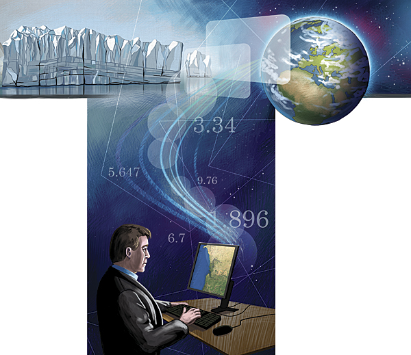
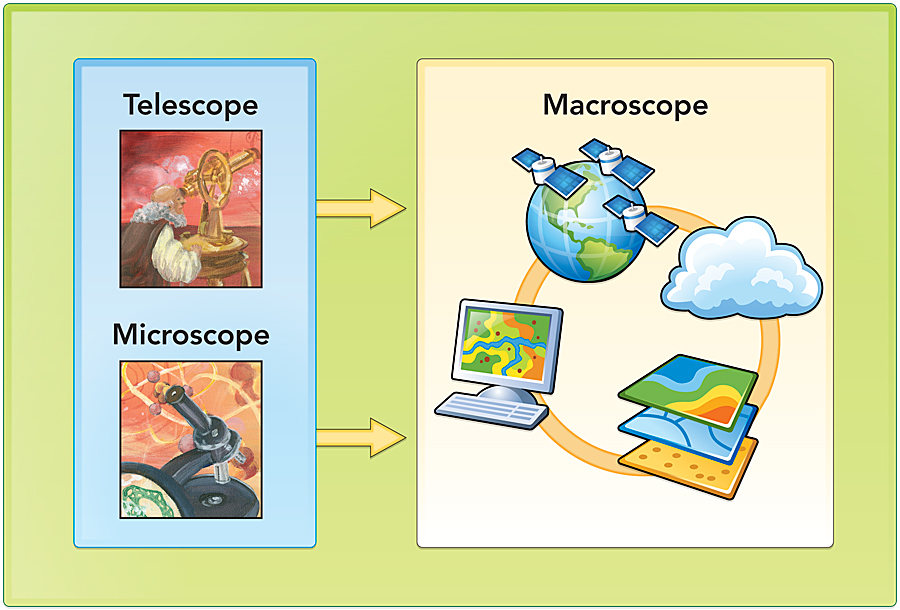
 We have in our hands a new scientific instrument as powerful as any that have come before it, including the microscope and telescope. Collectively, GIS, GPS, satellite remote sensing, and popular geographics constitute a macroscope that allows scientists, practitioners, and the public alike to view the earth as never before.
Today, this geographically enabled macroscope (which was first proposed by Jo�l de Rosnay in 1975) allows humans to visualize earth processes extending over vast regions or even the whole globe while still maintaining the finest measurable detail. We who use it can capture and analyze far more complete representations of places and features than ever before. We can "see" earth features, such as gravity and magnetism, that are invisible to the naked eye and yet as real and commanding as the mountains and valleys we've seen all along. Most important, we can marshal this diverse information into working models of earth processes large and small.
The microscope allowed humans to see smaller particles and organisms and led to scientific revolutions in biology, medicine, and nuclear physics. The telescope allowed humans to see farther away with greater detail and led to revolutions in astronomy and geodesy.
Will the macroscope similarly lead to scientific revolutions of its own? Will it change the way science itself is conducted, as those earlier instruments did? Has this scientific revolution already begun? Yes, but it has done so slowly and mostly unrecognized by pundits and the public alike.
In 2008, the Proceedings of the National Academy of Sciences announced that cattle and deer can sense magnetism. Biologists in Germany and the Czech Republic discovered this amazing and previously unsuspected phenomenon not by sensing brainwaves or measuring body chemistry but by "analysis of satellite images, field observations, and measuring 'deer beds' in snow."
In the 1990s, a geophysicist solved a mystery that had perplexed hydrologists for decades—a significant portion of the global transport of water had never been explained. Perusing satellite imagery, he suddenly realized that the answer lay in vast currents of water vapor drifting through the atmosphere. He calculated their mass and followed their flows and found the H2O that had been missing from the global water cycle equation.
Thus, in two diverse realms of science, the geographically enabled macroscope actively bolstered the analytic powers of specialized disciplines. Where will this lead?
Geography in the Crucible of Science
Is geography a science? Yes, most definitely, because science would be diminished too much without it.
In classical times, geography was viewed as a fundamental science and humanity on par, at least, with the specialized disciplines of today. During the Middle Ages in Europe, however, notions of real-world geography devolved into fantasies, and no term for geography was in common usage even in the highest realms of government and academe. The discipline thrived again from the mid-15th to mid-20th centuries based on an evolving chain of influences from exploration to westward expansion to geopolitics. Since 1948, however, geography has undergone a second academic purge, primarily in the United States, and the word itself has lost ground to a host of popular aliases, geospatial not least among them.
Finally, we practitioners have an instrument that potentially enables us to reinstate geography in science as it was practiced in classical times and in the Renaissance. What will science, enhanced by the macroscope, look like a generation or more from now?
First, we, its stewards, must decide what to do with this new instrument and what role we will play in the science that follows. Will geographers and GIScientists drive the revolution or merely go along for the ride? In the case of animal magnetism, for instance, why didn't we, who worked intensely with such imagery for decades, notice this odd phenomenon long before the biologists did? In the case of global water circulation, why didn't we, who used the imagery routinely and knew its spectral characteristics so well, make that discovery ourselves? Instead, we spent enormous efforts trying to get rid of the haze that was blocking our view of the ground but was, for the geophysicist, the key to a scientific breakthrough of historic proportions.
Bluntly, how did we get scooped on major discoveries so easily resolved with our own data? Why was science held back until biologists and geophysicists discovered those insights themselves? Surely, we must rethink our own functions, motivations, and pursuits if we want to be the ones making discoveries, grabbing headlines, and gaining financial and administrative support for our work.
How Will Geography Itself Fare?
By any measure, geography has been remarkably productive in the past half-century, and yet department after department has been closed. In 2007, I wrote in ArcNews that only two geography departments remained in the top 20 private universities in the United States. Four years later, no viable ones are left. The University of Southern California abolished its geography department in favor of a geospatial technology program, and Johns Hopkins University's Department of Geography and Environmental Engineering slipped to only two geographers in a faculty of 18.
To anyone who values education, it should be self-evident that such widespread blindness toward any discipline inevitably must have a damaging impact on science itself. Accordingly, I offer two propositions:
- Proposition 1—Science itself is rife with errors and omissions due to lack of geographic input in formulation and testing of theory.
- Proposition 2—Any well-trained geographer or GIScientist who focuses on any popular tenet of conventional theory, emphasizes the missing spatial components, and works conscientiously can make groundbreaking discoveries in one year of elapsed time. In common English, I am suggesting that earth science as a whole is so flawed by lack of spatial thinking that there will be "easy picking" and lots of "low-hanging fruit." Discoveries will come easily, but acceptance may take decades, since that depends on the culture of science far more than factual evidence.
To illustrate, let's focus on continental drift, as suggested by de Rosnay in The Macroscope: "Around the concept of continental drift it is possible to teach the complementary aspects of geography, geology, biology, and ecology. . . ." Then I will focus on another of my favorite topics, the origins of human culture.
Continental Drift and Plate Tectonics
There is no better case than plate tectonics to demonstrate the abiding value of spatial evidence and, simultaneously, society's habitual rejection of it. Starting with the European discovery of the Americas, it took about half a century to produce a decent map of their coasts and only another half-century for Abraham Ortelius to notice the fit between South America and Africa and propose they must once have been joined. In the third edition of his popular text Thesaurus Geographicus (1596), he proposed the theory of continental drift in no uncertain terms. Yet there is no known instance of anyone citing his remarkable insight over the next four centuries. Others did reach the same conclusion—Lilienthal (1756), DeBrahm (1771), Snider-Pellegrini (1858)—always based on the fit of coasts, but all were ignored or dismissed until Alfred Wegener in 1912. Soon, he too was rejected and ridiculed for his unconventional theory until ocean floor spreading was discovered and accepted as proof in the early 1960s.
For thousands of years, the interplay of our community—geographers, cartographers, geodesists, and surveyors—with the rest of science was central to the advancement of fundamental theories, including plate tectonics. Sometimes we led science theory, as when Bouguer found that mountains are lighter than other crust (1737–1740) and the Great Trigonometrical Survey of India confirmed his findings (early 1850s), and together they laid the foundations for current understandings of plate tectonics. Sometimes we proved the grand theories of others, as when de Maupertuis (1736) and La Condamine (1736–1743) proved that the earth bulges at its middle, thus confirming Isaac Newton's theory that centrifugal force opposes gravity in planetary motions.
Still, we somehow never managed to claim a place among the authoritative disciplines in that realm of science, even though much of it is called paleogeography. One major factor is the scientific community's overwhelming preference for process logic over spatial logic. Spatial logic accepts morphology, spatial distribution, and spatial association as primary evidence of earth processes that must be tested through process-oriented research. Conversely, process logic accepts contemporary knowledge about individual earth processes; synthesizes general theory; and proposes all sorts of tests, though rarely are the tests overtly spatial.
Today, the macroscope has much to offer, opportunities abound, and dramatic new insights are likely. Geographers, cartographers, and GIScientists are ideally suited, for instance, to verify previously discovered continental fits and search for new ones. Likewise, our community is the one most capable of developing a spatial statistic to measure the probability of fit among coastlines. In GIS per se, it's up to us to develop the functionality to move land masses independent of earth coordinates. When available, this new capability should be used to follow all paths connecting known or suspected continental fits. The ultimate challenge, of course, will be to disassemble all land masses into their geologic formations; run spatial statistics, such as principal components analysis, to determine their affinities to one another based on age, lithology, paleontology, polarity, and elevation/bathymetry; and then reassemble the whole earth based on evidence rather than theory.
The rewards may be invaluable for understanding deep earth processes, estimating seismic risks, reconstructing the paleogeography of plant and animal life, predicting the distributions of oil and other essential minerals, and scores of revelations yet to come.
Origins of Human Culture
Take a look at the graph of global sea level rise below, annotated to show how long each zone was exposed. Has anyone ever told you that for 104,000 years, the world ocean remained at least 25 meters lower than it is today? That for 59,000 years, it was at least 68 meters lower, and for 35,000 years, it was at least 85 meters lower? That geographic information has to be the single most important clue to how and where humans developed into the sentient beings of today. Yet scientists routinely call the old coast a "land bridge," as if it were only good for getting from one place exposed today to another place exposed today (e.g., Siberia to Alaska, Asia to Japan, Australia to Tasmania).
Make no mistake. That was a vast coastal plain, and people surely lived there.
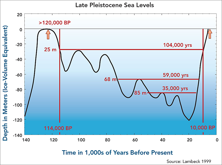
Global sea level rise and the number of years each zone was exposed.
The rise and fall of sea level during the ice ages—due to water tied up in ice sheets and then released during interglacial periods—is like a vast millennial tide, and its total area is equivalent to the continent of North America in size. It is flat, coastal, and mostly tropical and would have been the best place to live during the ice ages. Yet we collectively have never mapped it or agreed on a name for it.
Here again, the opportunities for geographic revelations are boundless. Our community is the one best suited to map the land that was inundated. We can trace the old coasts at various stages and times over the past 120,000 years and predict likely settlement sites and trade routes. We can document authoritative and unproven claims of ancient structures on land and underwater, entering them into a proper GIS with precise coordinates, attributes, and confidence levels. Ultimately, we can build a 3D geovisualization so the land now below sea level can be studied like the land above.
The rewards will be invaluable for understanding the human and biophysical processes operating during the ice ages. Consider, for instance, that sediments deposited from the ice sheets of 20,000 years ago do not lie in the deltas of today but rather in the old deltas, 400 feet down. The greatest scientific revolution, however, may lie in better understanding of human evolution itself, since several glaciation cycles coincide with the time period, 120,000 years, in which modern humans are known to have existed.
"Aha!" Revolution Under Way. Mind Your Step.
I've had a few "aha" moments enabled by the macroscope.
First, once, while conducting fieldwork in the Adirondack Mountains of New York State at the center of the acid rain debate, I found myself in a forest so dense and disturbed that I could shoulder forward at no more than one-half mile per hour. I could see merely a few feet ahead, but I had with me a map of land-cover types previously classified in the laboratory—a bit of the macroscope, one might say. Checking the map, I realized the unusual forest before me went on for miles in every direction. More important, it displayed a discernible pattern that revealed dramatic new insights into the lake acidification process that so concerned the nation at the time.
Second, while working in Liberia in 1981, my attention was drawn to the geographic distribution of mineral deposits in West Africa, which I later compared to those of South America. That line of reasoning, enhanced by the macroscope, soon led to numerous continental fits that had never been noted before. Now, as always since 1596, the question is: Do continental fits imply adjacency? In terms of pure geometry, South America fits beautifully when turned 90 degrees clockwise from its traditional fit with Africa, and Australia exquisitely matches eastern North America. Both fits have considerable geologic evidence in their favor as well. But does that mean each pair actually did lie side by side at some time in its geologic past? The centuries-old lopsided debate lumbers on.
Third, years later, reading a science magazine, I ran across a forthright statement that sea level had risen 400 feet over the past 20,000 years. I immediately saw it as the key to a mystery that had puzzled me since boyhood. That aha moment prompted a series of geographic questions: What is missing from the archaeological record? Were coastal populations identical to inland populations? Might there have been some factor, cultural or physical, that caused systematic differences between coastal and interior people? My brother Jeff Dobson, also a geographer, pointed out that iodine is primarily a coastal resource. Noting that Neanderthals lived primarily in places that are iodine deficient today, I spent several years investigating iodine in human evolution.
My purpose here is not to discuss the insights themselves, and certainly not to prove that I was right, but rather to share some lessons learned from the overall experience.
These three experiences in diverse realms of science support, first and foremost, both of the propositions stated above. Clearly, there is much left to discover, and our community is in an ideal position to advance the macroscope and support or lead the coming revolution in science theory.
Furthermore, there is much personal satisfaction awaiting those who take up the gauntlet and wield the macroscope to advance science theory. After each of the aha moments listed above, I came down from the mountain—literally in one case and figuratively in the others—so elated that adrenaline fueled my research for several years to come.
But the road will not be easy. Revolutions always stir passions. Prepare yourself for praise from those who appreciate spatial logic but rejection, even humiliation at times, from those who don't.
Fervor is essential. Wegener's own father-in-law, the renowned climatologist Wladimir K�ppen, advised him not to publish his revolutionary theory for fear of the damage it would do to his reputation and career. How different the history of earth science might have been if Wegener had shown less fervor . . . or Ortelius had shown more.
Ultimately, it will be essential to upgrade the scientific method. Our community must insist on testing all earth science hypotheses for space as well as time, entity, and process. We must insist that all other disciplines live up to our standards, which are far more demanding in terms of space.
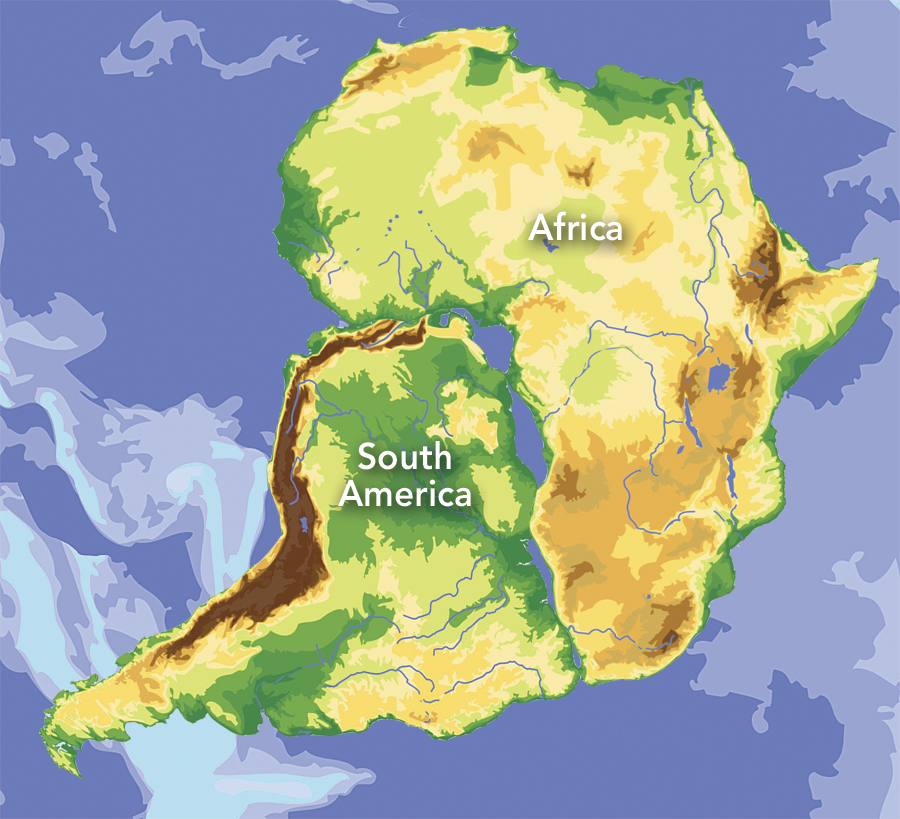
The macroscope enables, and even entices, its users to view old questions in new ways. In terms of pure geometry, for instance, South America may fit Africa better when rotated 90 degrees clockwise than it does in the fit that has been observed for four centuries.
It will be essential to allow investigators to ask "stupid" questions arising from spatial evidence without penalty, as long as they truly ask and do not proclaim unproven truths. Otherwise, science will throttle its best and brightest minds—those most suited to the new way of thinking—and hold back the advancement of science theory.
A concrete step in this direction will be to recognize a new grade of hypotheses so encompassing that testing requires simultaneously or subsequently rethinking many related hypotheses and even widely accepted theories. Perhaps they should be called hypertheses (meaning "above or beyond") rather than hypotheses. At present, there is no middle ground between an individual hypothesis proposed for testing and an encompassing theory widely accepted by many scholars in any given field. Hence, conventional wisdom based on popular theory often trumps the facts at hand without prompting much reconsideration of existing theory. Alternatively, hypertheses could be tested first for their central claim and then, if found solid, would force rigorous testing of related hypotheses and theories.
The macroscope is here today, and science is already changing in response to it. We are entering a new scientific era that may be every bit as exciting and enlightening as the revolutions prompted earlier by the microscope and telescope. Surely our professional lives will be richer, and science itself will gain, if we, who know the marvelous instrument best, insist on using it ourselves to tackle the greatest mysteries of our time. Surely we must insist on reviving the classical model in which geography is viewed as a fundamental discipline.
Again, I urge, bring back geography! To science . . . education . . . business . . . and government! The benefits to science and society will be incalculable.
About the Author
Jerome Dobson is president of the American Geographical Society and a professor of geography at the University of Kansas. He is a Jefferson Science Fellow, a fellow of the American Association for the Advancement of Science, and chair of fellows of the University Consortium for Geographic Information Science. He formerly served as senior scientist in the Office of the Geographer and Global Issues, United States Department of State, and as a member of the distinguished research and development staff, Oak Ridge National Laboratory. For further reading, see the author's previous ArcNews article "Bring Back Geography!" (Spring 2007). Also see:
Dobson, Jerome E., Richard M. Rush, and Robert W. Peplies. 1990. "Forest Blowdown and Lake Acidification," Annals of the Association of American Geographers 80(3): 343–361.
Dobson, J. E. 1992. "Spatial Logic in Paleogeography and the Explanation of Continental Drift," Annals of the Association of American Geographers 82(2): 187–206.
Dobson, J. E. 1996. "A Paleogeographic Link Between Australia and Eastern North America: A New England Connection?" Journal of Biogeography 23: 609–617.
Dobson, J. E. 1998. "The Iodine Factor in Health and Evolution," Geographical Review 88(1): 1–28.
For more information, contact Jerome E. Dobson, University of Kansas (e-mail: dobson@ku.edu).
See also "The STEP Model" and "Popular Geographics."