 The Magazine for
Esri Software Users |
|
|
Risk Analysis and Response
GIS and Public Safety
Concern for public safety has grown in the wake of numerous and costly emergencies in recent years. Events such as Hurricane Mitch have been costly not only in dollars but in human suffering. Deemed one of the worst natural disasters in the western hemisphere in this century, Hurricane Mitch roared into Central America on October 26, 1999, causing six billion dollars in losses to the region, killing more than 10,000 people, and leaving another 1.5 million people homeless.
GIS was instrumental in recovery efforts for this area. Esri joined with the United States Geological Survey (USGS), Silicon Graphics, Hewlett-Packard, Motorola, and Microsoft in sending computer systems equipped with GIS software and databases to the region. These systems were used to coordinate and prioritize rescue and relief efforts. The Central America Disaster Atlas, created by a team of volunteers from the USGS and Esri, was distributed to Honduran and international agencies so they could create accurate maps to guide rescue, relief, and reconstruction operations.
Preparing for the Worst
Vulnerability and sustainability are two key concepts for those charged with protecting communities from dangers both natural and man-made. To assess vulnerability, hazards such as floodplains, areas of earthquake activity, and neighborhoods with high crime rates must be located. Risk analysis-determining what is most likely to happen in these high-risk areas based on historical data and spatial analysis-focuses and prioritizes prevention and planning efforts. Analyzing hazard and risk information with demographics will help determine who will be affected.
The ability of GIS to create "what-if" scenarios is tremendously valuable in assessing the vulnerability of a community or area. 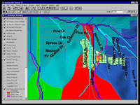 "Modeling the Raging Waters of Forest Falls," an article in this issue of ArcUser magazine, describes how readily-available data was used to model a violent rainstorm and mudslide that occurred in the San Bernardino National Forest. ArcView GIS with the ArcView Spatial Analyst extension provided all the tools needed to combine data from many sources, derive additional themes, and analyze the information. This article illustrates how the effects of natural disasters can be estimated so that mitigation efforts and emergency response can be planned. "Modeling the Raging Waters of Forest Falls," an article in this issue of ArcUser magazine, describes how readily-available data was used to model a violent rainstorm and mudslide that occurred in the San Bernardino National Forest. ArcView GIS with the ArcView Spatial Analyst extension provided all the tools needed to combine data from many sources, derive additional themes, and analyze the information. This article illustrates how the effects of natural disasters can be estimated so that mitigation efforts and emergency response can be planned.
A National Imperative
The Federal Emergency Management Agency (FEMA), an independent federal agency charged with reducing loss of life and property and protecting the nation's infrastructure from hazards, is sponsoring Project Impact.
 The goal of this nationwide initiative is to identify vulnerable areas and help develop more sustainable communities. Project Impact helps communities deal more effectively with natural disasters by using the latest technology, including GIS. The program has helped minimize loss and disruption from floods, hurricanes, and other emergencies. Project Impact operates on the local level encouraging communities to become more disaster resistant by reviewing and enforcing building codes, identifying at-risk structures, and preventing development in high-risk areas. The goal of this nationwide initiative is to identify vulnerable areas and help develop more sustainable communities. Project Impact helps communities deal more effectively with natural disasters by using the latest technology, including GIS. The program has helped minimize loss and disruption from floods, hurricanes, and other emergencies. Project Impact operates on the local level encouraging communities to become more disaster resistant by reviewing and enforcing building codes, identifying at-risk structures, and preventing development in high-risk areas.
Through Project Impact, FEMA partners with area businesses and helps assess risk and prioritize needs by offering expertise and technical assistance from the national and regional level. From a pilot program of seven communities, the number of communities participating in Project Impact has grown to 120 and more than 1,000 businesses are participating in the project. New Hanover County, North Carolina, one of the original seven pilot communities, developed a GIS-based methodology for conducting community-wide vulnerability assessment.
GIS-Based Tools
GIS has proved a powerful tool for assessing risk and prioritizing needs. An earthquake loss estimation software application called HAZUS has been developed as part of Project Impact and is available at no charge to state and local governments. HAZUS works with ArcView GIS to produce detailed maps and analytical reports that describe a community's potential losses.
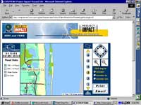
As part of Project Impact's program to educate the public about natural disasters, FEMA added online mapping of tornadoes, hurricanes, hailstorms, earthquakes, windstorms, and flood information. Esri developed and hosts the hazard maps site where visitors can build maps that show the history of natural disasters for ZIP Code areas, towns, or congressional districts.
The Project Impact Community Challenge Grant program, sponsored by Esri, supports the use of GIS as a tool for effectively creating disaster-resistant communities. Grants will be awarded to communities with innovative proposals for using GIS to develop or implement damage prevention strategies. Esri will provide software and training grants totaling approximately $100,000 and FEMA will provide training and technical assistance. Selected communities will be featured in the public safety sessions at the 2000 Esri International User Conference and the 2000 Project Impact Summit.
On the Local Level
Not only is GIS effectively used by national and state agencies responding to regional emergencies, government agencies on the local level, such as fire agencies and law enforcement organizations, are adopting GIS. They have found GIS invaluable in planning strategic response, developing tactical response plans for incidents, formulating and carrying out mitigation programs, and analyzing incident data for training and policy-making purposes. This issue of ArcUser contains an article that provides an overview of the kinds of sophisticated applications that fire agencies have developed to safeguard communities.
Protecting communities also includes another less dramatic but very important aspect-the day-to-day maintenance of the infrastructure that supports emergency response. The City of Euless, Texas, used GIS and GPS to inventory fire hydrants and integrate that data with an incident reporting and computerized response preplanning system the City was adopting. Their efforts are described in an article in this issue.
Human Threats
Sometimes the threat to public safety is man-made. Esri business partners such as Science Applications International Corporation (SAIC) of Newport, Rhode Island, have developed a powerful GIS-based tool using Esri technology. 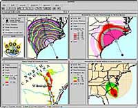 SAIC's Consequences Assessment Tool Set (CATS) software combines advanced computer models, databases, and GIS software. It can be used for actual emergencies, contingency and logistical planning, and consequences management. In addition to helping cope with natural disasters, CATS can be used for handling man-made hazards such as bioterrorist attack. CATS uses ArcView GIS and ArcView Spatial Analyst and comes with a wide range of georeferenced land, demographic, and infrastructure information accessed via the Internet from database sources. CATS has been used for pre- or post-disaster planning and/or response for more than 20 hurricanes as well as the 1994 Northridge earthquake in California; the G8 Summit in Denver, Colorado; and the 1996 presidential inauguration. SAIC's Consequences Assessment Tool Set (CATS) software combines advanced computer models, databases, and GIS software. It can be used for actual emergencies, contingency and logistical planning, and consequences management. In addition to helping cope with natural disasters, CATS can be used for handling man-made hazards such as bioterrorist attack. CATS uses ArcView GIS and ArcView Spatial Analyst and comes with a wide range of georeferenced land, demographic, and infrastructure information accessed via the Internet from database sources. CATS has been used for pre- or post-disaster planning and/or response for more than 20 hurricanes as well as the 1994 Northridge earthquake in California; the G8 Summit in Denver, Colorado; and the 1996 presidential inauguration.
Law enforcement's efforts in safeguarding communities have been enhanced in recent years by the growing use of GIS. Though computer mapping has been used as a tool for law enforcement since the 1970s, the use of GIS has increased exponentially in the last four years with the availability of more robust and user-friendly desktop GIS applications. GIS lets agencies utilize more information more intelligently by querying over political boundaries. GIS-based searches are far more efficient than paper document-based searches or straight database searches.
Crime analysis tasks, such as incident location, identification of gang territories, and integration of image data with database information, benefit from the use of GIS. Linking information in several databases to an incident location lets officers see the history of incidents at an address. Access to this breadth of information promotes development of strategies for dealing with ongoing situations and aids in completing investigations.
GIS not only helps analyze crime trends, but it can also be used to more effectively manage agency resources. Balancing workloads by drawing up more equitable beats and evaluating the results of selective traffic enforcement plans are just two ways GIS helps coordinate feedback and allocate resources. An article in this issue of ArcUser magazine describes how the Illinois State Police (ISP) department used GIS tomore effectively deploy officers. ISP identified problem areas and pursued an enforcement program that improved public safety on the State's highways by dramatically reducing traffic fatalities. The success of that program spurred the department to use GIS to disseminate information to management, troopers in the field, and the public.
Esri has also helped develop new applications for law enforcement. The Community Policing Beatbook, built with MapObjects technology and funded by the National Institute of Justice (NIJ), is an in-vehicle application that gives mapping tools, neighborhood, and crime activity information to officers in the field. The Crime Analysis extension to ArcView GIS was also developed with funding from the NIJ's Crime Mapping Research Center. Both applications are available from the Esri Law Enforcement Web page. The Spatial Crime Analysis System (SCAS), another downloadable extension developed using ArcView GIS and Visual Basic, is available from the United States Department of Justice Web site.
Whether preventing, responding, or mitigating the effects of man-made or natural perils, GIS is an invaluable tool for the agencies and organizations that safeguard communities.
Contact Russ Johnson
Public Safety and
Emergency Management Agencies Solutions Manager
Tel.: 909-793-2853, ext. 1-1836
E-mail: russ_johnson@esri.com
or
Lew Nelson
Law Enforcement and
Criminal Justice Solutions Manager
Tel.: 909-793-2853, ext. 1-1690
E-mail: lnelson@esri.com.
|
