Access to Better Information for Public Health
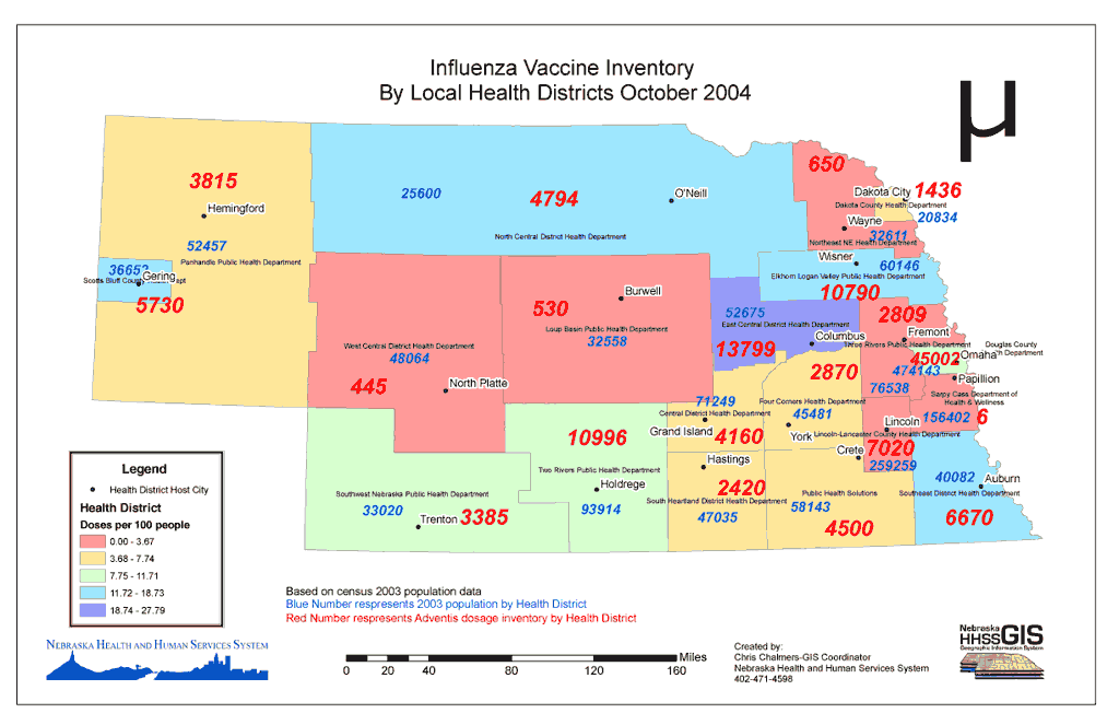
When vaccine manufacturer Chiron Corporation announced no flu vaccine would be shipped for the 2004–2005 season, Nebraska Health and Human Services System (HHSS) officials determined within days both the current vaccine supply and the amount of vaccine needed for every health district in the state. Once this assessment was made, HHSS developed an effective methodology for distributing scarce vaccine supplies. Weekly updates on the state of flu vaccine inventories helped reallocate supplies and ensure all citizens on the priority list could be vaccinated.
 |
| Facing a flu vaccine shortage for the 2004-2005 flu season, Nebraska public health officials rapidly determined both the current vaccine supply and the anticipated demand using GIS. |
The information for quickly assessing the situation and formulating and modifying response efforts was supplied by the agency's GIS. Increasingly, public health officials are relying on GIS. From its original role in epidemiological research, GIS use in public health has expanded both in the number of organizations using it and the types of applications being developed. GIS now provides a framework for managing the broad range of challenges faced by public health practitioners and decision makers. From detecting and responding to infectious disease outbreaks to delivering services to preserving the safety of the water supply and food chain, the data integration and analysis capabilities of GIS are supplying better access to information, not just data.
Disease outbreaks are strongly linked to both the physical and socioeconomic environment. For example, in areas lacking safe water supplies, cholera is often a problem. Malaria typically occurs in areas favorable to proliferation of mosquitoes. The incidence of HIV/AIDS has been shown to correlate with the transportation network in an outbreak area.
As noted last year by epidemiologist Dr. Rita R. Colwell during her keynote address at the Esri International User Conference, "Geography is the original multidisciplinary field." GIS has allowed researchers to use a more integrative approach to understanding the complex interactions between biological systems and the physical environment.
The National Cancer Institute (NCI) illustrates the many ways a health organization can use GIS in integrating numerous data sources and evaluating the interplay of diverse factors. NCI has developed a broad range of GIS-based applications for exploring geographic patterns in cancer incidence, tracking detection and outcomes at the community level, assessing environmental exposure, modeling cancer prevalence and survival by state, identifying health disparities, and communicating with the public and other researchers. Geography provides the framework for better understanding cancer.
Geography matters in the detection, monitoring, and response to disease outbreaks. In this highly mobile world, diseases can now travel farther and faster than ever before. Since the first cases were identified in 1981, HIV/AIDS has rapidly spread throughout the world and caused 20 million deaths. According to UNAIDS, a joint United Nations program on HIV/AIDS, more than 38 million people currently are infected with HIV.
In Africa, HIV/AIDS does not constitute a single epidemic. Outbreaks vary greatly across the continent and the prevalence of the disease ranges from a low of 2 percent in some countries to a high of 35 percent in others. In Sub-Saharan Africa, the region hit hardest by HIV/AIDS, 25.4 million people live with HIV.
GIS is helping manage the treatment of people in Africa who are living with HIV. The CellLife project in South Africa integrates GIS with other technologies to more efficiently gather information for distributing medication. This project combines cell phone applications, database applications on the Internet, an HIV/AIDS database, and GIS to help medical staff effectively administer antiretroviral medication to HIV-positive individuals.
In addition to diseases that have emerged recently, such as HIV/AIDS, public health agencies battle diseases that have plagued mankind since ancient times. The symptoms of malaria were described in Chinese medical writings as early as 2700 BCE, and the disease remains a threat. Of 300 million acute cases of malaria each year, one million result in death. In addition to individual suffering, it is a disease that is both characteristic of poverty and a cause of poverty. The substantial personal and public expenditures for prevention, treatment, and lost productivity can be economically debilitating.
GIS has proved valuable not only for monitoring outbreaks but also for administering eradication programs and gauging their effectiveness. An article on page 22 of this issue describes how public health researchers working in Africa used GIS to determine the most efficient method for distributing insecticide-treated bed netting. Their analysis also ruled out any adverse effects for families that did not receive treated bed netting.
The Harris County Public Health Department's efforts in combating West Nile virus and other mosquito-borne diseases are also described in this issue. The Texas county conducts disease surveillance and tests the effectiveness of its abatement programs using GIS for field collection work, research, analysis, and public notification.
In some cases, public health officials face infectious diseases that are in a sense both old and new. New strains of familiar infectious diseases, such as Vibrio cholerae 0 139, a new cholera serogroup identified in 1992, can potentially trigger new pandemics because immunity to more familiar types often does not confer immunity to newer versions of a disease. Added to concerns over naturally occurring mutations, public health officials must also prepare for outbreaks of mutated infectious diseases that result from terrorist activities.
Threats to public health come not only from direct transmissions of disease but also from indirect transmission caused by compromises to the safety of the food supply chain. These outbreaks might also be deliberately caused as well as naturally occurring. The United States Department of Agriculture is implementing an animal tracking program, focused primarily on livestock animals, that will use GIS and other information technologies to identify affected premises and exposed animals within 48 hours of detecting an infected animal.
Animal tracking systems represent one component of the overarching disease surveillance program outlined in another article in this issue of ArcUser. "Extending Disease Surveillance with GIS" sets out a blueprint for multiplatform GIS-based surveillance systems at several levels from regional to global. In addition to the familiar workstation implementation, GIS has evolved into a mainstream IT technology that is at home on the Web, operates on portable devices, functions on the server, and is embedded in other applications. Public health practitioners and decision makers can now implement a comprehensive approach for handling threats from infectious diseases.
In addition to developing multiplatform, standards-based GIS software, Esri is collaborating with researchers at the University of California, Santa Barbara; public health planning and research organizations; public health consulting firms; and GIS coordinators from medical centers around the country in creating the Health Data Model (HDM). Private health consultants, Esri business partners, software developers, and university faculty are also involved in this project, which is headed by Dr. Michael Goodchild.
Data models are industry-specific templates that speed the development of projects and encourage interoperability and data exchange by supporting existing standards. The HDM can add a spatial dimension to general purpose health models and provide immediate and long-term benefits to those working on public health GIS applications. Currently HDM work focuses on issues related to service site selection, facility emergency response, campus facility management, regional environmental health, and disease surveillance. Visit www.esri.com/arcgisdatamodels for more information on HDM and other data models.
The value of GIS in public health is being widely recognized. A conference for health care executives and decision makers from Africa, Europe, and the Middle East was recently cosponsored by Esri, HP, SAP, and Microsoft. "Health Care Institutions-the Balancing Act of Offering Excellent Health Care Services and Controlling Health Budget" focused on using IT to meet the growing demands and cost of health care systems. The conference, held March 16-17, 2005, in Vienna, Austria, addressed the integration of GIS with enterprise resource planning and databases. For more information on developing more effective public health strategies using GIS, visit www.esri.com/health or contact
Bill Davenhall
Health and Human Services Solutions Manager
Tel.: 909-793-2853, ext. 1-1714
E-mail: bdavenhall@esri.com
|