Going Beyond the Physical Community
Continued...
The Chinese Cemetery
The year 2005 marked the 150th anniversary of the arrival of the first Chinese immigrants to Jamaica. Initially these immigrants arrived to work as indentured workers in the post-slavery era. Soon they became an integral part of the developing peasant economy and burgeoning local commercial retail sector and established shops that served the newly freed working class. Presently, the Jamaican Chinese population makes up only about 3 percent of the population, but it plays a very important role in Jamaican life. It claims successful businessmen and women, entrepreneurs, scientists, politicians, and artists. The cemetery affords an opportunity for these people, as well as the wider society, to track the rich history of the Chinese in Jamaica.
The Chinese Cemetery was consecrated in 1929 as a final resting place for the growing number of Jamaican Chinese, then in its third generation. The cemetery offered a dignified and traditional resting place for the Chinese as an alternative to the existing colonial-style graveyards and cemeteries. However, over the past few decades, the communities surrounding the cemetery have severely deteriorated with associated physical, social, and economic degradation of the area. Individuals are afraid to venture to the cemetery anymore, and the cemetery's fate has reflected that of the wider area. Whole generations have no idea that the cemetery exists. While there is an effort under way to restore the place, the sobering reality is that a true fix would need to address the broader socioeconomic problem that plagues the region; without this, the cemetery would fall apart again.
Much of the cemetery is in disarray, and many graves have been defaced. The damage includes broken headstones, decrepit crypts, and accumulated garbage. Animals graze throughout the property. The cemetery archives are stored in a nondigital format that is mostly written in Chinese and cannot be read by most later-generation Jamaican Chinese. These were the challenges faced by those tackling this project, which was code named The Necropolis Project.
GIS is being used to properly catalog the graves in the cemetery and create a digital archive and virtual cemetery that will help those who are seeking loved ones but are unable or afraid to venture into the cemetery. Several articles about using GIS to map cemeteries in Idaho and Colorado have appeared in ArcNews magazine (Winter 2002/2003 and Spring 2004 editions), but this project is the first attempt at this type of application in Jamaica.
Graves were individually mapped using GPS units from Trimble and Garmin and cross-referenced against archived grave listings provided by the Chinese Benevolent Association, the owner of the cemetery. Satellite Imaging Corporation's IKONOS satellite imagery, provided by the Ministry of Land and Environment and the University of the West Indies, was also used to locate and map portions of the cemetery, particularly the outer wall, subsections within the cemetery, and main gathering areas.
ArcView 3.2 and ArcGIS 9.1 were used for mapping, measurement, attribute tagging, querying, and other GIS activities. Similar tasks were carried out on each platform. Of the 2,834 graves that have been mapped so far, 2,070 names have been positively identified. The remaining graves
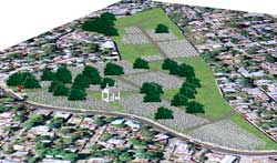 |
| The virtual cemetery created using ArcScene |
are either written in Chinese that has not yet been translated or there is no information about the grave because the headstone is missing or there is no information in the archives. After mapping each grave and entering biographical information for each point (i.e., first name, surname, date of death, and age), photographs were taken to show the condition of the grave and make identification of the grave in the field easier. Inquiries for grave identification were handled using query operations.
Each spring, the Jamaican Chinese community celebrates Gah San (in the Hakka dialect, or Ching Ming as it is known in the Mandarin dialect). Family members clean graves and offer prayers at grave sites. This event, coordinated by the Chinese Benevolent Association, is heavily policed and usually involves intense searching for graves. Often graves are located based on the memories of someone who attended the burial decades earlier. Although they do not contain spatial references, copies of the archived records are also used. In 2005, ArcPad was employed in the field for the first time. By using data collected from field surveys, relatives could easily find the grave sites of loved ones.
Beyond simply mapping the cemetery and assisting relatives in locating graves, restoring the cemetery will require a vision of what the cemetery would look like as well as an overview of the cemetery that is not possible without a helicopter. A virtual cemetery was created using ArcScene. It shows the extent and distribution of the cemetery including actual tree and grave locations. It provides a dynamic, interactive environment that lets both descendants and potential overseas benefactors tour a place they may not be able to visit.
Conclusion
Both the Roman Catholic archdiocese and the Chinese Cemetery projects generated important information for both communities. These projects revealed nascent information to those in charge and helped many Catholics and Chinese understand, perhaps for the first time, the larger communities to which they belong. These projects were not simply mapping exercises; they showcased the abilities of GIS. GIS is now used as a management and planning tool for both organizations, and the information generated has proved informative and entertaining to the thousands of Jamaican Catholics and Chinese.
For more information, contact the author at plyewayee@monainformatixltd.com or at Mona GeoInformaticS Ltd., University of the West Indies, Mona Campus, Kingston 7, Jamaica.
Acknowledgments
The author thanks His Grace, the Archbishop of Kingston, Lawrence A. Burke, S. J., as well as Monsignors Robert Haughton-James and Richard Albert, Father Michael Lewis, and Deacon Clive Chambers for providing information and guidance in carrying out the archdiocese mapping project. The author would also like to express appreciation to David Chang from the Chinese Benevolent Association for providing access to the archived information for the Chinese Cemetery, and for facilitating visits to the site for mapping. Finally, the author thanks members of the Mona Informatix team, particularly Valerie Hoo Fatt, for assisting in both projects.
About the Author
Parris Lyew-Ayee Jr. lectures about GIS at the University of the West Indies at Mona, Jamaica, and is the director of the campus GIS hub, Mona GeoInformaticS Ltd. His principal interest is the development of geographic information science in Jamaica and the involvement of analytical GIS in the different spheres of research across Jamaica and the region. He received his doctorate from the University of Oxford in the United Kingdom, where he conducted advanced terrain diagnostic modeling and analyses using GIS techniques. He is also keenly interested in the integration of computer-aided architectural designs with GIS and has become more involved with archaeological and ecological surveys using GIS methods. This article stems from his interest in getting GIS involved in nonconventional, technically uncomplicated applications that can greatly benefit a wide cross section of nontechnical people and yield practical results.
|
