The volume of traffic in European cities continues to increase. In the United Kingdom, traffic is expected to double by the year 2020. Government planners have realized that simply building more roads, apart from any environmental considerations, will not solve this problem. To minimize congestion and maximize use of the transport system, the existing infrastructure needs to be managed more effectively and alternative means of transport explored.
In 1992 the historic port city of Southampton, England, teamed with two other port cities, Cologne, Germany, and Piraeus, Greece, to bid for European Commission (EU) funding for a project that would integrate traffic and travel information.
The resulting project created a GIS-based traffic monitoring and analysis system called the ROad MANagement System for Europe (ROMANSE). This pioneering use of intelligent transport systems is part of a larger project known as EUROSCOPE (Efficient URban transport Operations Services Co-Operation of Port cities in Europe) and will be used as a model for transport management across Europe.
ROMANSE is run by a consortium of partners from public and private sectors led by the Hampshire County Council and the Southampton City Council. The system, designed around the use of advanced transport telematics, addresses immediate problems and long-term solutions.
It provides real-time information on traffic volumes, incidents,
and parking availability to travelers before and during trips so they can make informed choices not only as to route but as to method of transport.
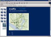
An interactive Web site provides real-time information to travelers on road conditions and parking availablity. |
|
The information used to advise travelers can be accumulated and studied to make better policy decisions about transportation. This system also promotes the use of alternate methods of transportation such as buses and bicycles.
Real-Time Data
Though the initial implementation was based on ArcInfo, ROMANSE now uses ArcView GIS and Siemens' Urban Traffic Control (UTC) system. Esri (UK) developed an ArcView GIS extension, Strategic Information System Client, that displays an overview of transport environment using information from the UTC system. Various types of transport data are displayed as themes in ArcView GIS.
The basemap used for the system originated from the United Kingdom's Ordnance Survey. Road network condition data is displayed against this base. Data is collected from a variety of sources. Closed-circuit television (CCTV) is installed in 30 key locations in and around Southampton to monitor traffic.
Operators can pan, tile, and zoom cameras. Automated Road Traffic Event Monitoring Information System (ARTEMIS) software constantly scans the CCTV pictures to gather and process information on traffic flows, average speeds, and incidents. Additional data from roadside detectors and global positioning system (GPS) units on buses along with the CCTV-derived information is fed into the UTC system. It is then processed and integrated by ArcView GIS and displayed at the Traffic and Travel Information Centre (TTIC) in Quay, Southampton.
Effective Strategies
Instead of trying to interpret text-based data, TTIC staff can quickly assess the current state of the road network by looking at maps created by ArcView GIS. TTIC staff use the information to analyze existing conditions and spot developing problems as well as to dispatch emergency services. Information on traffic flow per minute, traffic speeds, congestion, and car park occupancy can be immediately transmitted to travelers via a system of variable message roadside signs and radio broadcasts.
Free-standing computer terminals, located at transportation, shopping, and tourist information centers, supply information on public transport routes and times, help route car trips, and provide information for tourists on hotel accommodations and points of interest. Bus stops feature screen displays that show the arrival times of buses calculated from updated information on bus location obtained from GPS units on the buses.
An interactive Web site that provides real-time information on road conditions also allows users to check the current and
|
"ROMANSE is one of the most advanced traffic control systems in the UK." |
predicted occupancy in car parks before traveling, includes an application that helps users plan trips using the public transit system, and contains information about cycling. MapObjects Internet Map Server (IMS) software provides current traffic information through maps created on demand by visitors to the ROMANSE Web site. Users can customize how the various modules are displayed when they visit the site.
"ROMANSE is one of the most advanced traffic control systems in the UK. By putting this detailed integrated information on the Internet, it is now at the leading edge of traffic and public transport information systems throughout Europe, " says Jim Stembridge, GIS project manager for the Hampshire County Council.
System Integration Is the Key Element
The high level of system integration made possible through GIS is one of the unique features of ROMANSE. The various aspects of the projectdata collection from many sources; analysis using the Strategic Information System Client; dissemination of transport network information to the public via signage, information screens, radio, and the Internet; and the use of that information in decision making and planningwork together to minimize congestion and make the best use of resources.
ROMANSE was recognized in 1995 with an award from the British Computer Society (BCS) for Innovative IT projects. BCS IT awards are given not only for excellence in computing, but on the basis of the social benefit and business value to society created by the project.
The system has moved rapidly from a concept in 1992 to a fully operational system that has met with positive response from the public. Current plans call for delivery of working systems that can be marketed commercially to other cities throughout the world. This comprehensive GIS-based traffic control and travel information system can be used to alleviate traffic problems by helping the public more efficiently use the existing transport infrastructure and improve policy decisions on transportation issues in the future.
For more information, please contact Alan Ross at Esri (UK).
|