October - December 2003
October - December 2003 |
||||||||
|
|
||||||||
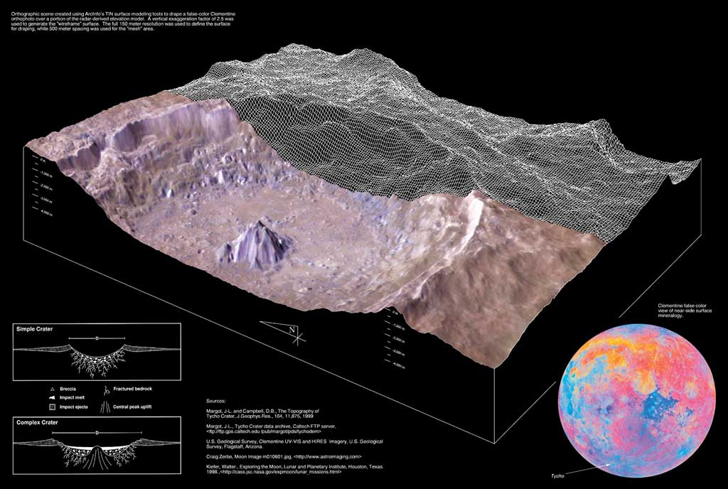
The crater Tycho is one of the most visually striking features on the moon's near side. The youngest large crater visible from earth, Tycho is located south of Mare Nubium (Sea of Clouds) in the moon's heavily cratered southern highlands. Tycho has a diameter of 85 kilometers or 53 miles. Average depth below the rim is 4,700 meters and a central peak rises 2,400 meters above the crater floor. Tycho was formed about 100 million years ago when a large meteorite or comet collided with the earth's moon. The resulting explosion vaporized vast quantities of the surrounding lunar surface and sent a large amount of debris in a plume high above the moon. The intense heat generated by the impact melted rock that splashed out of the crater, forming an apron of melted material that extended up to one crater diameter away from Tycho's outer rim. Large debris fragments on ballistic trajectories created numerous secondary impact craters in the immediate vicinity of the primary crater. Lighter material was thrown higher and deposited in rays of fallout. One of these rays crosses the landing site of Apollo 17, which is more than 2,000 kilometers from the crater. It is believed that landslides on mountain slopes surrounding the Apollo 17 site were triggered by falling Tycho ejecta according to work by California Institute of Technology staff scientist Walter Kiefer. The extent of this fallout zone around Tycho is dramatically portrayed on the global false-color image from Clementine. The impacting body penetrated deep into the moon's crust, dredging up rocks of different composition than those found at the surface. This "exotic" material can be seen in the three-dimensional view as the blue formation on the crater floor and especially the central peak. Research published by J.-L. Margot, D.B. Campbell, R.F. Jurgens, and M.A. Slade indicates that the 200-meter elevation difference between eastern and western halves of the crater floor, coupled with variations in slumping along portions of the wall, shows that the trajectory for the impacting body might have been oblique. ReferencesMargot, J.-L., D.B. Campbell, R.F. Jurgens, andM.A. Slade, "The Topography of TychoCrater," Journal of Geophysical Research-Planets, 104, E5, pages 11875-11882, May 1999. Margot, J.-L., Tycho, Crater Data Archive, CaltechFTP Server, ftp://ftp.gps.caltech.edu/pub/margot/pds/tychodem. U.S. Geological Survey, Clementine UV-VISand HIRES Imagery, U.S. Geological Survey, Flagstaff, Arizona. Zerbe, Craig, Moon Image m010601.jpg, www.astroimaging.com. Kiefer, Walter, Exploring the Moon, Lunar and Planetary Institute, Houston, Texas, 1998, cass.jsc.nasa.gov/expmoon/lunar_missions.html (page not available 9-4-2003). Collection of Outstanding MapsEvery year since 1984, the Esri Map Book has acknowledged the exemplary work of GIS professionals. Volume 18: Geography and GIS—Serving Our World is the newest collection of maps produced by Esri GIS users. More than 20 disciplines are represented. These maps were created to meet diverse needs—from assessing the influence of air pollution levels on asthma to determining the correct direction to face when praying to Mecca. More than 100 maps, printed in full color, are accompanied by descriptions of the maps' use and creation. Order a copy of the latest Esri Map Book online at www.esri.com/shop. |