A Field by Any Other Name
English / Spanish
 The Show Aliases command in the table window Options menu lets you decide whether to display field names or aliases. | |
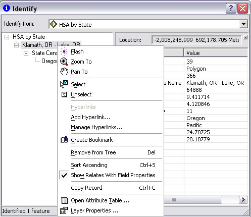 In the Identify dialog box, simply right-click the feature identified and choose Show Relates with Field Properties from the context menu. | |
 To access related data while using the Identify tool, the related layer or table must be present in the map document. |
ArcGIS 9.3 works more effectively with field aliases. Aliases let you assign more meaningful names to fields. This is helpful for labeling and manipulating tables. You can now toggle between actual and aliased field names, preserve aliases when you join tables, and show field aliases and related data when using the Identify tool.
New commands and keyboard shortcuts let you quickly toggle between showing field aliases or actual field names. The Show Aliases command in the table window Options menu lets you decide whether to display field names or aliases. This property is set for each table individually. By default, the Options menu choice to enable aliases is checked. There are also two shortcuts for toggling between field aliases and field names: hold down Ctrl and right-click the field name or select the field and press Ctrl+Shift+N.
Field properties, including field aliases, are retained when you join tables or create definition queries on joined tables. Previously, field properties, such as field aliases and numeric settings, were dropped when table joins were created or removed. Now, field properties are also preserved when you remove a definition query from a layer or stand-alone table that contains a join.
A new command lets you choose whether to display related data in the Identify dialog box. This command is available in the ArcMap application of ArcGIS Desktop, in the ArcGlobe application of ArcGIS 3D Analyst, in ArcReader, and in applications developed with ArcGIS Engine. In the Identify dialog box, simply right-click the feature identified and choose Show Relates with Field Properties from the context menu. By default, this option is turned on. To access related data while using the Identify tool, the related layer or table must be present in the map document. Also, definition queries in the table or layer that is the source for related data are not respected by the Identify tool whether or not Show Relates has been enabled.
This new functionality makes aliases easier and more powerful to work with when accessing information in table fields.