GIS Aids in Search for Man Lost in California's Rugged San Bernardino Mountains
By Tom Patterson, Esri Wildland Fire Specialist
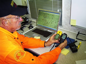
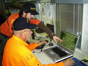 GPS Technical Specialist Rich Dexter (seated), a search and rescue volunteer for the San Bernardino County Sheriff's Department's Mobile Mapping Unit, displays search data collected by field team members such as Kevin Murphy (standing). |
Green Valley Lake, California—During a visit to his vacation home in this small community in the San Bernardino Mountains east of Los Angeles, retired educator Dean Christy decided to go out for a hike in the crisp winter air.
But soon after he ventured out into the rugged terrain, a storm moved into the area. Hours later, at 4:15 p.m., January 4, 2008, Christy, 62, placed a 911 call using his cell phone, reporting that he was disoriented due to limited visibility in dense fog.
Search and rescue (SAR) teams were hastily dispatched to look for the missing hiker. As the hours stretched into days with no success in finding Christy, the San Bernardino County Sheriff's Department (SBSO) Mobile Mapping Unit joined the operation to produce a variety of maps to assist in the search. The Mobile Mapping Unit created the maps using geographic information system (GIS) technology. The maps helped determine where to concentrate the search for Christy, pinpoint the areas that had already been covered by searchers to avoid retracing the same routes, and brief Christy's family about the progress of the search. To try and narrow the search areas, GIS was also used to conduct a viewshed analysis of the zone where Christy likely used his cell phone.
"The benefit to having on-site mapping is that we can use downloaded data provided by searchers from the current day to prepare for the next operational period," said incident commander Cpl. Bryan Lane of SBSO. "In the case of a search and rescue, we use the maps to analyze areas physically covered by personnel in the field and then to direct resources into areas not searched yet."
Searchers Faced Wretched Conditions
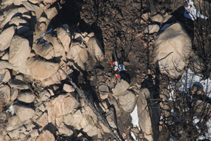 Searchers comb the rock outcroppings near Green Valley Lake in the San Bernardino Mountains looking for missing hiker Dean Christy. Photo courtesy of John Amrhein/San Bernardino County Sheriff's Department. |
The first SAR team to reach Green Valley Lake to search for Christy was the Rim of the World Search and Rescue Team. They arrived at about 6:30 p.m., January 4, near the Green Valley Lake campground, which is located approximately one-eighth of a mile east of the Christy home. They were greeted by freezing rain and heavy winds gusting up to 90 miles per hour. Confinement and attraction tactics were used throughout the night including emergency vehicle lights, sirens, and public address systems.
During the initial call, Christy told the 911 dispatcher that he was dressed warmly and was prepared to stay outside by taking shelter under a rock outcropping located about 50 feet from where he was making the call. That was the last time anyone heard from him. (At about 1:00 a.m., January 5, Christy attempted to make a cellular call to access his voice mail. The call was not completed, and that was the last time Christy used his phone.)
At about 2:00 p.m., January 5, the rain turned into a blizzard that continued until early January 7, dumping up to six feet of snow in the primary search area.
During the next eight days, SAR teams from all over Southern California and as far north as Lake Tahoe and the San Francisco Bay Area joined in the search. Helicopters and snowcats brought searchers and their equipment into the field. When aviation assets weren't being used for shuttling searchers into the area, field observers would fly during the day when weather permitted, and at night, the helicopters were equipped with forward-looking infrared (FLIR) sensors and the pilots wore night-vision goggles that can detect aboveground body heat.
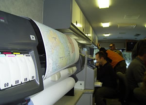 The San Bernardino County Sheriff's Department's Mobile Mapping Unit produced GIS maps for the search and rescue operation. The 40-foot custom motorhome contains a wide-format plotter, color copier, and GIS workstations. |
The Incident Command System (ICS) was used to manage this massive rescue operation; approximately 100 searchers were assigned each day. Many of the visiting teams from outside the local area commented favorably on how well organized this search was.
Data Downloaded to Create Maps
When the search for Christy expanded to 30 square miles on January 10, Lane decided to increase the on-scene map production capability by bringing in SBSO's Mobile Mapping Unit. This 40-foot custom motorhome contains a generator, two networked GIS workstations, a color copy machine, remote satellite access to the Internet, and a large-format Hewlett-Packard plotter for making 36" x 44" briefing maps. Sheriff's Department personnel staff the Mobile Mapping Unit. The members include a situation unit leader, a GPS technical specialist, and two public information officers. Two additional GIS technical specialists from Esri joined the team. They all worked comfortably within the confines of the heated vehicle during the 12- to 16 hour shifts. This arrangement made for a smooth workflow in which search and rescue teams would bring their GPS receivers, used to document their area searched, to the Mobile Mapping Unit at the end of the shift.
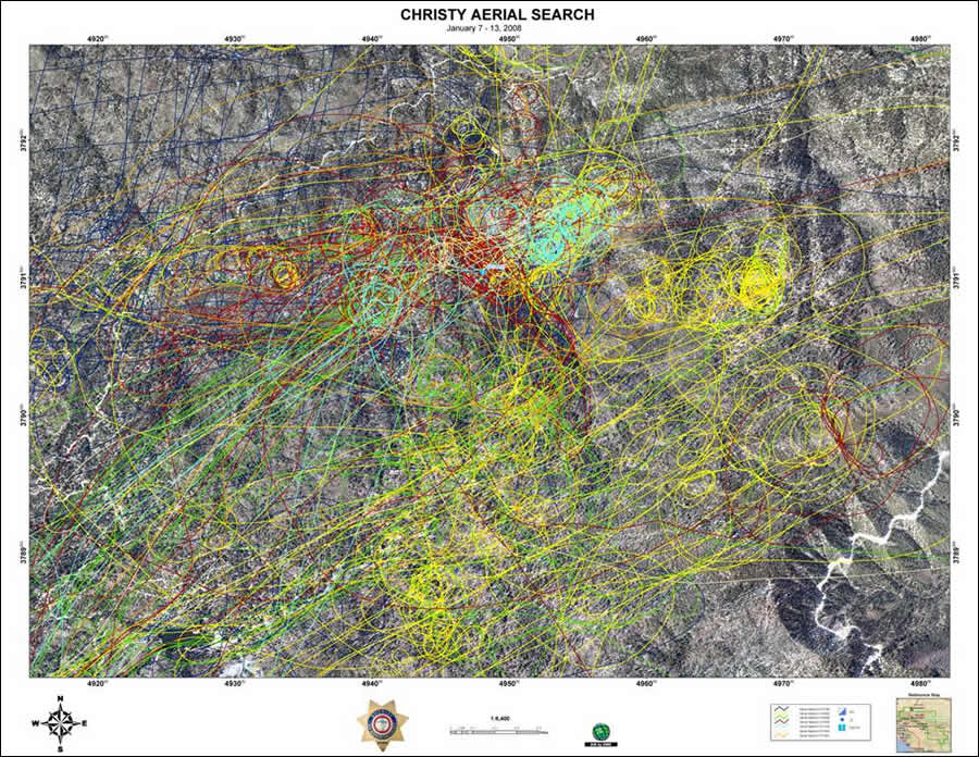 GPS data was downloaded from the AeroComputers Tactical Mapping System from each of the helicopters and displayed in ArcGIS. The information helped determine which areas were adequately searched and which ones needed to be revisited. Aerial imagery courtesy DigitalGlobe. |
While the teams searched their assigned areas, their progress was recorded on handheld GPS receivers. Waypoints depicting the coordinates of any clues found, such as tracks, discarded food wrappers, or items of clothing, were also recorded into the devices. At the end of the shift, these track logs were downloaded and converted into shapefile format by the GPS technical specialist using Maptech's Terrain Navigator Pro software.
Maptech is an Esri business partner, and its mapping program is popular with many SAR teams and fire departments. It easily displayed and exported GPS track logs collected by the teams and converted them into a single shapefile. With Esri's ArcInfo software, staff could then use the single shapefile to create a comprehensive search history and incident action plan maps. As the last team went through the debriefing process, it took little time to display an overall picture of the entire day's activities, which were also overlaid with previous operational periods. Search managers could tell at a glance where to deploy resources for the next day. GPS data was also downloaded from the AeroComputers Tactical Mapping System from each of the helicopters and displayed in ArcGIS. These aerial layers could be easily combined with the ground team's data to enhance the decisions being made for the next operational period. For example, the information helped determine which areas were adequately searched and which ones needed to be revisited.
"Additionally, having a full map set with GPS track logs to put into the case file helps us direct future operations in the area and to document a higher standard of care," Lane said.
Viewshed Analysis Conducted
GIS was also used to attempt to pinpoint potential areas where Christy might have made his last 911 call.
The California Highway Patrol's 911 dispatch center provided the coordinates of that location. The accuracy of that point was +/- 550 meters, and officials were convinced that it went through the Strawberry Peak cell site, 10.8 air miles away to the east in Rim Forest.
Esri's ArcGIS Spatial Analyst extension was used to perform a viewshed analysis of all the areas within a 1,000 meter circumference surrounding the location where he placed the call that had a line of sight to the Strawberry Peak cell tower. Searchers made cellular phone calls from random locations in the zone identified as the one from which Christy called for help. The calls made within the shaded areas were able to connect with the 911 dispatcher through Strawberry Peak; those outside the orange polygons on the map either couldn't connect or else connected through cell towers on the Victorville side of the mountain. This map, along with the search history maps, was used to brief Christy's family and help incident commanders make an informed decision to scale back the operation on the afternoon of January 13.
Diligent Searchers Find Body
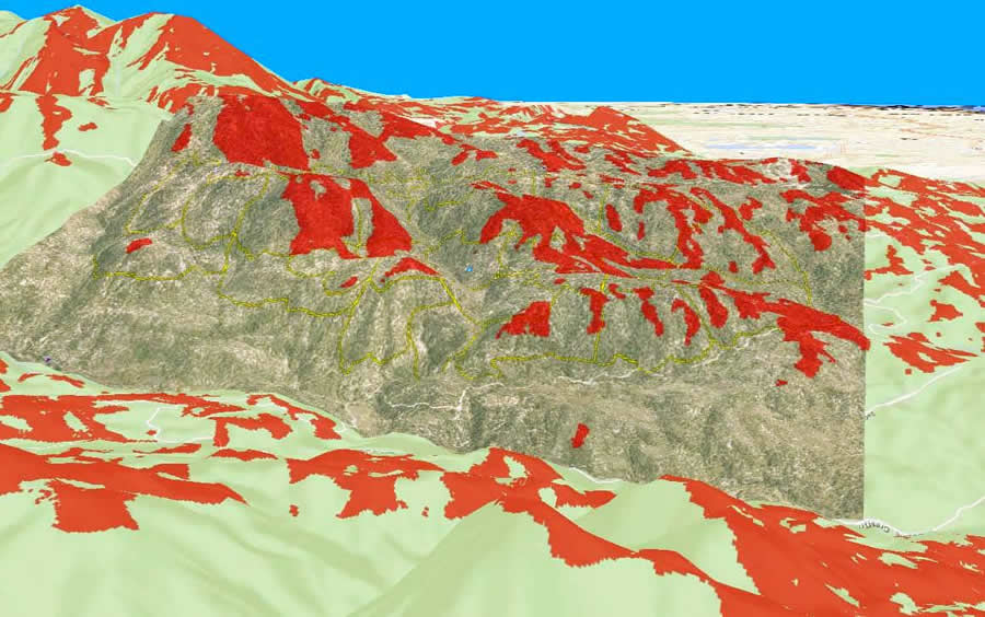 The yellow lines in this GIS viewshed analysis denote the search area boundaries. Officials believe Dean Christy's 911 call originated from within those boundaries. The dark orange polygons show the areas within the line of sight of Strawberry Peak and its cell phone tower. Searchers made cellular phone calls from random locations in the zone identified as the one from which Christy called for help. The calls made within shaded areas were able to connect with the 911 dispatcher through Strawberry Peak; those outside the dark orange polygons on the map either couldn't connect or else connected through cell towers on the Victorville side of the mountain. |
However, the search remained active. On April 4-three months to the day since he went missing-the Rim of the World Search and Rescue Team found Christy's body northeast of Green Valley Lake, less than 1.5 miles from his home.
"On trails, he had traveled approximately 3.5 miles," said Lane from SBSO. "He sheltered between a rock and a large tree. It appears there may have been some branches on the rocks above him he may have used to protect himself."
Christy was located in a rock outcropping in an area identified in the viewshed analysis as having line of sight to the Strawberry Peak cell tower.
"It was in an area that had been searched more than once, but he was probably covered with snow when searchers were there before," said Donna Newlin, commander of the Rim of the World Search and Rescue Team.
The team continued to conduct regular searches for Christy after the major operation had been scaled back. "We did something called a Mattson Consensus," Newlin said. "We gather all the available information and clues and ask as many experienced searchers as possible to circle areas on the map that they think he would be in. Based on the cell phone 'hit,' the clues he left verbally on the 911 tapes, and the terrain, we had consensus-the group's combined gut feeling. The team had been slowly and methodically clearing snow-free areas and mapping our progress. We filled in places on the map where we could now say, with a higher degree of confidence, where he was not. The team finally got into the right area, and instead of knowing where he was not, we finally knew where he was. The GIS analysis of the cell phone hits definitely impacted our decision on which areas to focus on. I am just glad the family has some answers now."
SAR Teams Embrace Newer Technology
The use of geospatial technologies has gained wider acceptance by the search and rescue community in the last five years.
Today's search and rescue teams are more aware of the capabilities GIS can provide in the saving and safeguarding of human life. Only half the teams were equipped with GPS receivers during the search for Marvin Matsumoto in April 2003. Every SAR team member now carries a GPS device that can be purchased for as little as $99. Working from the front seat of a patrol car with a vehicle mounted laptop during the five-day search for Matsumoto was far more arduous than working inside SBSO's Mobile Mapping Unit during the search for Christy. Internet connectivity from remote areas was either nonexistent or extremely slow in 2003.
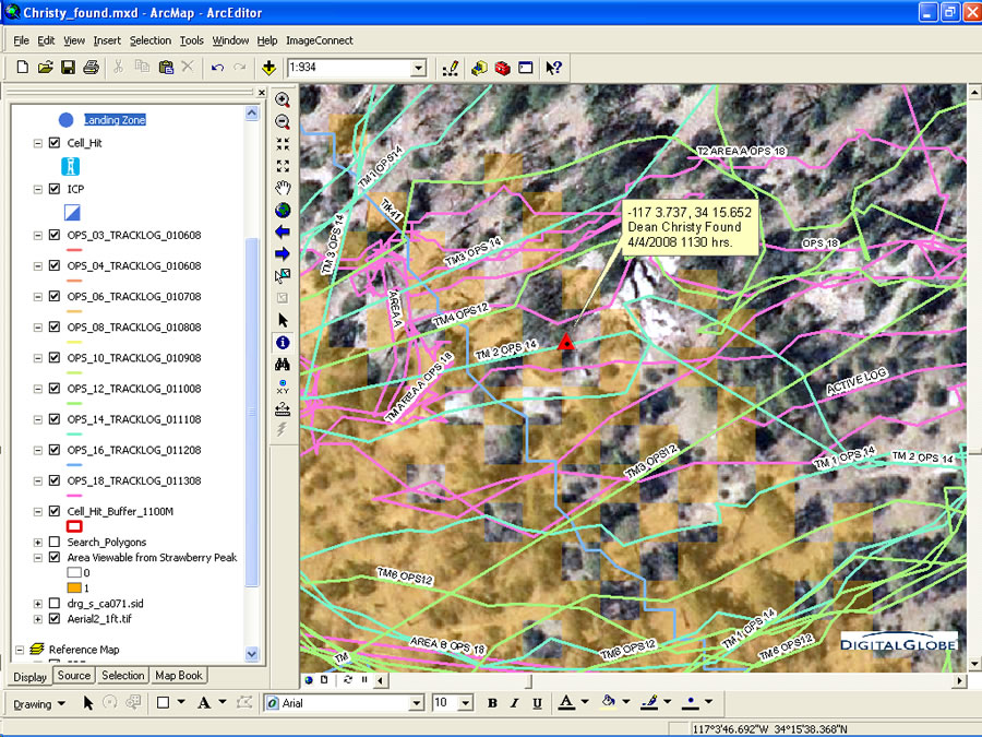 The Rim of the World Search and Rescue Team provided these coordinates of where Dean Christy's body was found. The coordinates were then added to the search history GIS display. The orange shaded areas indicate line of sight to the Strawberry Peak cell tower. The colored lines represent GPS track logs from search teams. Christy's body was discovered in a location where searchers thought there was a high probability of him being found based on his cell phone calls. Searchers had previously covered the area but he was buried under several feet of snow during that time. |
The 2008 search used a server that accessed a satellite broadband connection to retrieve ArcGIS Explorer 3D visualization enhancements. It was easy to overlay the polyline shapefiles created from the GPS track logs and display them in ArcGIS Explorer to create a 3D map. Aerial imagery or topographic map data was displayed as a background and draped over digital elevation models. Roads and administrative boundaries could be added for reference. This gave a true representation of the terrain difficulty, which was much easier for field teams to understand than a two-dimensional topographic map with contour lines. SBSO personnel were especially impressed that all this information is available for the entire country and can be accessed through the freely downloadable ArcGIS Explorer application.
Today, companies produce easy-to-learn GIS software programs designed specifically for search and rescue applications. One of the more intuitive applications is made by RedZone Software. RZ3 is built on Esri technology and has full editing capabilities. The total time needed to learn this skill is less than four hours including field exercises.
During the search for Christy, a rugged, external GPS-enabled radio speaker/microphone was tested. It is an effective tool to enhance situational awareness and increase field personnel safety. Every time an SAR team member keys the radio to send a message, data consisting of coordinates, speed, heading, altitude, and personal identity is transmitted. The device can also be programmed to automatically transmit at a specified time interval; i.e., every 2 minutes for ground teams and every 10 seconds for flight following of helicopters. In addition, the microphone has a sunlight-readable display that shows the user's location and the location of and distance from all other team members on the same frequency. Another useful enhancement is the ability to send text messages over a radio frequency and read them from the microphone's display. From the incident command post or any command vehicle within radio range, search managers can keep track of all SAR personnel, aircraft, canine units, snowcats, and other resources in real time just by looking at their laptop screen running RedZone software. This frees up the radio frequencies for essential transmissions and takes the guesswork out of trying to determine personnel location either day or night. In the very near future, search teams returning to the incident command post will see their track logs already displayed in the Mobile Mapping Unit, and maps of their search progress will be printed and waiting for their approval.
GIS is now widely recognized as an essential tool for making faster, safer, and more informed decisions. This is particularly useful in search and rescue, where so much is at stake. Sometimes intense search operations are not successful in finding lost individuals in the wilderness.
One of the most important advantages of using GIS in SAR missions, and one that pleases the risk managers, is thorough documentation. These maps would make great exhibits during any litigation that may arise from a search.
 Rich Dexter holds a GPS-enabled radio speaker/microphone (right) next to a commercial recreation-grade receiver. |
"There's no doubt that GIS has become an important tool for search managers," said John Amrhein, SBSO's Situation Unit leader. "GIS allows us to make better-informed decisions on where to concentrate searchers in the following operational periods. Being able to know exactly where a team has searched is invaluable, whereas in the past you would just have the teams' best guess as to what areas they had covered. I am also very excited about the possibilities of the new technology of live tracking search assets in the field, not only from a search management view but for searcher safety issues. Also, as in any operation, documentation is important, and GIS provides this very nicely."
For more information about the San Bernardino County Sheriff's Department Mobile Mapping Unit, GIS for Search and Rescue training course, and real-time GIS rescue applications, contact John Amrhein at jamrhein@sbcsd.org, Tom Patterson at tpatterson@esri.com, or Clark Woodward at cwoodward@redzonesoftware.com.