ArcGIS Image Server: A Fast and Cost-Effective Way to Quickly Deliver Imagery to Customers
For organizations such as the U.S. Forest Service and the natural gas delivery company CenterPoint Energy, Esri's ArcGIS Image Server solved a once-constant challenge: the processing and delivery of large amounts of imagery to many users in a timely manner. By using ArcGIS Image Server, government agencies and commercial businesses can process, manage, and deliver imagery faster than ever before.
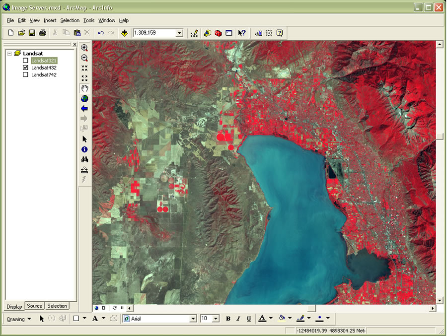
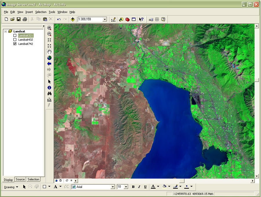
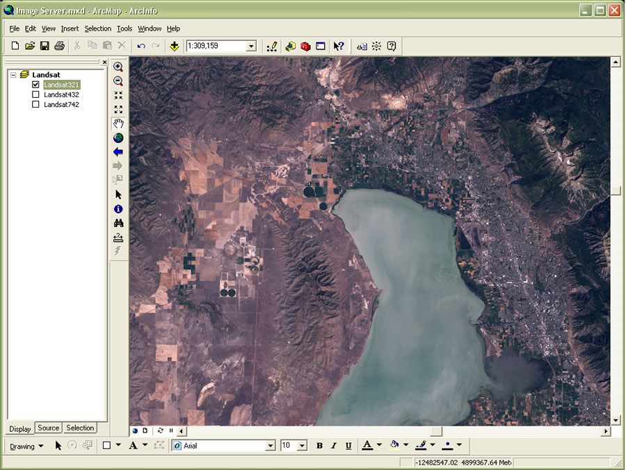 Three different represen-tations of Landsat imagery served directly by ArcGIS Image Server. | |
 |
|
 |
The software provides quick access to and visualization of large quantities of imagery, processed on the fly and on demand. Image processing is performed by the server as requested by clients, eliminating the need to preprocess the imagery after capture. This gives users immediate access to the imagery once it is acquired. When a client makes a request, ArcGIS Image Server processes the imagery and delivers it, along with important metadata, to the client almost instantaneously.
That fast delivery fit the requirements of CenterPoint Energy, the third largest publicly traded natural gas delivery company in the United States, which began using ArcGIS Image Server in late 2006. The company's application was configured to support mission-critical needs in case a large-scale natural disaster, such as a hurricane, disrupted service to its customers. CenterPoint Energy required a solution that would deliver high-quality image data of the impacted area and damaged assets immediately after such a disaster.
"We set ambitious goals for using our imagery data, and we needed fast processing times to meet the demands we set up for ourselves," says Cynthia Salas, GIS manager for CenterPoint Energy. "When we tested ArcGIS Image Server, we found designers, technicians, and digitizers were all very pleased with the processing time. It was twice as fast—in some cases even faster—than previously. And they were impressed with the resolution. It was much better. This is the first time since I've been here that we tested a new technology and had staff come to us requesting that we immediately go into full production."
Advantages of ArcGIS Image Server
ArcGIS Image Server is an enterprise product that uniquely combines image distribution and on-the-fly, server-based image processing. Because ArcGIS Image Server handles image processing for each client request, users are only required to store source imagery. That eliminates the need to maintain multiple sets of processed imagery. As users update and refine their data, changes are immediately reflected and delivered to clients, reducing maintenance costs. And with only a single set of images to maintain, users enjoy substantially reduced storage requirements.
ArcGIS Image Server provides a wide range of processing options that give users all the benefits of processed imagery without extra cost. By supporting leading third-party client applications—including applications from Autodesk and Bentley—ArcGIS Image Server allows users to leverage imagery within familiar applications.
The Value of ArcGIS Image Server
ArcGIS Image Server provides value to any organization that has large amounts of imagery to be consumed by numerous users inside or outside the organization. By reducing the data storage costs and manpower required for image processing, maintenance, and distribution, ArcGIS Image Server provides an instant return on investment. Besides on-the-fly image processing and fast access to geospatial imagery, the immediate value of ArcGIS Image Server is also derived from
- Data and client interoperability: ArcGIS Image Server provides access to multiple image file formats from multiple clients, eliminating the need to convert source data into proprietary formats.
- Full scalability: ArcGIS Image Server can scale to meet current and future technical and functional requirements.
The Growing Need for Better Access to Imagery
Imagery is important for many applications and has many uses including
- Providing a natural background in many GIS applications, where it's often used to assist navigation. The popularity of sites such as Google Earth has increased users' demand to see imagery as a backdrop to their applications.
- For direct interpretation, where the user looks at the imagery to identify features.
- As the source used for digitizing the vector maps that are the basis of most GIS systems.
- For the verification of vector data. When questions arise about the reliability of vector data used in an analysis, often more up-to-date imagery is available, which can be used to check the vector data.
Not all uses of imagery are the same. Therefore, different applications require different types of imagery that can be optimized for specific applications. For some applications, timeliness is most important; for others, it is quality or the sun angle, and so on.
Fast, Dynamic Image Processing and Distribution
Traditionally, image processing and distribution have been considered as two separate stages in image exploitation. This separation causes data redundancy, radically increases volumes of data, and hinders efficient data management. With ArcGIS Image Server, these two stages are combined, enabling administrators to maintain only the primary imagery with multiple image products created on the fly as required by users. This is a significant and unique paradigm shift for how imagery is managed, processed, and distributed, which resolves many issues pertaining to imagery.
Imagery can be quickly published using the best available processing parameters, and over time the grade of the product can be increased as better georeferencing or enhancement parameters become available. This methodology, when applied to imagery, reduces the latency between image capture and usage, thereby maximizing the value of imagery and making it easier to maintain. Even data backup is substantially simplified as volumes of pixel data need only be backed up once. The parameters that define the processing to be performed are small, and this can be done very easily.
ArcGIS Image Server is able to generate multiple image products from a single data source, each with different radiometric processing, geometric processing, and compression options. This on-the-fly processing maximizes the depth of information within the imagery. ArcGIS Image Server thereby enables users to eliminate data management problems associated with multiple preprocessed datasets and can substantially reduce data storage requirements. Server-side processing also enables access to raster data from thin client applications, reducing requirements for workstations to access and process the data.
The distribution and processing capabilities of ArcGIS Image Server include
- Direct support of multiple file formats and compressions
- Multiplatform GIS, CAD, imaging, and Web access
- Extensive service and image metadata support
- Access to information from overlapping imagery
- Independence from third-party software or a DBMS
- Data security and access logging
The benefits of using ArcGIS Image Server over traditional methods of image data management include
- Extensive coordinate transformation capability—It resolves many issues that occur with imagery in different spatial reference systems.
- Handles disparate datasets—Data is often not in the form of well-defined, rectangular blocks but is spread among different areas of interest such as along roads. Traditional systems that require a single image format or size cannot handle such cases.
- Scalable to massive amounts of imagery and large numbers of users—It's easy to get the system up and running and expand it as data or the number of users increases.
- Integration—It can be integrated into existing infrastructures by leveraging the plug-ins to other applications and using the Web standards support of ArcGIS Server to deliver the imagery.
Many Applications for ArcGIS Image Server
The United States Department of Agriculture's (USDA) Forest Service Remote Sensing Applications Center (RSAC) in Salt Lake City, Utah, is now using ArcGIS Image Server to quickly deliver vast amounts of imagery throughout its organization via an intranet. Before the implementation, the Forest Service struggled to make large volumes of imagery available to staff in its nine regions across the 50 states. Users often had difficulty loading the imagery due to limited storage capacity.
"We were looking for something that would move us up to an enterprise-level imagery management system," says Mike Morrison, training and technology awareness program leader for RSAC and manager of image software program deployment for the Forest Service. "We wanted to resolve storage management problems and be able to very quickly stream imagery to field offices. That's when we started looking at ArcGIS Image Server."
ArcGIS Image Server enables users to utilize the value of new raster datasets for a range of applications such as
- Emergency response and planning for security and military operations, which need fast access to huge raster datasets after acquisition. During emergencies, people need quick access to information. ArcGIS Image Server allows users to take the acquired image data and make it available online in a timely manner as georeferenced data. Additionally, users can update the service with new imagery as it becomes available or update the georeferencing or radiometric processing as better parameters are determined.
- Municipalities and utilities, where a large number of users need access to different imagery from different applications. Many municipalities often provide public access to their imagery as orthorectified datasets while also requiring a higher-resolution version for use in their own planning departments. ArcGIS Image Server allows users to use the same data for both and provides the ability to restrict public access to a coarser resolution.
- Data acquisition and provisioning organizations, which need to manage, process, and distribute huge quantities of imagery. Such organizations may need to keep catalogs of a large number of images, provide access to subsets of the images as services, and quickly create products for distribution. With ArcGIS Image Server, not only can the user easily manage large quantities of image data and their attributes, but the required products can be defined as dynamic services available for timely access or processed to a product for conventional distribution.
- Environmental organizations, which need to process, manage, and compare many different types of imagery. In environmental applications, requirements often exist to handle many different data sources with different dates, spectral characteristics, and resolutions. With ArcGIS Image Server, such imagery can be accessed as multiple services for viewing in a GIS or in other applications.
Learn more about how ArcGIS Image Server helps customers by reading ArcGIS Image Server Speeds Enterprise Imagery Distribution and Processing at CenterPoint Energy.