Fall 2004
Fall 2004 |
|||||||
|
|
|||||||
Coral Communities in Hawaii Mapped With GIS and Geospatial Video |
|||||||
The world's coral reefs provide sanctuary and nutrition to hundreds of thousands of marine species. Although they cover less than 1 percent of the earth's surface, reef habitats support an estimated 25 percent of all marine species. This incredible biodiversity in such a concentrated geographic area has earned coral reefs the nickname "rain forests of the sea." Unfortunately they share another characteristic with rain forests: due primarily to human activity, coral reefs are deteriorating worldwide and many are in crisis. In the last few decades more than 35 million acres of reef have been lost, and it is estimated that 30 percent of the world's reefs will be destroyed or seriously degraded in the next 10 years. This issue has received broad recognition and international efforts are underway to reverse the trend. The United States is one of many nations around the world working to halt the coral reef crisis and restore and protect coral reef ecosystems for sustainable use by current and future generations. By presidential order, the U.S. Coral Reef Task Force (CRTF) was established in June 1998. CRTF is responsible for developing and implementing coordinated efforts to
As a member of CRTF, the U.S. Geological Survey (USGS), working closely with academic institutions and state and other federal agencies, is spearheading an effort to better understand the processes that affect the health and sustainability of coral reefs. GIS plays a critical role in this work. Benthic (underwater) habitat maps are being developed with the objectives of
These baseline digital maps and databases are needed to detect and understand changes in the reef environment over time.
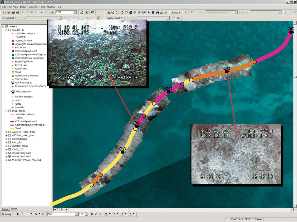
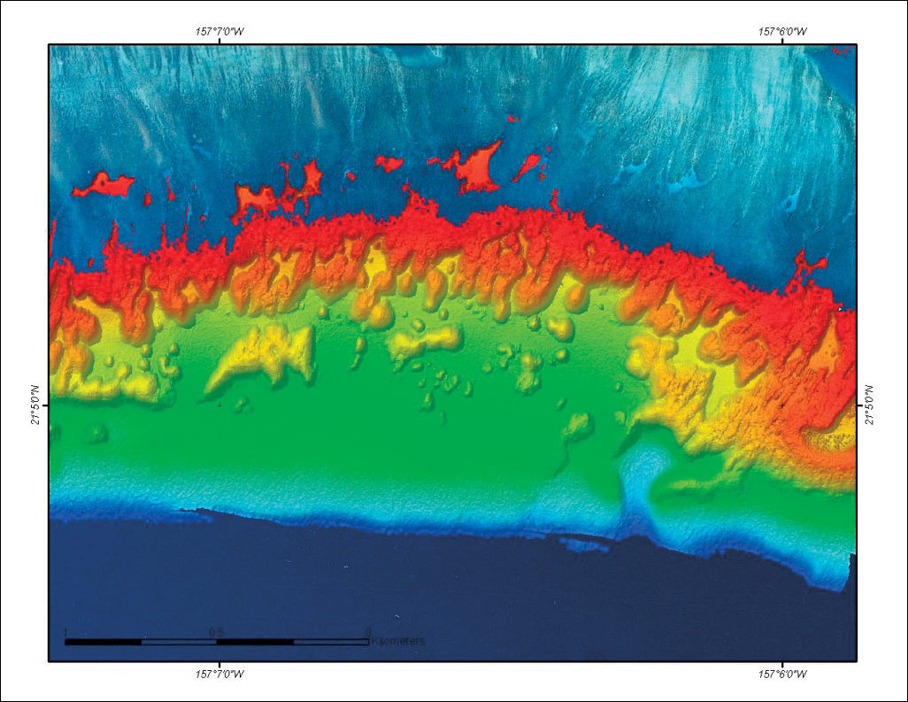
Several of the USGS study sites are located in the Hawaiian Islands. There, reef habitats are studied using a variety of tools and techniques. Remotely sensed data from several different sources is being analyzed to determine its capacity for detecting and mapping the location of live and dead reef areas, density and type of coral cover, algae, silt, and sand. According to Ann Gibbs, a geologist with USGS, "High-resolution aerial imagery provides the basis for mapping shallow-water structures and features of the coral reefs. Aerial photography provides an excellent overview of reef habitats because of the typically clear, shallow water." Aerial photography is relatively inexpensive and with proper planning can allow for optimum conditions (sun angle, cloud cover) during image acquisition. The major problem with using aerial photography is lack of light penetration in deeper water. In depths greater than 20 to 25 meters, its usefulness is limited as a source of information on seabed conditions. Light detection and ranging (LIDAR) technology uses lasers to produce high-resolution seabed bathymetry maps. Although more expensive than aerial photography, the Scanning Hydrographic Operational Airborne LIDAR Survey (SHOALS) system collects bathymetric data, which reveals topographic details of reef structure and morphology that are not available from aerial photographs. LIDAR also has the advantage of providing information from water depths of more than 40 meters, depending on water clarity. Aerial photography and LIDAR fall into the category of broad-scale remote sensing, which provides general information over a relatively wide geographic range. Broad-scale remote sensing by itself has been found to be only partially capable of providing the information necessary to produce accurate habitat maps. In cases in which it can be collected, the data must be corroborated (ground-truthed) by in situ measurements of coral cover. In deeper water other techniques must be utilized, since coral reef communities in Hawaii can extend to depths beyond 40 meters. Recently, USGS achieved satisfactory results augmenting the broad-scale remotely sensed data with geospatial video of the seabed, a fine-scale remote sensing technique. Fine-scale remote sensing allows researchers to make more detailed observations over smaller sections of the seabed. According to Gibbs, "Geospatial video using an underwater video camera allows us to actually see what is on the seabed with the added advantage of being able to gather information from depths where our other remote sensing methods can't penetrate."
Geospatial video is video that has been encoded with GPS positional information at the time of capture in such a way that the GIS system can display a track line indicating the path of travel of the camera and provide map-centric access to the video and audio content. During playback, a moving cursor on the map maintains a geospatial reference to position and direction of the camera. Red Hen Systems, an Esri Business Partner, has been delivering geospatial video solutions since 1997. USGS chose Red Hen Systems because the firm could deliver a complete processing package, including field collection tools and mapping software compatible with ArcGIS Desktop. The company's latest product, GeoVideo, an extension to Esri's ArcGIS Desktop, provides users with the ability to index and control playback of the geospatially referenced video from inside an ArcGIS project. To collect the geospatial video, USGS tows an underwater video camera over the seabed following a preplanned grid pattern. Red Hen Systems Video Mapping System encodes the video with GPS data at collection time. The collection system allows for viewing of the video data in real time while it's being recorded. The system also indicates the vessel's location and trails of previously captured video within the mapped environment. Back on shore the georeferenced imagery of the seabed is reviewed and interpreted using ArcInfo and GeoVideo. USGS uses ArcInfo because it has the ability to organize and work with layers of remotely sensed data and convert them to georeferenced database features representing the benthic habitat. Line segments are created in ArcInfo and attributed based on the parameters of interest (seabed type, density of coral, etc.). "It's at this point that the geospatial video allows us to answer the question, 'What does the seabed look like right there?'," explains Gibbs. The attributed line segments are then integrated with the bathymetry and aerial photography, resulting in a thematic map that accurately represents coral reef conditions in the area of interest. USGS employs a laptop computer with a 2 GHz Pentium processor and 524 MB of RAM to host the system. This configuration is used on the research vessel during video collection and in the office during postanalysis and mapping in ArcGIS Desktop (ArcInfo) software's ArcMap application. For more information on the USGS coral habitat mapping efforts, contact Ann Gibbs, USGS (e-mail: agibbs@usgs.gov, tel.: 831-427-4740, Web: coralreefs.wr.usgs.gov/mapping.html). Other informative sources are the CRTF Web site (www.coralreef.gov) and the U.S. National Oceanographic and Atmospheric Administration coral health and monitoring Web site (www.coral.noaa.gov). For more information on enabling geospatial video in ArcGIS using GeoVideo, contact Norton Ewart, Red Hen Systems (e-mail: newart@redhensystems.com, tel.: 970-493-3952, Web: www.redhensystems.com). |