Fall 2004
Fall 2004 |
|||||||
|
|
|||||||
Esri and SAP Integrated Water Management Solution
Marin Municipal Water District Updates Infrastructure With GIS |
|||||
|
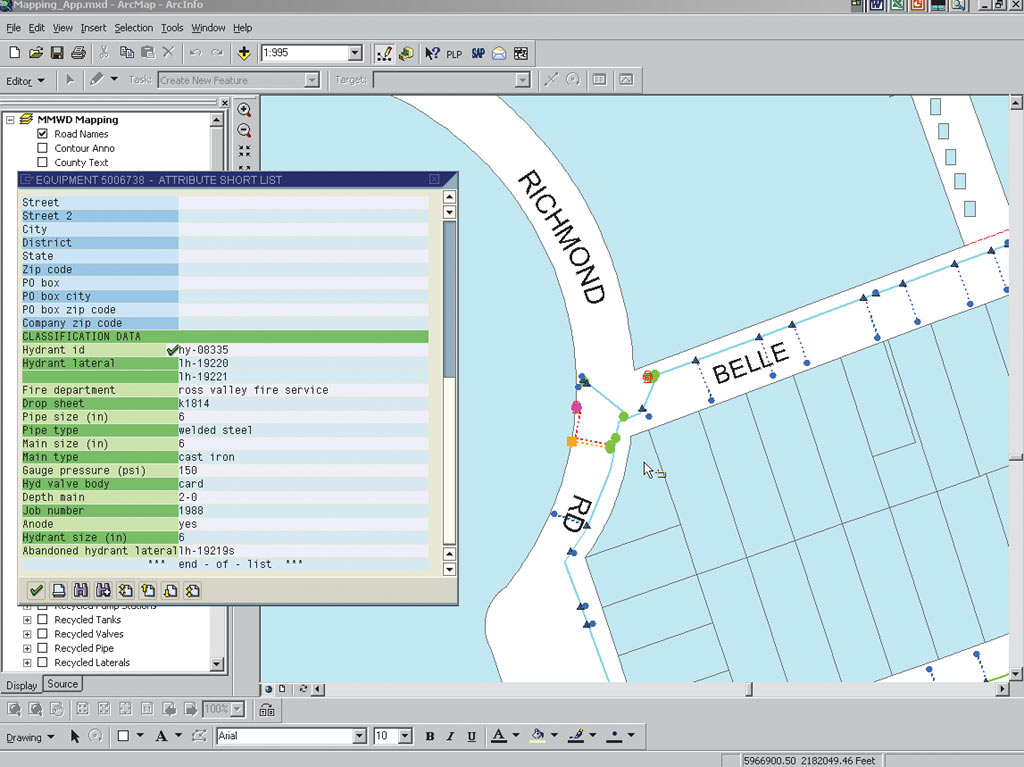
Marin Municipal Water District (MMWD) is the public agency that provides high-quality drinking water to approximately 185,000 people in a 147-square-mile area of Marin County. For the past 10 years, staff has been using GIS to update, inventory, and maintain water infrastructure data and to re-create paper maps used by MMWD personnel. In 2001, MMWD implemented SAP and replaced most of its legacy systems. (See also Aspects of Esri–SAP Integration at Marin Municipal Water District.) This included replacing its work order system that stored all water infrastructure attributes, such as pipe size and material type. MMWD, however, still needed to access its equipment attribute data, now located in its SAP database, using GIS. MMWD began integrating ArcInfo with SAP during the SAP implementation phase. Since early 2003, MMWD has been working with Esri Business Partner Cybertech Systems, Inc. (Naperville, Illinois, and Trevose, Pennsylvania), to tune, update, and improve its GIS–SAP interface. Cybertech was chosen for its proven track record in Esri–SAP integration and for high marks from clients. It brought an array of skill sets, as well as integration ideas, to the project.
Gavin McGhie, MMWD's GIS coordinator, says, "The combination of these two systems has created an extremely powerful tool that provides users access to SAP information via a user-friendly map-based interface. Strengths of SAP are that it controls business processes and rules and maintains data integrity and relationships. Thus, GIS efforts are focused on the spatial aspect of the data. GIS allows users to browse a familiar-looking map; point to a feature; and, with the click of a button, obtain information about that feature from SAP." McGhie explains, "Having ArcInfo integrated with SAP gives the staff access to a wide variety of information that previously required it to hunt and gather information from various locations within the MMWD offices. It is a definite time-saver." The GIS interface to SAP is especially useful to workers needing field information. Because the majority of the SAP work flow is related to location, workers can easily access SAP through intuitive GIS tools. Workers simply point to features on the map and GIS interfaces with SAP to quickly locate a diverse set of assets. With GIS, users can view relevant SAP asset data within a single window, thus making projects more manageable. Interface ApplicationsMMWD GIS personnel created several timesaving applications by using the interface between GIS and SAP. For example, the engineering department can use a UNIX workstation GIS function to add an existing pipe, valve, or meter and then access SAP to add attribute information. Through ArcGIS access, users have an inquiry option, which simplifies gathering information, such as a pipe's length and diameter or the types of material used for certain kinds of equipment. A Pipe Location Packet (PLP) application allows a user to select a set of service meters and/or fire lines in GIS and click a single button to prepare a PLP file for SAP. The user is then directed to open SAP and run a custom transaction that retrieves the file and creates a PLP based on the selected file's contents. This process previously took several hours or more, depending on the number of affected services. The application reduces the process to minutes.
A similar mailing label application helps users select a set of customers (by their service meter) and create a mailing label notification list. This is useful for notifying water customers about work being done in their area or possible water outages. Again, the process is reduced from hours to minutes. Currently, field crews are equipped with laptops loaded with ArcReader and GIS data sets required for their work. This gives crews a dynamic map so they can zoom into a high level of detail. Field GIS applications are continually being designed to meet workers' needs. For example, field crews need access to data found in the SAP system, but it is unrealistic to carry the SAP database into the field. An option being considered to make this data available involves extracting data from SAP and linking it to GIS data manually on a scheduled basis. Another option is to offer remote access via a wireless connection to both GIS and SAP. The GIS–SAP interface gives users fast access to asset location data. Users search for locations by information, such as known equipment numbers, addresses, cross streets, parcel numbers, and GPS coordinates. Once they locate their area of interest, they easily access a site's asset information both graphically on the map and by means of SAP attributes. MMWD's current interface allows editing by using its legacy ArcInfo and new SAP systems. Continuing EffortsMMWD is in the process of migrating to ArcGIS software. After the data has been migrated and the new environment is stable, MMWD will move its mature editing environment to ArcGIS and take advantage of all the new functionality. The PLP and Mailing Label applications are already available in ArcGIS. In the near future, MMWD plans to provide access to SAP work orders and notifications. Ideally, this will give field-workers the ability to remotely retrieve, create, modify, and close work orders from a map-based environment. This will require either wireless access or the ability to synchronize users' laptops when they return from the field. Additionally, MMWD plans to allow workers to select an area of interest and request a list of all work orders in that area for a given time period. MMWD intends to begin developing ArcIMS Web applications initially for internal use and eventually to provide information to its customers. These applications will most likely require an interface with SAP. The Web application will enable customers to locate their residences by address or other search criteria, such as their customer number. Upon locating an area of interest, Web site visitors could see where their service meters are located and request information, such as consumption information. They would also be able to determine in which Board Division they are located, their billing area, and so forth. Currently, the interface is one way, from GIS to SAP. Eventually GIS maps will be accessible from within the SAP side of the interface. This means users will be able to view a piece of equipment in SAP and have the option to view a comprehensive map of the area around that equipment. The result of integrating these two top-tier systems is an extremely powerful tool. Information will be easily shared among the various departments and will be distributed in a timelier manner, if not real time. SAP provides the backbone for running the business while GIS provides the spatial aspects needed to see the whole picture. For more information, contact Gavin McGhie, MMWD GIS coordinator (e-mail: gmcghie@marinwater.org). |
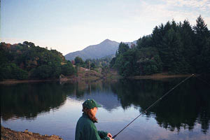
 Gentle streams flow through the rolling hills of Marin County, California, where children dive from shady banks into the cool waters. At its southern tip, the graceful cables of the Golden Gate Bridge span the Pacific entrance to San Francisco Bay. The wealth of Marin has always been its water. In the 1800s, waterways were harnessed to move logs for a booming lumber company and to turn the waterwheel at a large paper mill. Not long after, the shipping industry served to economically enrich the county. Today, little towns with scenic coastal vistas offer outdoor cafes and hilly residential areas with Mediterranean appeal. Residents of Marin County value the region's water resources and use the latest technology to efficiently manage it.