Fall 2004
Fall 2004 |
|||||||
|
|
|||||||
Gulf of Maine Research Institute Uses Internet Technology
Monitoring Cod in the Gulf of Maine |
|||||
|
The concept is simple: Capture 100,000 Atlantic cod, tag them, turn them loose, and wait for fishermen to catch them. After fishermen report the catch locations, scientists can analyze the results to determine cod movements, migration patterns, and growth information.
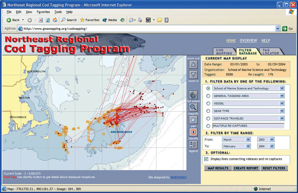
However, the execution is a bit more difficult. How do you coordinate the tagging efforts of six participating marine research organizations spanning Maritime Canada to Cape Cod, Massachusetts? How do you entice the people who find tagged cod to report them? And how do you help scientists keep track of individual fish when they're dealing with 100,000 of them? Evolution of the Cod Tagging ProgramResearchers at the Gulf of Maine Research Institute (GMRI) in Portland, Maine, asked themselves these questions and more. GMRI is the coordinating organization for the Northeast Regional Cod Tagging Program. The program, funded by the National Oceanic and Atmospheric Administration Fisheries, Northeast Regional Office, was developed because, despite many theories on how Atlantic cod move in the Gulf of Maine, neighboring Canadian waters, and southern New England waters, there is little consensus in the research literature to date. Dr. Shelly Tallack, program manager at GMRI, says, "Researchers need in-depth, accurate information throughout the Gulf of Maine to assist in monitoring and improving this important fishing resource." Scientists hope to answer many questions about Atlantic cod with the resulting data. Has the distribution and migration changed over the years? Are there separate inshore and offshore cod populations? How fast do cod grow in the Gulf of Maine? Where and when do spawning cod appear? Do movements change according to depth and water temperature? Early on, program managers realized that this project's strong geographic component leant itself to a mapping solution for tracking the tagging efforts and the locations of recaptured fish. If the spatial data could be made available over the Internet in near real time, participating scientists and managers could use the maps to optimize tagging efforts on upcoming trips. As an added benefit, a mapping site would pique interest in the program and serve to encourage individuals to report tagged cod. Tallack says, "The success of the project largely depends on fishermen reporting any tagged cod they catch. We felt a mapping site that allowed fishermen to see where their cod came from would help persuade them to report their tags." Collecting the DataBased on their experience developing ArcIMS applications and on several successful collaborations over the last few years, GMRI selected Esri Business Partner Northern Geomantics Inc. (NGI) of Hallowell, Maine, to develop the mapping site it desired. Initially, GMRI leaned toward each organization maintaining its own database and merging it regularly into a master database on the ArcIMS server. However, NGI realized that this type of data coordination would encounter two major stumbling blocks: (1) the lack of a single database standard among the organizations and (2) the potentially inconsistent methods of data entry and error checking. As a solution, NGI proposed to develop a Web-based data entry application in addition to the mapping Web site. The application allows users with varying levels of access to remotely populate a central SQL Server and ArcSDE database using a consistent interface.
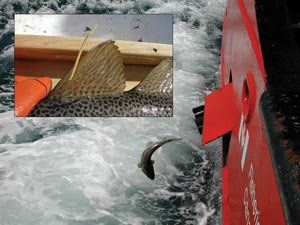
During a tagging cruise, researchers record tag numbers, fish length, and location as the cod are tagged and returned to the water. The uniquely numbered tags are three inches long and are attached to a dorsal fin with the same plastic tag holders used in department stores. Once back in port, the researchers can use any Internet connection to transfer a trip's tag and fish information to the master database through the data entry application. After the initial tagging data is entered, project staff at GMRI's Portland, Maine, office uses additional administrative functionality to review the data and check for errors. When an administrator approves the data, a series of spatial data functions are executed that populate the ArcSDE layers with release locations and fish movement paths. The data is then accessible using the ArcIMS mapping Web site. The spatial functions were developed using NGI's Java classes and Esri's ArcSDE application program interface to allow multiple users to build spatial data using a Web interface. The Web SiteThe Web site (www.gmamapping.org/codmapping) allows visitors to see the release and recapture locations of all fish tagged to date. Researchers using the site can query the cod database to display only fish that meet certain criteria such as those tagged by a specific organization or during a particular time frame. Using these tools, researchers can look for seasonal patterns of movement and other trends. Fish that have been recaptured can be linked back to their release location and queried to display their release date, percent growth since release, and distance traveled. Users can also create a printable map with this information. Equally as important as the mapping capabilities are the site's recapture reporting tools for those who find a tagged cod. Each tag includes the Web site address and a phone number. Fish finders can use the Web site to input the tag number and coordinates of the capture location. The initial tagging location of "their" cod is then displayed on the map, and information is given on how to claim a reward of a cap, mug, or T-shirt. Finders can also create a printable map that includes other information about their cod such as what organization tagged it and when it was released. ConclusionAlthough tagging only started in late March 2003, nearly 50,000 fish have been tagged and more than 900 recaptures have been reported. Already, specific patterns of movement are apparent in fish released in certain areas. Some tags have also popped up in unexpected locations, including the Fulton Fish Market in New York City where a patron found one attached to a filet he had purchased for dinner. Over the course of two years the program plans to tag a total of 100,000 fish. Tallack is optimistic that the Northeast Regional Cod Tagging Program will attain a return rate of 5-10 percent: "We've been impressed with the interest shown in the site by fishermen. The site allows them to more actively participate in the project and that should hopefully be reflected in more tag responses.." More tag returns mean more data, and more data will help scientists, fishermen, and managers develop policies that help ensure a healthy supply of Atlantic cod to support the important fishing industry along the Gulf of Maine coast for years to come. For more information, contact Dr. Shelly Tallack, manager, Northeast Regional Cod Tagging Program, Gulf of Maine Research Institute (tel.: 207-772-2321, ext. 1001; e-mail: stallack@gmri.org; Web: www.gma.org), or Bill Duffy, president, Northern Geomantics (tel.: 207-623-9226, e-mail: bduffy@northgeo.com, Web: www.northgeo.com). |